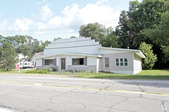
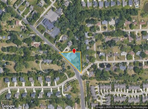
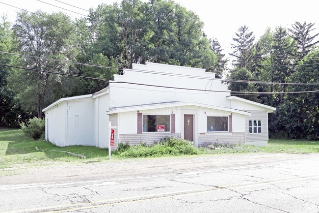
Property Record
1285 Union Lake Rd, White Lake, MI 48386
NEARBY LISTINGS FOR SALE OR LEASE
Property Detail
1285 Union Lake Rd
12-36-402-011
T3N, R8E, SEC 36 PART OF W 1/2 OF SE 1/4 BEG ON N & S 1/8 LINE DIST S 898.37 FT FROM NE COR OF SD W 1/2, TH S 254.48 FT, TH N 45-14-00 W ALG CEN OF ROAD 361.36 FT, TH E 256.56 FT TO BEG 0.75 A Y554
Auditorium
Oakland
X
Michigan
26125C0477F
0.75 AC
2024
St Clair & Lapeer Counties
2024
Detroit
130700
Detroit-Warren-Dearborn, MI
4,585 SF
DEMOGRAPHICS near 1285 Union Lake Rd
1 Mile
3 Mile
5 Mile
2024 Total Population
6,262
48,501
113,910
2029 Population
6,276
48,162
112,859
Pop Growth 2024-2029
+ 0.22%
(0.70%)
(0.92%)
Average Age
43
42
43
2024 Total Households
2,501
19,350
45,822
HH Growth 2024-2029
+ 0.24%
(0.69%)
(0.95%)
Median Household Inc
$82,516
$91,498
$90,399
Avg Household Size
2.50
2.50
2.40
2024 Avg HH Vehicles
2.00
2.00
2.00
Median Home Value
$278,043
$284,480
$292,542
Median Year Built
1985
1979
1978
Nearby Places
Map Layers
Map Styles
 Street
 Aerial
- Restaurants
- Banks
- Shops
- Fitness
- Groceries
PUBLIC TRANSPORTATION
COMMUTER RAIL
Pontiac Amtrak Station (Wolverine - Amtrak)
DRIVE
WALK
Distance
Pontiac Amtrak Station (Wolverine - Amtrak)
19 min
9.4 mi
AIRPORT
Detroit Metro Wayne County
DRIVE
WALK
Distance
Detroit Metro Wayne County
45 min
35.1 mi
Bishop International
DRIVE
WALK
Distance
Bishop International
55 min
35.4 mi
Freight Ports
Port of Toledo
DRIVE
WALK
Distance
Port of Toledo
95 min
76.7 mi
Nearby Properties
Address
Land Use
TOTAL SIZE
Lot Size
Zoning
Address
Land Use
TOTAL SIZE
Lot Size
Zoning
300,934 SF
25.30 AC
AI
Address
Land Use
TOTAL SIZE
Lot Size
Zoning
240,398 SF
23.50 AC
AI
Address
Land Use
TOTAL SIZE
Lot Size
Zoning
190,753 SF
16.54 AC
AI
Address
Land Use
TOTAL SIZE
Lot Size
Zoning
219,124 SF
18.63 AC
AI
Address
Land Use
TOTAL SIZE
Lot Size
Zoning
150,669 SF
16.57 AC
AI
Address
Land Use
TOTAL SIZE
Lot Size
Zoning
147,624 SF
6.59 AC
AI
Address
Land Use
TOTAL SIZE
Lot Size
Zoning
169,638 SF
16.39 AC
Address
Land Use
TOTAL SIZE
Lot Size
Zoning
151,611 SF
12.16 AC
AI
Address
Land Use
TOTAL SIZE
Lot Size
Zoning
3,908 SF
54.90 AC
MM
Address
Land Use
TOTAL SIZE
Lot Size
Zoning
93,541 SF
21.75 AC
SV
Address
Land Use
TOTAL SIZE
Lot Size
Zoning
119,755 SF
14.03 AC
Address
Land Use
TOTAL SIZE
Lot Size
Zoning
97,080 SF
12.53 AC
BI
Address
Land Use
TOTAL SIZE
Lot Size
Zoning
65,034 SF
10.28 AC
AI
Address
Land Use
TOTAL SIZE
Lot Size
Zoning
92,821 SF
12.19 AC
BI
Address
Land Use
TOTAL SIZE
Lot Size
Zoning
135,053 SF
15.10 AC
PB
Address
Land Use
TOTAL SIZE
Lot Size
Zoning
91,376 SF
11.06 AC
BI
Address
Land Use
TOTAL SIZE
Lot Size
Zoning
70,716 SF
8.93 AC
BI
Address
Land Use
TOTAL SIZE
Lot Size
Zoning
25,155 SF
11.71 AC
BI
Address
Land Use
TOTAL SIZE
Lot Size
Zoning
66,154 SF
5.65 AC
BI
Address
Land Use
TOTAL SIZE
Lot Size
Zoning
49,726 SF
12.83 AC
BV
Address
Land Use
TOTAL SIZE
Lot Size
Zoning
67,656 SF
9.10 AC
AI
Address
Land Use
TOTAL SIZE
Lot Size
Zoning
66,154 SF
5.65 AC
BI
Address
Land Use
TOTAL SIZE
Lot Size
Zoning
14,090 SF
2.11 AC
BI
Address
Land Use
TOTAL SIZE
Lot Size
Zoning
44,594 SF
BI
Address
Land Use
TOTAL SIZE
Lot Size
Zoning
37,333 SF
4.67 AC
Address
Land Use
TOTAL SIZE
Lot Size
Zoning
18,416 SF
1.44 AC
Address
Land Use
TOTAL SIZE
Lot Size
Zoning
55,639 SF
5.22 AC
BI
Address
Land Use
TOTAL SIZE
Lot Size
Zoning
22,448 SF
BI
Address
Land Use
TOTAL SIZE
Lot Size
Zoning
14,667 SF
1.64 AC
BI
Address
Land Use
TOTAL SIZE
Lot Size
Zoning
28,404 SF
10.58 AC
BI
The World's #1 Commercial Real Estate Marketplace
Connect with us
© 2025 CoStar Group
The information above has been obtained from sources believed reliable. While we do not doubt its accuracy we have not verified it and make no guarantee, warranty or representation about it. It is your responsibility to independently confirm its accuracy and completeness. Any projections, opinions, assumptions, or estimates used are for example only and do not represent the current or future performance of the property. The value of this transaction to you depends on tax and other factors which should be evaluated by your tax, financial, and legal advisors. You and your advisors should conduct a careful, independent investigation of the property to determine to your satisfaction the suitability of the property for your needs.