Property Record
1285 Wallis St, Eugene, OR 97402
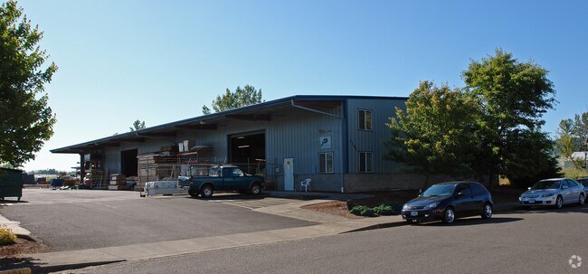

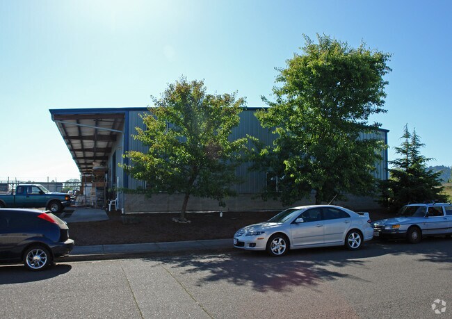
Property Detail
1285 Wallis St
Eugene-Springfield, OR
TL 03100
0465243
Lane
Industrialgeneral
Oregon
C-2
3100
AE The base floodplain where base flood elevations are provided. AE Zones are now used on new format FIRMs instead of A1-A30 Zones.
3.23 AC
2025
Lane County
2025
Portland
004406
NEARBY LISTINGS FOR SALE OR LEASE
DEMOGRAPHICS near 1285 Wallis St
1 mile
3 mile
5 mile
2024 Total Population
7,553
71,764
170,854
2029 Population
7,533
70,991
169,456
Pop Growth 2024-2029
(0.26%)
(1.08%)
(0.82%)
Average Age
39
41
40
2024 Total Households
3,118
29,394
70,356
HH Growth 2024-2029
(0.19%)
(1.23%)
(0.93%)
Median Household Inc
$71,114
$61,316
$64,283
Avg Household Size
2.30
2.20
2.20
2024 Avg HH Vehicles
2.00
2.00
2.00
Median Home Value
$384,684
$409,907
$450,400
Median Year Built
1980
1974
1976
Nearby Places
Map Layers
Map Styles
 Street
 Aerial
Transit
 Traffic
 Biking
Places
Listings with unknown addresses are not visible on the map
- Restaurants
- Banks
- Shops
- Fitness
- Groceries
PUBLIC TRANSPORTATION
COMMUTER RAIL
Eugene (Amtrak Cascades - Amtrak, Coast Starlight - Amtrak)
Drive
Walk
Distance
Eugene (Amtrak Cascades - Amtrak, Coast Starlight - Amtrak)
9 min
4.1 mi
AIRPORT
Mahlon Sweet Field
Drive
Walk
Distance
Mahlon Sweet Field
15 min
8.1 mi
Freight Ports
Port of Coos Bay, OR
Drive
Walk
Distance
Port of Coos Bay, OR
146 min
104.7 mi
SALE & LEASE HISTORY
LISTING DATE
SALE/LEASE

Mar 28, 2017
For Lease
Mar 06, 2017
For Lease
Nearby Properties
Address
Land Use
TOTAL SIZE
Lot Size
Zoning
Address
Land Use
TOTAL SIZE
Lot Size
Zoning
44.56 AC
PL
Address
Land Use
TOTAL SIZE
Lot Size
Zoning
Address
Land Use
TOTAL SIZE
Lot Size
Zoning
25.78 AC
C-2
Address
Land Use
TOTAL SIZE
Lot Size
Zoning
12.12 AC
C-2
Address
Land Use
TOTAL SIZE
Lot Size
Zoning
45.78 AC
I-3
Address
Land Use
TOTAL SIZE
Lot Size
Zoning
75.36 AC
PL
Address
Land Use
TOTAL SIZE
Lot Size
Zoning
14.14 AC
R-1
Address
Land Use
TOTAL SIZE
Lot Size
Zoning
19.65 AC
C-2
Address
Land Use
TOTAL SIZE
Lot Size
Zoning
3,324 SF
8.70 AC
NR
Address
Land Use
TOTAL SIZE
Lot Size
Zoning
12.07 AC
NR
Address
Land Use
TOTAL SIZE
Lot Size
Zoning
46.88 AC
PL
Address
Land Use
TOTAL SIZE
Lot Size
Zoning
29.96 AC
AG
Address
Land Use
TOTAL SIZE
Lot Size
Zoning
14.20 AC
R-1
Address
Land Use
TOTAL SIZE
Lot Size
Zoning
17.68 AC
PL
Address
Land Use
TOTAL SIZE
Lot Size
Zoning
7.38 AC
C-2
Address
Land Use
TOTAL SIZE
Lot Size
Zoning
Address
Land Use
TOTAL SIZE
Lot Size
Zoning
6.67 AC
PL
Address
Land Use
TOTAL SIZE
Lot Size
Zoning
0.62 AC
C-3
Address
Land Use
TOTAL SIZE
Lot Size
Zoning
Address
Land Use
TOTAL SIZE
Lot Size
Zoning
37.58 AC
PL
Address
Land Use
TOTAL SIZE
Lot Size
Zoning
13.14 AC
I-2
Address
Land Use
TOTAL SIZE
Lot Size
Zoning
4.97 AC
I-3
Address
Land Use
TOTAL SIZE
Lot Size
Zoning
23.08 AC
PL
Address
Land Use
TOTAL SIZE
Lot Size
Zoning
10.50 AC
C-2
Address
Land Use
TOTAL SIZE
Lot Size
Zoning
Address
Land Use
TOTAL SIZE
Lot Size
Zoning
5.13 AC
I-3
Address
Land Use
TOTAL SIZE
Lot Size
Zoning
3.12 AC
I-2
Address
Land Use
TOTAL SIZE
Lot Size
Zoning
7.68 AC
PL
Address
Land Use
TOTAL SIZE
Lot Size
Zoning
12.30 AC
C-2
Address
Land Use
TOTAL SIZE
Lot Size
Zoning
The World's #1 Commercial Real Estate Marketplace
Connect with us
© 2026 CoStar Group
The information above has been obtained from sources believed reliable. While we do not doubt its accuracy we have not verified it and make no guarantee, warranty or representation about it. It is your responsibility to independently confirm its accuracy and completeness. Any projections, opinions, assumptions, or estimates used are for example only and do not represent the current or future performance of the property. The value of this transaction to you depends on tax and other factors which should be evaluated by your tax, financial, and legal advisors. You and your advisors should conduct a careful, independent investigation of the property to determine to your satisfaction the suitability of the property for your needs.