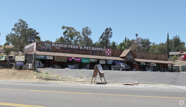
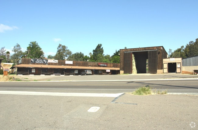
Property Record
12868 Campo Rd, Spring Valley, CA 91978


Property Detail
12868 Campo Rd
596-040-02
SEC 5-17-1E LOT 4 1.98 AC M/L IN W 10 AC OF
Servicestationmarket
SAN DIEGO
C36
California
B and X Area of moderate flood hazard, usually the area between the limits of the 100-year and 500-year floods.
4
2024
1.98 AC
2025
Lemon Grv/Spring Vly
021305
San Diego
5,987 SF
San Diego-Chula Vista-Carlsbad, CA
NEARBY LISTINGS FOR SALE OR LEASE
DEMOGRAPHICS near 12868 Campo Rd
1 mile
3 mile
5 mile
2025 Total Population
1,694
24,080
105,403
2030 Population
1,681
23,862
105,243
Pop Growth 2025-2030
(0.77%)
(0.91%)
(0.15%)
Average Age
44
42
41
2025 Total Households
522
8,303
34,974
HH Growth 2025-2030
(0.96%)
(1.26%)
(0.38%)
Median Household Inc
$139,329
$112,617
$106,180
Avg Household Size
3.00
2.80
2.90
2025 Avg HH Vehicles
3.00
2.00
2.00
Median Home Value
$1,059,170
$832,499
$804,966
Median Year Built
1981
1985
1978
Nearby Places
Map Layers
Map Styles
 Street
 Aerial
Layers
 Traffic
 Biking
Places
Listings with unknown addresses are not visible on the map
- Restaurants
- Banks
- Shops
- Fitness
- Groceries
PUBLIC TRANSPORTATION
AIRPORT
San Diego International
Drive
Walk
Distance
San Diego International
25 min
19.7 mi
Freight Ports
Port of San Diego
Drive
Walk
Distance
Port of San Diego
24 min
17.2 mi
Nearby Properties
Address
Land Use
TOTAL SIZE
Lot Size
Zoning
Address
Land Use
TOTAL SIZE
Lot Size
Zoning
15.64 AC
RU
Address
Land Use
TOTAL SIZE
Lot Size
Zoning
13.49 AC
RU
Address
Land Use
TOTAL SIZE
Lot Size
Zoning
10.98 AC
RV
Address
Land Use
TOTAL SIZE
Lot Size
Zoning
96,140 SF
3.65 AC
RU
Address
Land Use
TOTAL SIZE
Lot Size
Zoning
92,295 SF
6.50 AC
M52
Address
Land Use
TOTAL SIZE
Lot Size
Zoning
5.62 AC
C31
Address
Land Use
TOTAL SIZE
Lot Size
Zoning
15.71 AC
RV
Address
Land Use
TOTAL SIZE
Lot Size
Zoning
10.14 AC
C36
Address
Land Use
TOTAL SIZE
Lot Size
Zoning
10 AC
S88
Address
Land Use
TOTAL SIZE
Lot Size
Zoning
68,990 SF
7.58 AC
S88
Address
Land Use
TOTAL SIZE
Lot Size
Zoning
71.84 AC
S80
Address
Land Use
TOTAL SIZE
Lot Size
Zoning
65,784 SF
6.67 AC
S88
Address
Land Use
TOTAL SIZE
Lot Size
Zoning
62,676 SF
9.40 AC
C36
Address
Land Use
TOTAL SIZE
Lot Size
Zoning
69,629 SF
8.91 AC
A70
Address
Land Use
TOTAL SIZE
Lot Size
Zoning
141.70 AC
A70
Address
Land Use
TOTAL SIZE
Lot Size
Zoning
5,796 SF
10.39 AC
A72
Address
Land Use
TOTAL SIZE
Lot Size
Zoning
42,148 SF
3.36 AC
S88
Address
Land Use
TOTAL SIZE
Lot Size
Zoning
63,990 SF
10.98 AC
C36
Address
Land Use
TOTAL SIZE
Lot Size
Zoning
45,651 SF
4.19 AC
C36
Address
Land Use
TOTAL SIZE
Lot Size
Zoning
40,223 SF
2.80 AC
C36
Address
Land Use
TOTAL SIZE
Lot Size
Zoning
2.68 AC
M52
Address
Land Use
TOTAL SIZE
Lot Size
Zoning
73,720 SF
3.15 AC
C36
Address
Land Use
TOTAL SIZE
Lot Size
Zoning
18,800 SF
7.59 AC
R1
Address
Land Use
TOTAL SIZE
Lot Size
Zoning
44,485 SF
3.42 AC
C36
Address
Land Use
TOTAL SIZE
Lot Size
Zoning
29,487 SF
4.89 AC
C36
Address
Land Use
TOTAL SIZE
Lot Size
Zoning
2,330 SF
10.56 AC
RR
Address
Land Use
TOTAL SIZE
Lot Size
Zoning
32.71 AC
RMH8
Address
Land Use
TOTAL SIZE
Lot Size
Zoning
29,110 SF
3.09 AC
C36
Address
Land Use
TOTAL SIZE
Lot Size
Zoning
2.89 AC
S88
Address
Land Use
TOTAL SIZE
Lot Size
Zoning
1,152 SF
36.11 AC
A70
The World's #1 Commercial Real Estate Marketplace
Connect with us
© 2026 CoStar Group
The information above has been obtained from sources believed reliable. While we do not doubt its accuracy we have not verified it and make no guarantee, warranty or representation about it. It is your responsibility to independently confirm its accuracy and completeness. Any projections, opinions, assumptions, or estimates used are for example only and do not represent the current or future performance of the property. The value of this transaction to you depends on tax and other factors which should be evaluated by your tax, financial, and legal advisors. You and your advisors should conduct a careful, independent investigation of the property to determine to your satisfaction the suitability of the property for your needs.