Property Record
12875 Bryan Rd, Loxahatchee, FL 33470

NEARBY LISTINGS FOR SALE OR LEASE
Property Detail
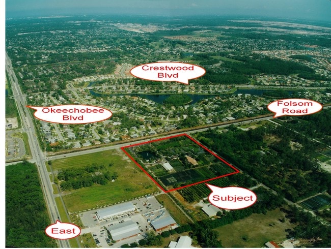
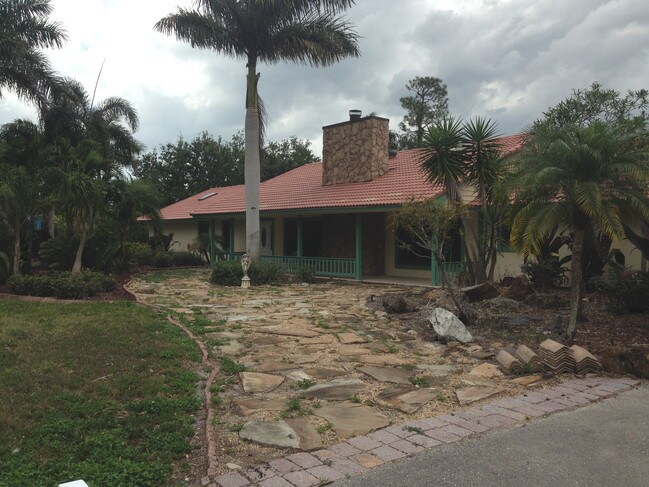
12875 Bryan Rd
41-41-43-17-01-634-0010
Loxahatchee Groves
Agriculturalland
LOXAHATCHEE GROVES E 769.72 FT OF TR 34 (LESS E 50.02 FT FOLSOM RD R/W) BLK F
AE
Palm Beach
12099C0553F
Florida
2024
9.39 AC
2025
Palm Bch Cty Outlying
007844
South Florida
3,230 SF
West Palm Beach-Boca Raton-Delray Beach, FL
DEMOGRAPHICS near 12875 Bryan Rd
1 Mile
3 Mile
5 Mile
2024 Total Population
4,962
50,359
113,519
2029 Population
5,001
51,131
115,957
Pop Growth 2024-2029
+ 0.79%
+ 1.53%
+ 2.15%
Average Age
42
40
40
2024 Total Households
1,731
17,019
39,305
HH Growth 2024-2029
+ 0.17%
+ 0.83%
+ 1.52%
Median Household Inc
$89,710
$91,882
$91,286
Avg Household Size
2.70
2.80
2.80
2024 Avg HH Vehicles
2.00
2.00
2.00
Median Home Value
$333,781
$365,949
$388,824
Median Year Built
1992
1987
1991
Nearby Places
Map Layers
Map Styles
 Street
 Aerial
- Restaurants
- Banks
- Shops
- Fitness
- Groceries
PUBLIC TRANSPORTATION
AIRPORT
Palm Beach International
DRIVE
WALK
Distance
Palm Beach International
20 min
11.2 mi
Freight Ports
Port of Palm Beach
DRIVE
WALK
Distance
Port of Palm Beach
31 min
16.2 mi
SALE & LEASE HISTORY
LISTING DATE
SALE/LEASE

Sep 24, 2016
For Sale
Nov 07, 2018
For Sale
Apr 13, 2017
For Lease
Nearby Properties
Address
Land Use
TOTAL SIZE
Lot Size
Zoning
Address
Land Use
TOTAL SIZE
Lot Size
Zoning
398,622 SF
21.62 AC
RM-18
Address
Land Use
TOTAL SIZE
Lot Size
Zoning
669,818 SF
42.79 AC
IL
Address
Land Use
TOTAL SIZE
Lot Size
Zoning
349,316 SF
49.95 AC
CG
Address
Land Use
TOTAL SIZE
Lot Size
Zoning
159,302 SF
29.36 AC
Address
Land Use
TOTAL SIZE
Lot Size
Zoning
302,692 SF
55 AC
PO
Address
Land Use
TOTAL SIZE
Lot Size
Zoning
243,076 SF
15.47 AC
RM-18
Address
Land Use
TOTAL SIZE
Lot Size
Zoning
255,345 SF
15.34 AC
IPF
Address
Land Use
TOTAL SIZE
Lot Size
Zoning
190,294 SF
18.71 AC
PUD
Address
Land Use
TOTAL SIZE
Lot Size
Zoning
149,934 SF
3.47 AC
CG
Address
Land Use
TOTAL SIZE
Lot Size
Zoning
114,658 SF
14.99 AC
CG
Address
Land Use
TOTAL SIZE
Lot Size
Zoning
156,427 SF
13.79 AC
PUD
Address
Land Use
TOTAL SIZE
Lot Size
Zoning
81,309 SF
22.90 AC
CO
Address
Land Use
TOTAL SIZE
Lot Size
Zoning
127,074 SF
7.90 AC
IL
Address
Land Use
TOTAL SIZE
Lot Size
Zoning
152,387 SF
8.46 AC
IL
Address
Land Use
TOTAL SIZE
Lot Size
Zoning
85,077 SF
4.10 AC
MXD
Address
Land Use
TOTAL SIZE
Lot Size
Zoning
180,760 SF
30 AC
PO
Address
Land Use
TOTAL SIZE
Lot Size
Zoning
124,420 SF
6.47 AC
IL
Address
Land Use
TOTAL SIZE
Lot Size
Zoning
180,200 SF
18.21 AC
CG
Address
Land Use
TOTAL SIZE
Lot Size
Zoning
75,077 SF
6.40 AC
RMU
Address
Land Use
TOTAL SIZE
Lot Size
Zoning
203,668 SF
19.18 AC
CG
Address
Land Use
TOTAL SIZE
Lot Size
Zoning
79,746 SF
10.99 AC
CG
Address
Land Use
TOTAL SIZE
Lot Size
Zoning
123,753 SF
19.98 AC
PUD
Address
Land Use
TOTAL SIZE
Lot Size
Zoning
123,529 SF
20 AC
PO
Address
Land Use
TOTAL SIZE
Lot Size
Zoning
72,781 SF
23.65 AC
PUD
Address
Land Use
TOTAL SIZE
Lot Size
Zoning
122,559 SF
15 AC
PUD
Address
Land Use
TOTAL SIZE
Lot Size
Zoning
122,338 SF
14.24 AC
CG
Address
Land Use
TOTAL SIZE
Lot Size
Zoning
98,538 SF
2.45 AC
CL
Address
Land Use
TOTAL SIZE
Lot Size
Zoning
77,863 SF
6.19 AC
CG
Address
Land Use
TOTAL SIZE
Lot Size
Zoning
103,509 SF
7.32 AC
PO
Address
Land Use
TOTAL SIZE
Lot Size
Zoning
107,177 SF
3.39 AC
IL
The World's #1 Commercial Real Estate Marketplace
Connect with us
© 2026 CoStar Group
The information above has been obtained from sources believed reliable. While we do not doubt its accuracy we have not verified it and make no guarantee, warranty or representation about it. It is your responsibility to independently confirm its accuracy and completeness. Any projections, opinions, assumptions, or estimates used are for example only and do not represent the current or future performance of the property. The value of this transaction to you depends on tax and other factors which should be evaluated by your tax, financial, and legal advisors. You and your advisors should conduct a careful, independent investigation of the property to determine to your satisfaction the suitability of the property for your needs.