Property Record
12888 E Nc Highway 97, Rocky Mount, NC 27803
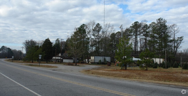
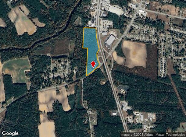
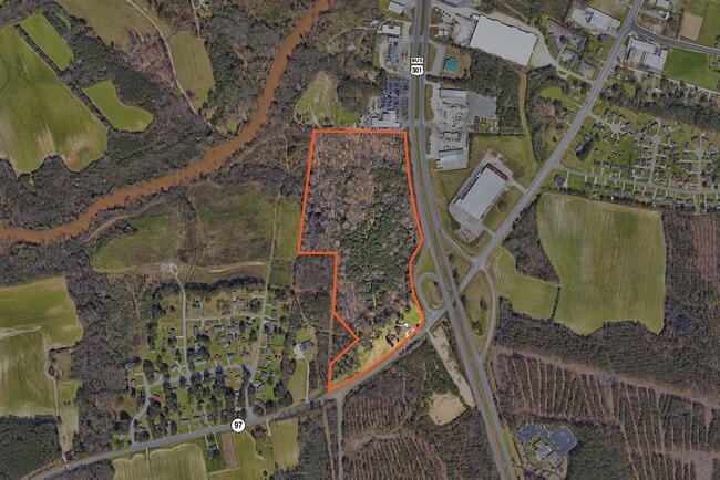
This Property Is For Sale
NEARBY LISTINGS FOR SALE OR LEASE
Property Detail
12888 E Nc Highway 97
Rocky Mount, NC
Nash
3748-07-59-5493
North Carolina
Sfr
20.92 AC
AE
Rocky Mount/Wilson
3720374800J
Other Market Areas
1,336 SF
DEMOGRAPHICS near 12888 E Nc Highway 97
1 Mile
3 Mile
5 Mile
2024 Total Population
2,106
24,771
51,219
2029 Population
2,181
25,445
52,344
Pop Growth 2024-2029
+ 3.56%
+ 2.72%
+ 2.20%
Average Age
40
41
41
2024 Total Households
882
10,418
21,757
HH Growth 2024-2029
+ 3.40%
+ 2.68%
+ 2.21%
Median Household Inc
$50,212
$40,455
$43,896
Avg Household Size
2.30
2.30
2.30
2024 Avg HH Vehicles
2.00
2.00
2.00
Median Home Value
$116,393
$122,703
$136,686
Median Year Built
1972
1973
1977
Nearby Places
- Restaurants
- Banks
- Shops
- Fitness
- Groceries
PUBLIC TRANSPORTATION
COMMUTER RAIL
Rocky Mount (Carolinian - Amtrak, Palmetto - Amtrak, Silver Meteor - Amtrak, Silver Star - Amtrak)
DRIVE
WALK
Distance
Rocky Mount (Carolinian - Amtrak, Palmetto - Amtrak, Silver Meteor - Amtrak, Silver Star - Amtrak)
6 min
3.0 mi
Freight Ports
Port of Morehead City
DRIVE
WALK
Distance
Port of Morehead City
185 min
134.1 mi
Nearby Properties
Address
Land Use
TOTAL SIZE
Lot Size
Zoning
Address
Land Use
TOTAL SIZE
Lot Size
Zoning
130,639 SF
60.52 AC
A1M
Address
Land Use
TOTAL SIZE
Lot Size
Zoning
10,632 SF
16.61 AC
R6
Address
Land Use
TOTAL SIZE
Lot Size
Zoning
79,027 SF
33.37 AC
R10
Address
Land Use
TOTAL SIZE
Lot Size
Zoning
29,504 SF
18.61 AC
Address
Land Use
TOTAL SIZE
Lot Size
Zoning
8,216 SF
4.21 AC
B4
Address
Land Use
TOTAL SIZE
Lot Size
Zoning
32,051 SF
18.50 AC
R6
Address
Land Use
TOTAL SIZE
Lot Size
Zoning
15,650 SF
32.25 AC
R10
Address
Land Use
TOTAL SIZE
Lot Size
Zoning
118,800 SF
5.51 AC
I
Address
Land Use
TOTAL SIZE
Lot Size
Zoning
6,253 SF
16.22 AC
A1
Address
Land Use
TOTAL SIZE
Lot Size
Zoning
26,401 SF
7.50 AC
R10
Address
Land Use
TOTAL SIZE
Lot Size
Zoning
3,360 SF
6.27 AC
R10
Address
Land Use
TOTAL SIZE
Lot Size
Zoning
29,187 SF
29.05 AC
R10
Address
Land Use
TOTAL SIZE
Lot Size
Zoning
2,888 SF
3.35 AC
Address
Land Use
TOTAL SIZE
Lot Size
Zoning
52,789 SF
21.90 AC
I2
Address
Land Use
TOTAL SIZE
Lot Size
Zoning
42,113 SF
1.13 AC
B4
Address
Land Use
TOTAL SIZE
Lot Size
Zoning
Address
Land Use
TOTAL SIZE
Lot Size
Zoning
50,384 SF
1.92 AC
B4
Address
Land Use
TOTAL SIZE
Lot Size
Zoning
1,298 SF
10.51 AC
R6
Address
Land Use
TOTAL SIZE
Lot Size
Zoning
55,934 SF
2 AC
B5
Address
Land Use
TOTAL SIZE
Lot Size
Zoning
41,452 SF
5.55 AC
RC
Address
Land Use
TOTAL SIZE
Lot Size
Zoning
11,708 SF
6.10 AC
R10
Address
Land Use
TOTAL SIZE
Lot Size
Zoning
27,571 SF
6.98 AC
R6
Address
Land Use
TOTAL SIZE
Lot Size
Zoning
2,134 SF
9.10 AC
R6
Address
Land Use
TOTAL SIZE
Lot Size
Zoning
7,728 SF
0.68 AC
B4
Address
Land Use
TOTAL SIZE
Lot Size
Zoning
38,578 SF
1.90 AC
R10
Address
Land Use
TOTAL SIZE
Lot Size
Zoning
69,953 SF
1.49 AC
B4
Address
Land Use
TOTAL SIZE
Lot Size
Zoning
21,281 SF
4.13 AC
Address
Land Use
TOTAL SIZE
Lot Size
Zoning
20,056 SF
2.38 AC
R10
Address
Land Use
TOTAL SIZE
Lot Size
Zoning
9,000 SF
10.54 AC
R30
Address
Land Use
TOTAL SIZE
Lot Size
Zoning
50,744 SF
9.70 AC
The World's #1 Commercial Real Estate Marketplace
Connect with us
© 2025 CoStar Group
The information above has been obtained from sources believed reliable. While we do not doubt its accuracy we have not verified it and make no guarantee, warranty or representation about it. It is your responsibility to independently confirm its accuracy and completeness. Any projections, opinions, assumptions, or estimates used are for example only and do not represent the current or future performance of the property. The value of this transaction to you depends on tax and other factors which should be evaluated by your tax, financial, and legal advisors. You and your advisors should conduct a careful, independent investigation of the property to determine to your satisfaction the suitability of the property for your needs.