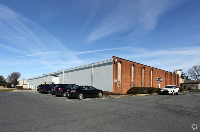
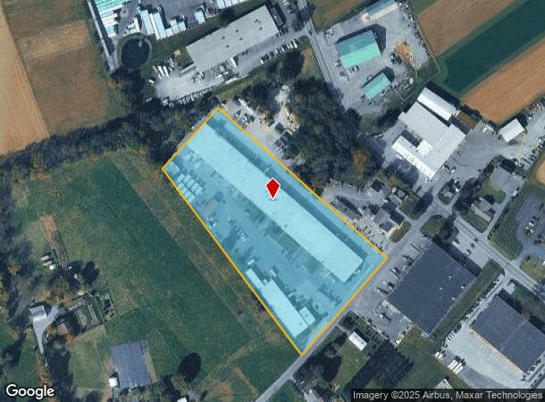
Property Record
97 Ashmore Dr, Leola, PA 17540


Current Lease Availabilities
NEARBY LISTINGS FOR SALE OR LEASE
Property Detail
97 Ashmore Dr
Lancaster, PA
Melvin S Huyard
360-93201-0-0000
97 ASHMORE DR
Lightindustrial
Lancaster
X
Pennsylvania
42071C0385F
4b
2024
6.30 AC
2025
Lancaster County
013102
Philadelphia
86,974 SF
DEMOGRAPHICS near 97 Ashmore Dr
1 Mile
3 Mile
5 Mile
2024 Total Population
2,334
13,093
47,088
2029 Population
2,346
13,083
47,153
Pop Growth 2024-2029
+ 0.51%
(0.08%)
+ 0.14%
Average Age
37
37
40
2024 Total Households
806
4,383
17,215
HH Growth 2024-2029
+ 0.62%
(0.02%)
+ 0.20%
Median Household Inc
$69,565
$80,004
$83,581
Avg Household Size
2.80
2.90
2.70
2024 Avg HH Vehicles
2.00
2.00
2.00
Median Home Value
$276,723
$296,203
$286,334
Median Year Built
1978
1975
1978
Nearby Places
- Restaurants
- Banks
- Shops
- Fitness
- Groceries
PUBLIC TRANSPORTATION
COMMUTER RAIL
DRIVE
WALK
Distance
18 min
9.1 mi
AIRPORT
Harrisburg International
DRIVE
WALK
Distance
Harrisburg International
52 min
39.3 mi
Freight Ports
Port Newark Container Terminal
DRIVE
WALK
Distance
Port Newark Container Terminal
81 min
46.4 mi
Nearby Properties
Address
Land Use
TOTAL SIZE
Lot Size
Zoning
Address
Land Use
TOTAL SIZE
Lot Size
Zoning
403,771 SF
106.93 AC
Address
Land Use
TOTAL SIZE
Lot Size
Zoning
2,615,989 SF
147.50 AC
I
Address
Land Use
TOTAL SIZE
Lot Size
Zoning
419,136 SF
34.11 AC
Address
Land Use
TOTAL SIZE
Lot Size
Zoning
74,841 SF
16.20 AC
R-1
Address
Land Use
TOTAL SIZE
Lot Size
Zoning
111,896 SF
8.30 AC
Address
Land Use
TOTAL SIZE
Lot Size
Zoning
71,600 SF
15.20 AC
C-2
Address
Land Use
TOTAL SIZE
Lot Size
Zoning
246,116 SF
16.30 AC
R-2
Address
Land Use
TOTAL SIZE
Lot Size
Zoning
109,200 SF
12.97 AC
R-2
Address
Land Use
TOTAL SIZE
Lot Size
Zoning
122,854 SF
11.40 AC
R-2
Address
Land Use
TOTAL SIZE
Lot Size
Zoning
105,946 SF
30.23 AC
I
Address
Land Use
TOTAL SIZE
Lot Size
Zoning
155,342 SF
7.38 AC
Address
Land Use
TOTAL SIZE
Lot Size
Zoning
48,827 SF
7.60 AC
GC
Address
Land Use
TOTAL SIZE
Lot Size
Zoning
133,788 SF
10.10 AC
I
Address
Land Use
TOTAL SIZE
Lot Size
Zoning
40,425 SF
6.22 AC
GC
Address
Land Use
TOTAL SIZE
Lot Size
Zoning
79,551 SF
8.70 AC
C-1
Address
Land Use
TOTAL SIZE
Lot Size
Zoning
109,396 SF
19.60 AC
I
Address
Land Use
TOTAL SIZE
Lot Size
Zoning
112,433 SF
14.60 AC
Address
Land Use
TOTAL SIZE
Lot Size
Zoning
86,050 SF
7.06 AC
I
Address
Land Use
TOTAL SIZE
Lot Size
Zoning
96,870 SF
10.98 AC
I
Address
Land Use
TOTAL SIZE
Lot Size
Zoning
106,542 SF
19.30 AC
I
Address
Land Use
TOTAL SIZE
Lot Size
Zoning
96,536 SF
15.10 AC
I
Address
Land Use
TOTAL SIZE
Lot Size
Zoning
70,190 SF
10.28 AC
I
Address
Land Use
TOTAL SIZE
Lot Size
Zoning
58,895 SF
4.70 AC
GC
Address
Land Use
TOTAL SIZE
Lot Size
Zoning
108,675 SF
30.53 AC
I
Address
Land Use
TOTAL SIZE
Lot Size
Zoning
47,041 SF
11.20 AC
R-2
Address
Land Use
TOTAL SIZE
Lot Size
Zoning
27,136 SF
3.40 AC
Address
Land Use
TOTAL SIZE
Lot Size
Zoning
27,818 SF
8 AC
R-1
Address
Land Use
TOTAL SIZE
Lot Size
Zoning
26,443 SF
84.60 AC
A
Address
Land Use
TOTAL SIZE
Lot Size
Zoning
80,389 SF
5.31 AC
I
The World's #1 Commercial Real Estate Marketplace
Connect with us
© 2025 CoStar Group
The information above has been obtained from sources believed reliable. While we do not doubt its accuracy we have not verified it and make no guarantee, warranty or representation about it. It is your responsibility to independently confirm its accuracy and completeness. Any projections, opinions, assumptions, or estimates used are for example only and do not represent the current or future performance of the property. The value of this transaction to you depends on tax and other factors which should be evaluated by your tax, financial, and legal advisors. You and your advisors should conduct a careful, independent investigation of the property to determine to your satisfaction the suitability of the property for your needs.