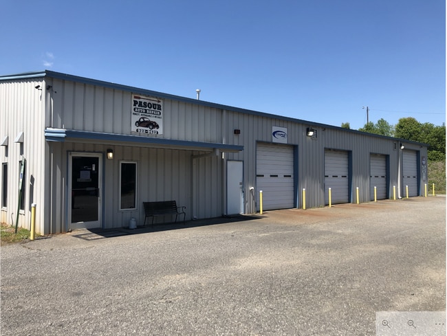
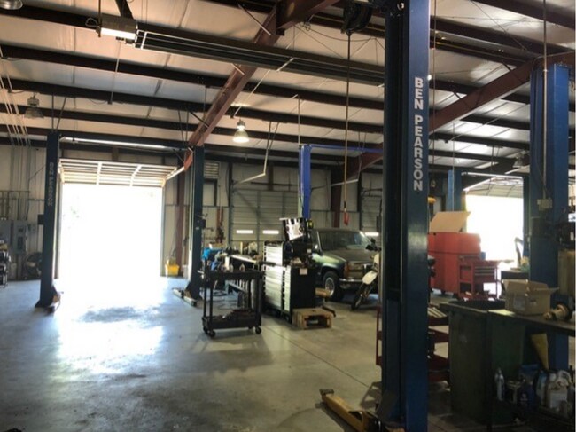
Property Record
129 Durkee Ln, Dallas, NC 28034

NEARBY LISTINGS FOR SALE OR LEASE
Property Detail
129 Durkee Ln
170805
13 088 003 07 000
Commercialofficeresidentialmixeduse
Gaston
X
North Carolina
3710353700J
3.03 AC
2025
Gaston County
2025
Charlotte
0304022001
Charlotte-Concord-Gastonia, NC-SC
6,000 SF
DEMOGRAPHICS near 129 Durkee Ln
1 Mile
3 Mile
5 Mile
2024 Total Population
2,227
14,927
56,718
2029 Population
2,423
15,988
60,657
Pop Growth 2024-2029
+ 8.80%
+ 7.11%
+ 6.94%
Average Age
41
39
39
2024 Total Households
784
5,867
22,291
HH Growth 2024-2029
+ 9.18%
+ 7.28%
+ 7.11%
Median Household Inc
$83,573
$49,193
$43,192
Avg Household Size
2.60
2.50
2.40
2024 Avg HH Vehicles
3.00
2.00
2.00
Median Home Value
$211,823
$200,975
$167,257
Median Year Built
1985
1980
1973
Nearby Places
Map Layers
Map Styles
 Street
 Aerial
- Restaurants
- Banks
- Shops
- Fitness
- Groceries
PUBLIC TRANSPORTATION
COMMUTER RAIL
DRIVE
WALK
Distance
12 min
6.7 mi
AIRPORT
Charlotte/Douglas International
DRIVE
WALK
Distance
Charlotte/Douglas International
37 min
21.5 mi
Concord-Padgett Regional
DRIVE
WALK
Distance
Concord-Padgett Regional
51 min
37.8 mi
SALE & LEASE HISTORY
LISTING DATE
SALE/LEASE

Apr 17, 2020
For Sale
Nearby Properties
Address
Land Use
TOTAL SIZE
Lot Size
Zoning
Address
Land Use
TOTAL SIZE
Lot Size
Zoning
11,696 SF
159.68 AC
Address
Land Use
TOTAL SIZE
Lot Size
Zoning
17.37 AC
Address
Land Use
TOTAL SIZE
Lot Size
Zoning
312,465 SF
35.23 AC
Address
Land Use
TOTAL SIZE
Lot Size
Zoning
192,315 SF
44.12 AC
INDS1
Address
Land Use
TOTAL SIZE
Lot Size
Zoning
2,250 SF
27.79 AC
OFF01
Address
Land Use
TOTAL SIZE
Lot Size
Zoning
539,988 SF
36.32 AC
STOR6
Address
Land Use
TOTAL SIZE
Lot Size
Zoning
Address
Land Use
TOTAL SIZE
Lot Size
Zoning
411,076 SF
67.01 AC
INDS2
Address
Land Use
TOTAL SIZE
Lot Size
Zoning
176,657 SF
16.19 AC
Address
Land Use
TOTAL SIZE
Lot Size
Zoning
154,681 SF
63.07 AC
INDS1
Address
Land Use
TOTAL SIZE
Lot Size
Zoning
163,100 SF
41.60 AC
INDS1
Address
Land Use
TOTAL SIZE
Lot Size
Zoning
16,776 SF
49.87 AC
PUB01
Address
Land Use
TOTAL SIZE
Lot Size
Zoning
148,300 SF
12.59 AC
INDS2
Address
Land Use
TOTAL SIZE
Lot Size
Zoning
1,914 SF
15.78 AC
MRKT1
Address
Land Use
TOTAL SIZE
Lot Size
Zoning
514,404 SF
27.84 AC
INDS2
Address
Land Use
TOTAL SIZE
Lot Size
Zoning
44,224 SF
3.32 AC
Address
Land Use
TOTAL SIZE
Lot Size
Zoning
4,228 SF
11.39 AC
APT02
Address
Land Use
TOTAL SIZE
Lot Size
Zoning
2,776 SF
57.41 AC
R1
Address
Land Use
TOTAL SIZE
Lot Size
Zoning
44,132 SF
1.90 AC
MOTL2
Address
Land Use
TOTAL SIZE
Lot Size
Zoning
2,053 SF
15.34 AC
OFF01
Address
Land Use
TOTAL SIZE
Lot Size
Zoning
64,342 SF
18.36 AC
Address
Land Use
TOTAL SIZE
Lot Size
Zoning
115,534 SF
50.10 AC
PUB01
Address
Land Use
TOTAL SIZE
Lot Size
Zoning
70,288 SF
13.42 AC
INDS1
Address
Land Use
TOTAL SIZE
Lot Size
Zoning
36,300 SF
15.83 AC
Address
Land Use
TOTAL SIZE
Lot Size
Zoning
163,106 SF
11.19 AC
STOR2
Address
Land Use
TOTAL SIZE
Lot Size
Zoning
84,111 SF
5.89 AC
Address
Land Use
TOTAL SIZE
Lot Size
Zoning
81,000 SF
10.31 AC
INDS2
Address
Land Use
TOTAL SIZE
Lot Size
Zoning
77,568 SF
1.65 AC
REST2
Address
Land Use
TOTAL SIZE
Lot Size
Zoning
43,164 SF
11.52 AC
SHOP1
Address
Land Use
TOTAL SIZE
Lot Size
Zoning
20,000 SF
23.07 AC
INDS1
The World's #1 Commercial Real Estate Marketplace
Connect with us
© 2026 CoStar Group
The information above has been obtained from sources believed reliable. While we do not doubt its accuracy we have not verified it and make no guarantee, warranty or representation about it. It is your responsibility to independently confirm its accuracy and completeness. Any projections, opinions, assumptions, or estimates used are for example only and do not represent the current or future performance of the property. The value of this transaction to you depends on tax and other factors which should be evaluated by your tax, financial, and legal advisors. You and your advisors should conduct a careful, independent investigation of the property to determine to your satisfaction the suitability of the property for your needs.