Property Record
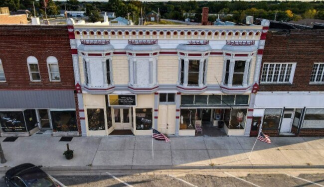
129 E 8Th St, Horton, KS 66439
Property Detail
129 E 8Th St
158-33-0-30-06-005.00-0
HORTON, BLOCK 025, LOT 6 & 7
Storebuilding
Brown
C2
Kansas
2024
6,7
2025
0.07 AC
480800
Kansas Area
2,050 SF
Other Market Areas
NEARBY LISTINGS FOR SALE OR LEASE
-
-
View all Horton listings for sale on LoopNet.com
DEMOGRAPHICS near 129 E 8Th St
1 mile
3 mile
5 mile
2025 Total Population
1,639
1,843
2,088
2030 Population
1,617
1,818
2,060
Pop Growth 2025-2030
(1.34%)
(1.36%)
(1.34%)
Average Age
43
43
43
2025 Total Households
683
767
863
HH Growth 2025-2030
(1.32%)
(1.43%)
(1.39%)
Median Household Inc
$43,804
$44,349
$46,282
Avg Household Size
2.30
2.30
2.30
2025 Avg HH Vehicles
2.00
2.00
2.00
Median Home Value
$79,999
$83,986
$89,221
Median Year Built
1954
1954
1954
Nearby Places
Map Layers
Map Styles
 Street
 Aerial
Layers
 Traffic
 Biking
Places
Listings with unknown addresses are not visible on the map
- Restaurants
- Banks
- Shops
- Fitness
- Groceries
SALE & LEASE HISTORY
LISTING DATE
SALE/LEASE

Feb 28, 2024
For Sale
Nearby Properties
Address
Land Use
TOTAL SIZE
Lot Size
Zoning
Address
Land Use
TOTAL SIZE
Lot Size
Zoning
36,120 SF
2.57 AC
R2
Address
Land Use
TOTAL SIZE
Lot Size
Zoning
37,242 SF
8.30 AC
Address
Land Use
TOTAL SIZE
Lot Size
Zoning
576 SF
179.20 AC
Address
Land Use
TOTAL SIZE
Lot Size
Zoning
149.20 AC
Address
Land Use
TOTAL SIZE
Lot Size
Zoning
2,670 SF
5.70 AC
Address
Land Use
TOTAL SIZE
Lot Size
Zoning
112.80 AC
Address
Land Use
TOTAL SIZE
Lot Size
Zoning
17,623 SF
1.90 AC
R2
Address
Land Use
TOTAL SIZE
Lot Size
Zoning
6,844 SF
9.70 AC
Address
Land Use
TOTAL SIZE
Lot Size
Zoning
13,900 SF
1.60 AC
Address
Land Use
TOTAL SIZE
Lot Size
Zoning
10,080 SF
0.69 AC
C2
Address
Land Use
TOTAL SIZE
Lot Size
Zoning
31,000 SF
6.90 AC
Address
Land Use
TOTAL SIZE
Lot Size
Zoning
7,052 SF
2.70 AC
R1
Address
Land Use
TOTAL SIZE
Lot Size
Zoning
6,000 SF
0.69 AC
C2
Address
Land Use
TOTAL SIZE
Lot Size
Zoning
2,646 SF
2.60 AC
Address
Land Use
TOTAL SIZE
Lot Size
Zoning
6,362 SF
0.52 AC
Address
Land Use
TOTAL SIZE
Lot Size
Zoning
3,756 SF
0.69 AC
Address
Land Use
TOTAL SIZE
Lot Size
Zoning
0.16 AC
Address
Land Use
TOTAL SIZE
Lot Size
Zoning
5,712 SF
1.21 AC
R2
Address
Land Use
TOTAL SIZE
Lot Size
Zoning
6,039 SF
14.50 AC
R2
Address
Land Use
TOTAL SIZE
Lot Size
Zoning
2,108 SF
0.34 AC
Address
Land Use
TOTAL SIZE
Lot Size
Zoning
4,505 SF
0.28 AC
Address
Land Use
TOTAL SIZE
Lot Size
Zoning
6,003 SF
3.60 AC
Address
Land Use
TOTAL SIZE
Lot Size
Zoning
3,388 SF
0.43 AC
R1
Address
Land Use
TOTAL SIZE
Lot Size
Zoning
2,151 SF
0.21 AC
Address
Land Use
TOTAL SIZE
Lot Size
Zoning
4,536 SF
0.51 AC
R2
Address
Land Use
TOTAL SIZE
Lot Size
Zoning
13,176 SF
0.96 AC
C2
Address
Land Use
TOTAL SIZE
Lot Size
Zoning
12.70 AC
Address
Land Use
TOTAL SIZE
Lot Size
Zoning
14,961 SF
1.60 AC
Address
Land Use
TOTAL SIZE
Lot Size
Zoning
3,776 SF
74.80 AC
Address
Land Use
TOTAL SIZE
Lot Size
Zoning
5,000 SF
2.20 AC
I1
The World's #1 Commercial Real Estate Marketplace
Connect with us
© 2026 CoStar Group
The information above has been obtained from sources believed reliable. While we do not doubt its accuracy we have not verified it and make no guarantee, warranty or representation about it. It is your responsibility to independently confirm its accuracy and completeness. Any projections, opinions, assumptions, or estimates used are for example only and do not represent the current or future performance of the property. The value of this transaction to you depends on tax and other factors which should be evaluated by your tax, financial, and legal advisors. You and your advisors should conduct a careful, independent investigation of the property to determine to your satisfaction the suitability of the property for your needs.