Property Record
129 E College Ave, Westerville, OH 43081

Property Detail
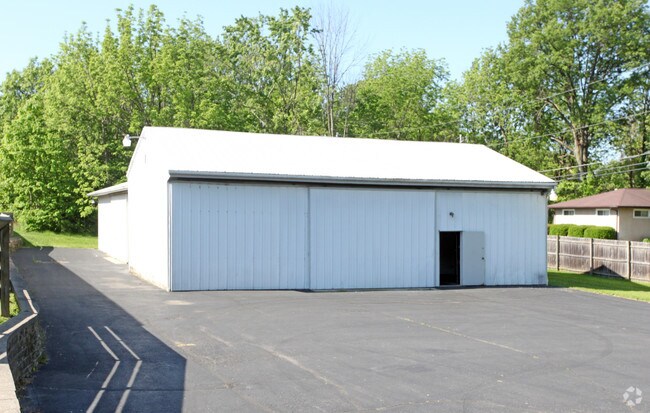
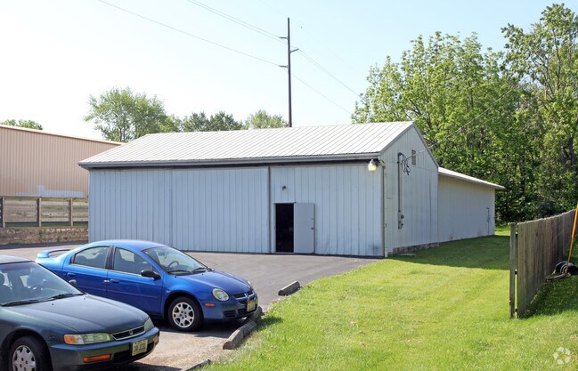
129 E College Ave
080-000686
129 COLLEGE AVE WESTERVILLE 0.714 ACRE
Officebuilding
FRANKLIN
B and X Area of moderate flood hazard, usually the area between the limits of the 100-year and 500-year floods.
Ohio
2024
0.71 AC
2025
Westerville
007020
Columbus
4,869 SF
Columbus, OH
NEARBY LISTINGS FOR SALE OR LEASE
DEMOGRAPHICS near 129 E College Ave
1 mile
3 mile
5 mile
2025 Total Population
11,429
86,938
237,088
2030 Population
11,761
90,138
246,682
Pop Growth 2025-2030
+ 2.90%
+ 3.68%
+ 4.05%
Average Age
40
40
38
2025 Total Households
4,260
34,532
94,215
HH Growth 2025-2030
+ 3.33%
+ 3.89%
+ 4.19%
Median Household Inc
$88,473
$94,555
$86,051
Avg Household Size
2.40
2.40
2.50
2025 Avg HH Vehicles
2.00
2.00
2.00
Median Home Value
$339,064
$359,984
$341,673
Median Year Built
1972
1983
1987
Nearby Places
Map Layers
Map Styles
 Street
 Aerial
Layers
 Traffic
 Biking
Places
Listings with unknown addresses are not visible on the map
- Restaurants
- Banks
- Shops
- Fitness
- Groceries
PUBLIC TRANSPORTATION
AIRPORT
John Glenn Columbus International
Drive
Walk
Distance
John Glenn Columbus International
21 min
12.3 mi
Rickenbacker International
Drive
Walk
Distance
Rickenbacker International
40 min
26.9 mi
Nearby Properties
Address
Land Use
TOTAL SIZE
Lot Size
Zoning
Address
Land Use
TOTAL SIZE
Lot Size
Zoning
440,828 SF
13.72 AC
Address
Land Use
TOTAL SIZE
Lot Size
Zoning
426,490 SF
19.43 AC
Address
Land Use
TOTAL SIZE
Lot Size
Zoning
446,516 SF
95.88 AC
Address
Land Use
TOTAL SIZE
Lot Size
Zoning
320,022 SF
37.14 AC
Address
Land Use
TOTAL SIZE
Lot Size
Zoning
697,077 SF
40.91 AC
Address
Land Use
TOTAL SIZE
Lot Size
Zoning
159,315 SF
13.25 AC
Address
Land Use
TOTAL SIZE
Lot Size
Zoning
218,891 SF
19.56 AC
Address
Land Use
TOTAL SIZE
Lot Size
Zoning
271,562 SF
5.79 AC
Address
Land Use
TOTAL SIZE
Lot Size
Zoning
354,123 SF
19.81 AC
Address
Land Use
TOTAL SIZE
Lot Size
Zoning
217,722 SF
67.75 AC
Address
Land Use
TOTAL SIZE
Lot Size
Zoning
169,697 SF
5.59 AC
Address
Land Use
TOTAL SIZE
Lot Size
Zoning
3,263 SF
989.66 AC
Address
Land Use
TOTAL SIZE
Lot Size
Zoning
134,311 SF
17.26 AC
Address
Land Use
TOTAL SIZE
Lot Size
Zoning
62,852 SF
15.56 AC
Address
Land Use
TOTAL SIZE
Lot Size
Zoning
201,072 SF
22.28 AC
Address
Land Use
TOTAL SIZE
Lot Size
Zoning
262,768 SF
4.35 AC
Address
Land Use
TOTAL SIZE
Lot Size
Zoning
292,377 SF
36.29 AC
Address
Land Use
TOTAL SIZE
Lot Size
Zoning
170,259 SF
16.30 AC
Address
Land Use
TOTAL SIZE
Lot Size
Zoning
137,489 SF
14.73 AC
Address
Land Use
TOTAL SIZE
Lot Size
Zoning
258,205 SF
5.13 AC
Address
Land Use
TOTAL SIZE
Lot Size
Zoning
249,112 SF
5.94 AC
Address
Land Use
TOTAL SIZE
Lot Size
Zoning
119,213 SF
25.43 AC
Address
Land Use
TOTAL SIZE
Lot Size
Zoning
140,337 SF
10.14 AC
Address
Land Use
TOTAL SIZE
Lot Size
Zoning
236,681 SF
7.83 AC
Address
Land Use
TOTAL SIZE
Lot Size
Zoning
217,703 SF
8.55 AC
Address
Land Use
TOTAL SIZE
Lot Size
Zoning
142,998 SF
30.25 AC
Address
Land Use
TOTAL SIZE
Lot Size
Zoning
100,848 SF
9.72 AC
Address
Land Use
TOTAL SIZE
Lot Size
Zoning
80,608 SF
7.34 AC
Address
Land Use
TOTAL SIZE
Lot Size
Zoning
28,068 SF
22.61 AC
Address
Land Use
TOTAL SIZE
Lot Size
Zoning
109,882 SF
15.13 AC
The World's #1 Commercial Real Estate Marketplace
Connect with us
© 2026 CoStar Group
The information above has been obtained from sources believed reliable. While we do not doubt its accuracy we have not verified it and make no guarantee, warranty or representation about it. It is your responsibility to independently confirm its accuracy and completeness. Any projections, opinions, assumptions, or estimates used are for example only and do not represent the current or future performance of the property. The value of this transaction to you depends on tax and other factors which should be evaluated by your tax, financial, and legal advisors. You and your advisors should conduct a careful, independent investigation of the property to determine to your satisfaction the suitability of the property for your needs.