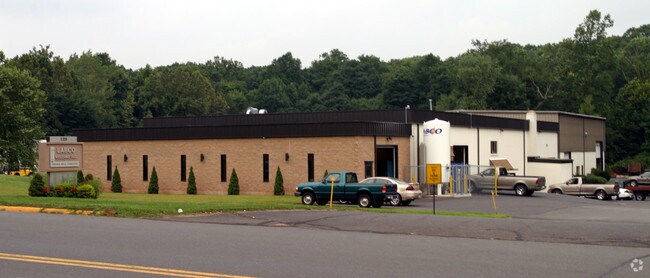
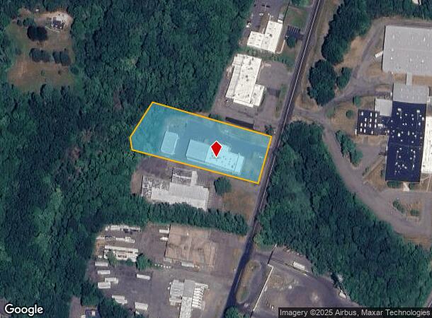
Property Record
129 Industrial Park Rd, Middletown, CT 06457
NEARBY LISTINGS FOR SALE OR LEASE
Property Detail
129 Industrial Park Rd
MTWN-000006-000000-000026
Middlesex
Industrialgeneral
Connecticut
AE
26
09003C0650F
2.53 AC
2024
NW Middlesex/Mid'town
2025
Hartford
541401
Hartford-West Hartford-East Hartford, CT
16,318 SF
DEMOGRAPHICS near 129 Industrial Park Rd
1 Mile
3 Mile
5 Mile
2024 Total Population
6,022
32,603
103,545
2029 Population
6,031
32,500
103,110
Pop Growth 2024-2029
+ 0.15%
(0.32%)
(0.42%)
Average Age
38
42
41
2024 Total Households
2,964
14,494
43,429
HH Growth 2024-2029
(0.17%)
(0.44%)
(0.40%)
Median Household Inc
$85,934
$89,982
$83,805
Avg Household Size
2.00
2.20
2.30
2024 Avg HH Vehicles
2.00
2.00
2.00
Median Home Value
$221,951
$285,314
$260,877
Median Year Built
1983
1980
1972
Nearby Places
Map Layers
Map Styles
 Street
 Aerial
- Restaurants
- Banks
- Shops
- Fitness
- Groceries
PUBLIC TRANSPORTATION
COMMUTER RAIL
DRIVE
WALK
Distance
11 min
5.3 mi
DRIVE
WALK
Distance
11 min
5.3 mi
AIRPORT
Tweed/New Haven
DRIVE
WALK
Distance
Tweed/New Haven
42 min
26.9 mi
Bradley International
DRIVE
WALK
Distance
Bradley International
44 min
28.9 mi
Freight Ports
Port of New Haven
DRIVE
WALK
Distance
Port of New Haven
36 min
25.7 mi
Nearby Properties
Address
Land Use
TOTAL SIZE
Lot Size
Zoning
Address
Land Use
TOTAL SIZE
Lot Size
Zoning
17.38 AC
PRD
Address
Land Use
TOTAL SIZE
Lot Size
Zoning
29.45 AC
R-15
Address
Land Use
TOTAL SIZE
Lot Size
Zoning
27.21 AC
M
Address
Land Use
TOTAL SIZE
Lot Size
Zoning
15.10 AC
PRD
Address
Land Use
TOTAL SIZE
Lot Size
Zoning
19.49 AC
PRD
Address
Land Use
TOTAL SIZE
Lot Size
Zoning
11.81 AC
PRD
Address
Land Use
TOTAL SIZE
Lot Size
Zoning
23.01 AC
M
Address
Land Use
TOTAL SIZE
Lot Size
Zoning
27,152 SF
8.75 AC
R-25
Address
Land Use
TOTAL SIZE
Lot Size
Zoning
24.45 AC
HB
Address
Land Use
TOTAL SIZE
Lot Size
Zoning
129,626 SF
22.36 AC
IT
Address
Land Use
TOTAL SIZE
Lot Size
Zoning
13.28 AC
PRD
Address
Land Use
TOTAL SIZE
Lot Size
Zoning
6.76 AC
M
Address
Land Use
TOTAL SIZE
Lot Size
Zoning
83,241 SF
52.65 AC
R-15
Address
Land Use
TOTAL SIZE
Lot Size
Zoning
41.78 AC
IT
Address
Land Use
TOTAL SIZE
Lot Size
Zoning
15.50 AC
PRD
Address
Land Use
TOTAL SIZE
Lot Size
Zoning
197,680 SF
26.91 AC
IT
Address
Land Use
TOTAL SIZE
Lot Size
Zoning
80,627 SF
10.54 AC
HB
Address
Land Use
TOTAL SIZE
Lot Size
Zoning
10.92 AC
B-2
Address
Land Use
TOTAL SIZE
Lot Size
Zoning
5.65 AC
HB
Address
Land Use
TOTAL SIZE
Lot Size
Zoning
37.25 AC
R-25
Address
Land Use
TOTAL SIZE
Lot Size
Zoning
13.02 AC
HB
Address
Land Use
TOTAL SIZE
Lot Size
Zoning
67,050 SF
20.36 AC
R-15
Address
Land Use
TOTAL SIZE
Lot Size
Zoning
14.65 AC
M
Address
Land Use
TOTAL SIZE
Lot Size
Zoning
50,533 SF
33 AC
R-30
Address
Land Use
TOTAL SIZE
Lot Size
Zoning
6.09 AC
PRD
Address
Land Use
TOTAL SIZE
Lot Size
Zoning
63,213 SF
5.32 AC
B-2
Address
Land Use
TOTAL SIZE
Lot Size
Zoning
72,920 SF
4.10 AC
HB
Address
Land Use
TOTAL SIZE
Lot Size
Zoning
122,735 SF
16.85 AC
HB
Address
Land Use
TOTAL SIZE
Lot Size
Zoning
49,228 SF
164.74 AC
R-1
Address
Land Use
TOTAL SIZE
Lot Size
Zoning
50,273 SF
16.20 AC
R-15
The World's #1 Commercial Real Estate Marketplace
Connect with us
© 2025 CoStar Group
The information above has been obtained from sources believed reliable. While we do not doubt its accuracy we have not verified it and make no guarantee, warranty or representation about it. It is your responsibility to independently confirm its accuracy and completeness. Any projections, opinions, assumptions, or estimates used are for example only and do not represent the current or future performance of the property. The value of this transaction to you depends on tax and other factors which should be evaluated by your tax, financial, and legal advisors. You and your advisors should conduct a careful, independent investigation of the property to determine to your satisfaction the suitability of the property for your needs.