Property Record
129 W 4Th St, Lorain, OH 44052
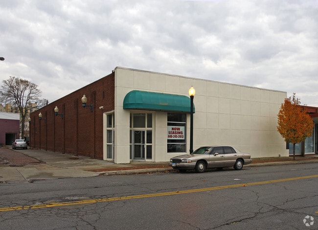

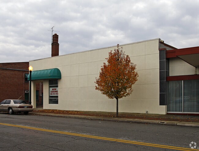
Property Detail
129 W 4Th St
Cleveland-Elyria, OH
O P C & VAC ALLEY FRNT 0068.00
02-01-005-107-006
Lorain
Commercialnec
Ohio
B and X Area of moderate flood hazard, usually the area between the limits of the 100-year and 500-year floods.
220
2024
0.23 AC
2024
Lorain County
022400
Cleveland
7,332 SF
NEARBY LISTINGS FOR SALE OR LEASE
DEMOGRAPHICS near 129 W 4Th St
1 mile
3 mile
5 mile
2025 Total Population
9,453
48,874
88,727
2030 Population
9,768
50,308
91,179
Pop Growth 2025-2030
+ 3.33%
+ 2.93%
+ 2.76%
Average Age
40
40
41
2025 Total Households
4,078
20,038
36,548
HH Growth 2025-2030
+ 3.43%
+ 2.95%
+ 2.79%
Median Household Inc
$34,332
$48,007
$54,347
Avg Household Size
2.10
2.30
2.30
2025 Avg HH Vehicles
1.00
2.00
2.00
Median Home Value
$96,432
$119,717
$152,705
Median Year Built
1947
1954
1961
Nearby Places
Map Layers
Map Styles
 Street
 Aerial
Transit
 Traffic
 Biking
Places
Listings with unknown addresses are not visible on the map
- Restaurants
- Banks
- Shops
- Fitness
- Groceries
PUBLIC TRANSPORTATION
AIRPORT
Cleveland-Hopkins International
Drive
Walk
Distance
Cleveland-Hopkins International
38 min
24.7 mi
Freight Ports
Port of Toledo
Drive
Walk
Distance
Port of Toledo
109 min
88.4 mi
SALE & LEASE HISTORY
LISTING DATE
SALE/LEASE

Jan 18, 2019
For Lease
Nearby Properties
Address
Land Use
TOTAL SIZE
Lot Size
Zoning
Address
Land Use
TOTAL SIZE
Lot Size
Zoning
83,865 SF
6.94 AC
Address
Land Use
TOTAL SIZE
Lot Size
Zoning
87,851 SF
15.44 AC
Address
Land Use
TOTAL SIZE
Lot Size
Zoning
53,266 SF
3 AC
Address
Land Use
TOTAL SIZE
Lot Size
Zoning
53,266 SF
13.30 AC
Address
Land Use
TOTAL SIZE
Lot Size
Zoning
52,392 SF
2.71 AC
Address
Land Use
TOTAL SIZE
Lot Size
Zoning
41,372 SF
2.42 AC
Address
Land Use
TOTAL SIZE
Lot Size
Zoning
43,773 SF
3.41 AC
Address
Land Use
TOTAL SIZE
Lot Size
Zoning
48,951 SF
15.71 AC
Address
Land Use
TOTAL SIZE
Lot Size
Zoning
191,168 SF
20.70 AC
Address
Land Use
TOTAL SIZE
Lot Size
Zoning
53,266 SF
12.90 AC
Address
Land Use
TOTAL SIZE
Lot Size
Zoning
115,497 SF
0.93 AC
Address
Land Use
TOTAL SIZE
Lot Size
Zoning
118,800 SF
1.01 AC
Address
Land Use
TOTAL SIZE
Lot Size
Zoning
1,887 SF
435.37 AC
Address
Land Use
TOTAL SIZE
Lot Size
Zoning
52,602 SF
9.31 AC
Address
Land Use
TOTAL SIZE
Lot Size
Zoning
72,753 SF
3.03 AC
Address
Land Use
TOTAL SIZE
Lot Size
Zoning
46,708 SF
8.56 AC
Address
Land Use
TOTAL SIZE
Lot Size
Zoning
99,979 SF
3.54 AC
Address
Land Use
TOTAL SIZE
Lot Size
Zoning
52,176 SF
0.31 AC
Address
Land Use
TOTAL SIZE
Lot Size
Zoning
29,029 SF
6.71 AC
Address
Land Use
TOTAL SIZE
Lot Size
Zoning
19,655 SF
0.56 AC
Address
Land Use
TOTAL SIZE
Lot Size
Zoning
Address
Land Use
TOTAL SIZE
Lot Size
Zoning
104,952 SF
12.49 AC
Address
Land Use
TOTAL SIZE
Lot Size
Zoning
Address
Land Use
TOTAL SIZE
Lot Size
Zoning
127,750 SF
8.37 AC
Address
Land Use
TOTAL SIZE
Lot Size
Zoning
25,056 SF
0.17 AC
Address
Land Use
TOTAL SIZE
Lot Size
Zoning
107,175 SF
3.30 AC
Address
Land Use
TOTAL SIZE
Lot Size
Zoning
3,992 SF
17.13 AC
Address
Land Use
TOTAL SIZE
Lot Size
Zoning
21,332 SF
2.16 AC
Address
Land Use
TOTAL SIZE
Lot Size
Zoning
29,681 SF
3.62 AC
Address
Land Use
TOTAL SIZE
Lot Size
Zoning
The World's #1 Commercial Real Estate Marketplace
Connect with us
© 2026 CoStar Group
The information above has been obtained from sources believed reliable. While we do not doubt its accuracy we have not verified it and make no guarantee, warranty or representation about it. It is your responsibility to independently confirm its accuracy and completeness. Any projections, opinions, assumptions, or estimates used are for example only and do not represent the current or future performance of the property. The value of this transaction to you depends on tax and other factors which should be evaluated by your tax, financial, and legal advisors. You and your advisors should conduct a careful, independent investigation of the property to determine to your satisfaction the suitability of the property for your needs.