Property Record
129 W Campbell Rd, Schenectady, NY 12306
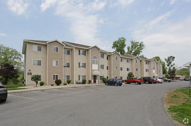

Property Detail
129 W Campbell Rd
048-000-0002-018-000-0000
SCHENECTADY
Apartment
New York
R-3
18.000
AE The base floodplain where base flood elevations are provided. AE Zones are now used on new format FIRMs instead of A1-A30 Zones.
26.11 AC
2025
Outer Schenectady County
2025
Albany/Schenectady/Troy
032700
Albany-Schenectady-Troy, NY
2,450 SF
NEARBY LISTINGS FOR SALE OR LEASE
DEMOGRAPHICS near 129 W Campbell Rd
1 mile
3 mile
5 mile
2025 Total Population
2,869
68,474
133,753
2030 Population
2,938
69,495
135,831
Pop Growth 2025-2030
+ 2.41%
+ 1.49%
+ 1.55%
Average Age
42
39
40
2025 Total Households
1,332
28,286
55,189
HH Growth 2025-2030
+ 2.78%
+ 1.68%
+ 1.70%
Median Household Inc
$75,959
$59,162
$69,426
Avg Household Size
2.10
2.20
2.30
2025 Avg HH Vehicles
2.00
1.00
2.00
Median Home Value
$204,086
$195,582
$225,474
Median Year Built
1959
1949
1952
Nearby Places
Map Layers
Map Styles
 Street
 Aerial
Layers
 Traffic
 Biking
Places
Listings with unknown addresses are not visible on the map
- Restaurants
- Banks
- Shops
- Fitness
- Groceries
PUBLIC TRANSPORTATION
AIRPORT
Albany International
Drive
Walk
Distance
Albany International
23 min
13.5 mi
Freight Ports
Albany, NY Port
Drive
Walk
Distance
Albany, NY Port
30 min
21.1 mi
Nearby Properties
Address
Land Use
TOTAL SIZE
Lot Size
Zoning
Address
Land Use
TOTAL SIZE
Lot Size
Zoning
2,068,862 SF
204.52 AC
I-2
Address
Land Use
TOTAL SIZE
Lot Size
Zoning
155,023 SF
18.81 AC
06 - INDUS
Address
Land Use
TOTAL SIZE
Lot Size
Zoning
6,733 SF
100 AC
03 - MULTI
Address
Land Use
TOTAL SIZE
Lot Size
Zoning
0.01 AC
06 - INDUS
Address
Land Use
TOTAL SIZE
Lot Size
Zoning
1,003,413 SF
177.60 AC
B-1, I-1
Address
Land Use
TOTAL SIZE
Lot Size
Zoning
246,000 SF
9.85 AC
Address
Land Use
TOTAL SIZE
Lot Size
Zoning
138,014 SF
4 AC
02 - SINGL
Address
Land Use
TOTAL SIZE
Lot Size
Zoning
59,240 SF
0.72 AC
05 - COMME
Address
Land Use
TOTAL SIZE
Lot Size
Zoning
306,803 SF
3.20 AC
Address
Land Use
TOTAL SIZE
Lot Size
Zoning
32,385 SF
5.02 AC
Address
Land Use
TOTAL SIZE
Lot Size
Zoning
284,171 SF
16.40 AC
03 - MULTI
Address
Land Use
TOTAL SIZE
Lot Size
Zoning
183,759 SF
1.40 AC
05 - COMME
Address
Land Use
TOTAL SIZE
Lot Size
Zoning
181,230 SF
1.02 AC
05 - COMME
Address
Land Use
TOTAL SIZE
Lot Size
Zoning
128,744 SF
119 AC
A-1
Address
Land Use
TOTAL SIZE
Lot Size
Zoning
9.38 AC
I-2
Address
Land Use
TOTAL SIZE
Lot Size
Zoning
152,503 SF
8.21 AC
I-1
Address
Land Use
TOTAL SIZE
Lot Size
Zoning
117,849 SF
5.76 AC
05 - COMME
Address
Land Use
TOTAL SIZE
Lot Size
Zoning
139,537 SF
5.10 AC
CON
Address
Land Use
TOTAL SIZE
Lot Size
Zoning
99.20 AC
Address
Land Use
TOTAL SIZE
Lot Size
Zoning
136,722 SF
2.01 AC
05 - COMME
Address
Land Use
TOTAL SIZE
Lot Size
Zoning
21,791 SF
4.93 AC
B-1, B-2
Address
Land Use
TOTAL SIZE
Lot Size
Zoning
141,145 SF
1.11 AC
05 - COMME
Address
Land Use
TOTAL SIZE
Lot Size
Zoning
21,791 SF
4.86 AC
B-1, B-2
Address
Land Use
TOTAL SIZE
Lot Size
Zoning
204,167 SF
33.90 AC
CON
Address
Land Use
TOTAL SIZE
Lot Size
Zoning
6,400 SF
18.20 AC
CON
Address
Land Use
TOTAL SIZE
Lot Size
Zoning
70,487 SF
2.51 AC
Address
Land Use
TOTAL SIZE
Lot Size
Zoning
12,572 SF
16.50 AC
CON
Address
Land Use
TOTAL SIZE
Lot Size
Zoning
12,289 SF
17.08 AC
R-3
Address
Land Use
TOTAL SIZE
Lot Size
Zoning
113,670 SF
1.35 AC
05 - COMME
Address
Land Use
TOTAL SIZE
Lot Size
Zoning
202,050 SF
20.75 AC
B-2
The World's #1 Commercial Real Estate Marketplace
Connect with us
© 2026 CoStar Group
The information above has been obtained from sources believed reliable. While we do not doubt its accuracy we have not verified it and make no guarantee, warranty or representation about it. It is your responsibility to independently confirm its accuracy and completeness. Any projections, opinions, assumptions, or estimates used are for example only and do not represent the current or future performance of the property. The value of this transaction to you depends on tax and other factors which should be evaluated by your tax, financial, and legal advisors. You and your advisors should conduct a careful, independent investigation of the property to determine to your satisfaction the suitability of the property for your needs.