Property Record
129 W Main St, Chester, CT 06412
NEARBY LISTINGS FOR SALE OR LEASE
Property Detail
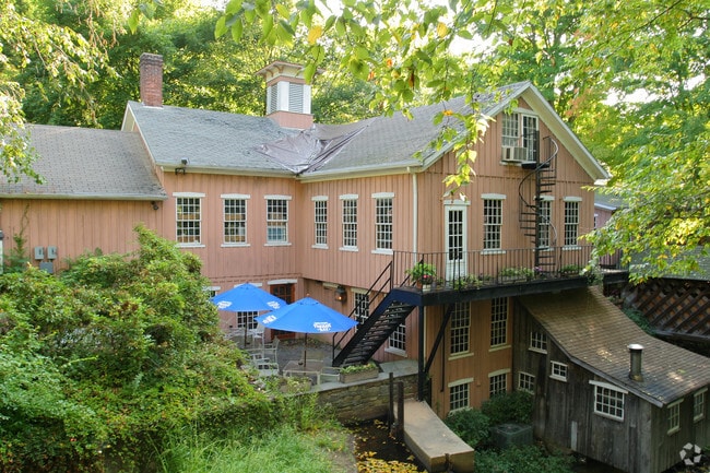
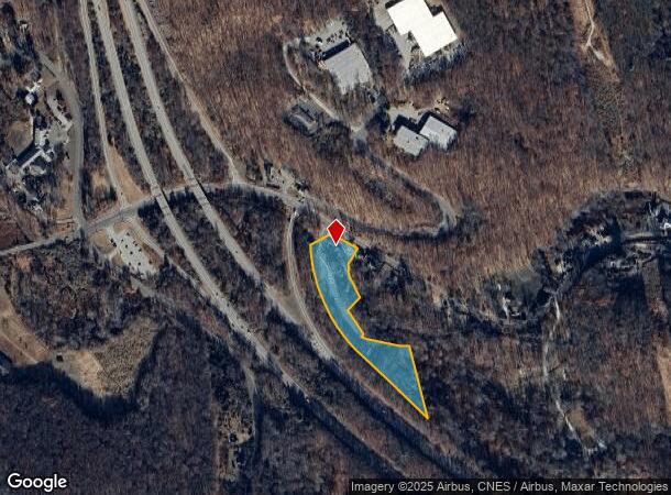
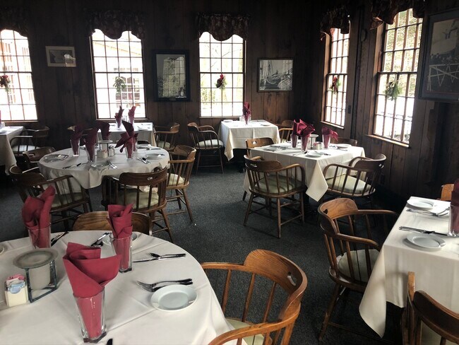
129 W Main St
Restaurantbuilding
Middlesex
AE
Connecticut
09007C0263G
3.90 AC
2025
SW Midlsx/Old Saybrk/Rt 9
2025
Hartford
600100
Hartford-West Hartford-East Hartford, CT
7,399 SF
CHES-000013-000000-000012
DEMOGRAPHICS near 129 W Main St
1 mile
3 mile
5 mile
2024 Total Population
1,052
7,020
18,274
2029 Population
1,046
6,996
18,214
Pop Growth 2024-2029
(0.57%)
(0.34%)
(0.33%)
Average Age
47
47
47
2024 Total Households
460
3,092
7,903
HH Growth 2024-2029
(0.65%)
(0.52%)
(0.49%)
Median Household Inc
$102,932
$91,778
$99,886
Avg Household Size
2.20
2.20
2.20
2024 Avg HH Vehicles
2.00
2.00
2.00
Median Home Value
$361,573
$330,734
$356,134
Median Year Built
1949
1962
1968
Nearby Places
Map Layers
Map Styles
 Street
 Aerial
Transit
 Traffic
 Biking
Places
Listings with unknown addresses are not visible on the map
- Restaurants
- Banks
- Shops
- Fitness
- Groceries
PUBLIC TRANSPORTATION
COMMUTER RAIL
Old Saybrook (Shore Line East - Shore Line East)
Drive
Walk
Distance
Old Saybrook (Shore Line East - Shore Line East)
14 min
9.5 mi
Drive
Walk
Distance
16 min
9.9 mi
AIRPORT
Tweed/New Haven
Drive
Walk
Distance
Tweed/New Haven
47 min
31.6 mi
SALE & LEASE HISTORY
LISTING DATE
SALE/LEASE

May 31, 2017
For Sale
Dec 12, 2019
For Sale
Nearby Properties
Address
Land Use
TOTAL SIZE
Lot Size
Zoning
Address
Land Use
TOTAL SIZE
Lot Size
Zoning
66.05 AC
PRD
Address
Land Use
TOTAL SIZE
Lot Size
Zoning
38.67 AC
R60
Address
Land Use
TOTAL SIZE
Lot Size
Zoning
50,026 SF
12.87 AC
R-1
Address
Land Use
TOTAL SIZE
Lot Size
Zoning
7.60 AC
VRD
Address
Land Use
TOTAL SIZE
Lot Size
Zoning
52,000 SF
17.96 AC
RLM
Address
Land Use
TOTAL SIZE
Lot Size
Zoning
18.75 AC
Address
Land Use
TOTAL SIZE
Lot Size
Zoning
43,023 SF
1.08 AC
GCD
Address
Land Use
TOTAL SIZE
Lot Size
Zoning
23.16 AC
Address
Land Use
TOTAL SIZE
Lot Size
Zoning
16,008 SF
1.50 AC
C
Address
Land Use
TOTAL SIZE
Lot Size
Zoning
84.30 AC
R60
Address
Land Use
TOTAL SIZE
Lot Size
Zoning
18.49 AC
HDD
Address
Land Use
TOTAL SIZE
Lot Size
Zoning
18.90 AC
WD2
Address
Land Use
TOTAL SIZE
Lot Size
Zoning
7,152 SF
122.42 AC
RLM
Address
Land Use
TOTAL SIZE
Lot Size
Zoning
151,159 SF
6.30 AC
VID
Address
Land Use
TOTAL SIZE
Lot Size
Zoning
30.70 AC
Address
Land Use
TOTAL SIZE
Lot Size
Zoning
13,739 SF
0.65 AC
VCD
Address
Land Use
TOTAL SIZE
Lot Size
Zoning
14,016 SF
16.03 AC
R-1
Address
Land Use
TOTAL SIZE
Lot Size
Zoning
6,371 SF
2.76 AC
Address
Land Use
TOTAL SIZE
Lot Size
Zoning
44.17 AC
R-2
Address
Land Use
TOTAL SIZE
Lot Size
Zoning
146,466 SF
13.55 AC
VID
Address
Land Use
TOTAL SIZE
Lot Size
Zoning
22.26 AC
R-1
Address
Land Use
TOTAL SIZE
Lot Size
Zoning
27,225 SF
2.45 AC
VCD
Address
Land Use
TOTAL SIZE
Lot Size
Zoning
63,938 SF
9.79 AC
CDD
Address
Land Use
TOTAL SIZE
Lot Size
Zoning
19.27 AC
R-2
Address
Land Use
TOTAL SIZE
Lot Size
Zoning
14,382 SF
1.87 AC
VMU
Address
Land Use
TOTAL SIZE
Lot Size
Zoning
50.35 AC
CIP
Address
Land Use
TOTAL SIZE
Lot Size
Zoning
15.70 AC
WD2
Address
Land Use
TOTAL SIZE
Lot Size
Zoning
6,978 SF
164.08 AC
R-2
Address
Land Use
TOTAL SIZE
Lot Size
Zoning
10,583 SF
0.29 AC
VCD
Address
Land Use
TOTAL SIZE
Lot Size
Zoning
2.76 AC
R30
The World's #1 Commercial Real Estate Marketplace
Connect with us
© 2026 CoStar Group
The information above has been obtained from sources believed reliable. While we do not doubt its accuracy we have not verified it and make no guarantee, warranty or representation about it. It is your responsibility to independently confirm its accuracy and completeness. Any projections, opinions, assumptions, or estimates used are for example only and do not represent the current or future performance of the property. The value of this transaction to you depends on tax and other factors which should be evaluated by your tax, financial, and legal advisors. You and your advisors should conduct a careful, independent investigation of the property to determine to your satisfaction the suitability of the property for your needs.