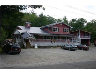
Property Record
129 W Shore Rd, Otis, MA 01253


NEARBY LISTINGS FOR SALE OR LEASE
Property Detail
129 W Shore Rd
Pittsfield, MA
Berkshire
OTIS-000015-000000-000075
Massachusetts
Commercialofficeresidentialmixeduse
75
2025
1 AC
2025
Massachusetts North/West Area
933400
Other Market Areas
4,016 SF
DEMOGRAPHICS near 129 W Shore Rd
1 Mile
3 Mile
5 Mile
2024 Total Population
230
938
1,760
2029 Population
214
895
1,719
Pop Growth 2024-2029
(6.96%)
(4.58%)
(2.33%)
Average Age
52
51
50
2024 Total Households
110
437
806
HH Growth 2024-2029
(7.27%)
(4.81%)
(2.61%)
Median Household Inc
$90,277
$89,999
$87,703
Avg Household Size
2.10
2.10
2.20
2024 Avg HH Vehicles
2.00
2.00
2.00
Median Home Value
$305,882
$305,195
$303,437
Median Year Built
1969
1971
1973
Nearby Places
Map Layers
Map Styles
 Street
 Aerial
- Restaurants
- Banks
- Shops
- Fitness
- Groceries
PUBLIC TRANSPORTATION
AIRPORT
Bradley International
DRIVE
WALK
Distance
Bradley International
69 min
35.2 mi
Freight Ports
Albany, NY Port
DRIVE
WALK
Distance
Albany, NY Port
81 min
59.9 mi
SALE & LEASE HISTORY
LISTING DATE
SALE/LEASE

Sep 28, 2022
For Sale
Nearby Properties
Address
Land Use
TOTAL SIZE
Lot Size
Zoning
Address
Land Use
TOTAL SIZE
Lot Size
Zoning
0.57 AC
R40
Address
Land Use
TOTAL SIZE
Lot Size
Zoning
3,049 SF
1.46 AC
R40
Address
Land Use
TOTAL SIZE
Lot Size
Zoning
15,432 SF
1.60 AC
V-1
Address
Land Use
TOTAL SIZE
Lot Size
Zoning
116.52 AC
R40
Address
Land Use
TOTAL SIZE
Lot Size
Zoning
0.54 AC
R40
Address
Land Use
TOTAL SIZE
Lot Size
Zoning
2,329 SF
0.39 AC
R1
Address
Land Use
TOTAL SIZE
Lot Size
Zoning
0.28 AC
R40
Address
Land Use
TOTAL SIZE
Lot Size
Zoning
1,506 SF
0.53 AC
R1
Address
Land Use
TOTAL SIZE
Lot Size
Zoning
1.25 AC
R40
Address
Land Use
TOTAL SIZE
Lot Size
Zoning
821.80 AC
1
Address
Land Use
TOTAL SIZE
Lot Size
Zoning
1,410 AC
R1
Address
Land Use
TOTAL SIZE
Lot Size
Zoning
0.60 AC
R40
Address
Land Use
TOTAL SIZE
Lot Size
Zoning
0.54 AC
R40
Address
Land Use
TOTAL SIZE
Lot Size
Zoning
1,594 SF
129.65 AC
R40
Address
Land Use
TOTAL SIZE
Lot Size
Zoning
732 AC
R1
Address
Land Use
TOTAL SIZE
Lot Size
Zoning
2,660 SF
1.66 AC
R40
Address
Land Use
TOTAL SIZE
Lot Size
Zoning
84.03 AC
R40
Address
Land Use
TOTAL SIZE
Lot Size
Zoning
853.80 AC
R40
Address
Land Use
TOTAL SIZE
Lot Size
Zoning
1,200 SF
0.82 AC
R1
Address
Land Use
TOTAL SIZE
Lot Size
Zoning
6,352 SF
7.35 AC
V-1
Address
Land Use
TOTAL SIZE
Lot Size
Zoning
1,717 SF
117.64 AC
1
Address
Land Use
TOTAL SIZE
Lot Size
Zoning
0.29 AC
R40
Address
Land Use
TOTAL SIZE
Lot Size
Zoning
1 AC
R40
Address
Land Use
TOTAL SIZE
Lot Size
Zoning
1 AC
R40
Address
Land Use
TOTAL SIZE
Lot Size
Zoning
6.01 AC
R40
Address
Land Use
TOTAL SIZE
Lot Size
Zoning
15.07 AC
R-1A
Address
Land Use
TOTAL SIZE
Lot Size
Zoning
3,906 SF
4.05 AC
R40
Address
Land Use
TOTAL SIZE
Lot Size
Zoning
187 AC
1
Address
Land Use
TOTAL SIZE
Lot Size
Zoning
2.64 AC
V-1
Address
Land Use
TOTAL SIZE
Lot Size
Zoning
800 SF
0.24 AC
R40
The World's #1 Commercial Real Estate Marketplace
Connect with us
© 2026 CoStar Group
The information above has been obtained from sources believed reliable. While we do not doubt its accuracy we have not verified it and make no guarantee, warranty or representation about it. It is your responsibility to independently confirm its accuracy and completeness. Any projections, opinions, assumptions, or estimates used are for example only and do not represent the current or future performance of the property. The value of this transaction to you depends on tax and other factors which should be evaluated by your tax, financial, and legal advisors. You and your advisors should conduct a careful, independent investigation of the property to determine to your satisfaction the suitability of the property for your needs.