Property Record
1290 River Rd, New Braunfels, TX 78130
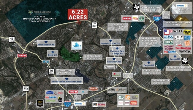

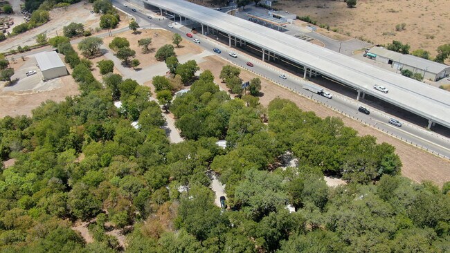
Property Detail
1290 River Rd
70-0002-0005-00
A- 2 SUR- 1 J M VERAMENDI, ACRES 6.6155
Commercialnec
Comal
AE The base floodplain where base flood elevations are provided. AE Zones are now used on new format FIRMs instead of A1-A30 Zones.
Texas
2024
6.62 AC
2025
Comal County
310302
San Antonio
740 SF
San Antonio-New Braunfels, TX
NEARBY LISTINGS FOR SALE OR LEASE
DEMOGRAPHICS near 1290 River Rd
1 mile
3 mile
5 mile
2025 Total Population
5,181
47,392
106,155
2030 Population
6,098
55,775
123,827
Pop Growth 2025-2030
+ 17.70%
+ 17.69%
+ 16.65%
Average Age
43
41
39
2025 Total Households
2,312
19,630
40,818
HH Growth 2025-2030
+ 17.73%
+ 17.75%
+ 16.96%
Median Household Inc
$65,343
$79,806
$89,081
Avg Household Size
2.10
2.30
2.50
2025 Avg HH Vehicles
2.00
2.00
2.00
Median Home Value
$480,755
$432,240
$372,635
Median Year Built
1990
1998
2006
Nearby Places
Map Layers
Map Styles
 Street
 Aerial
Transit
 Traffic
 Biking
Places
Listings with unknown addresses are not visible on the map
- Restaurants
- Banks
- Shops
- Fitness
- Groceries
PUBLIC TRANSPORTATION
AIRPORT
San Antonio International
Drive
Walk
Distance
San Antonio International
37 min
29.0 mi
Freight Ports
Calhoun Port
Drive
Walk
Distance
Calhoun Port
172 min
145.8 mi
SALE & LEASE HISTORY
LISTING DATE
SALE/LEASE

Sep 08, 2022
For Sale
Mar 07, 2025
For Sale
Dec 19, 2023
For Sale
Apr 08, 2022
For Sale
Nearby Properties
Address
Land Use
TOTAL SIZE
Lot Size
Zoning
Address
Land Use
TOTAL SIZE
Lot Size
Zoning
111.44 AC
Address
Land Use
TOTAL SIZE
Lot Size
Zoning
350,595 SF
21.78 AC
Address
Land Use
TOTAL SIZE
Lot Size
Zoning
304,097 SF
14.98 AC
Address
Land Use
TOTAL SIZE
Lot Size
Zoning
292,822 SF
12.29 AC
Address
Land Use
TOTAL SIZE
Lot Size
Zoning
248,377 SF
23.66 AC
Address
Land Use
TOTAL SIZE
Lot Size
Zoning
433,083 SF
16.24 AC
Address
Land Use
TOTAL SIZE
Lot Size
Zoning
251,498 SF
8.63 AC
Address
Land Use
TOTAL SIZE
Lot Size
Zoning
381,528 SF
82.50 AC
Address
Land Use
TOTAL SIZE
Lot Size
Zoning
325,518 SF
12.97 AC
Address
Land Use
TOTAL SIZE
Lot Size
Zoning
225,158 SF
52.63 AC
Address
Land Use
TOTAL SIZE
Lot Size
Zoning
271,410 SF
13.13 AC
Address
Land Use
TOTAL SIZE
Lot Size
Zoning
319,423 SF
14.59 AC
Address
Land Use
TOTAL SIZE
Lot Size
Zoning
170,266 SF
16.78 AC
Address
Land Use
TOTAL SIZE
Lot Size
Zoning
261,155 SF
11.57 AC
Address
Land Use
TOTAL SIZE
Lot Size
Zoning
269,288 SF
16.32 AC
Address
Land Use
TOTAL SIZE
Lot Size
Zoning
229,773 SF
11.18 AC
Address
Land Use
TOTAL SIZE
Lot Size
Zoning
103,782 SF
105.82 AC
Address
Land Use
TOTAL SIZE
Lot Size
Zoning
215,244 SF
11.38 AC
Address
Land Use
TOTAL SIZE
Lot Size
Zoning
282,995 SF
21.83 AC
Address
Land Use
TOTAL SIZE
Lot Size
Zoning
238,683 SF
9.42 AC
Address
Land Use
TOTAL SIZE
Lot Size
Zoning
186,838 SF
14.53 AC
Address
Land Use
TOTAL SIZE
Lot Size
Zoning
102,856 SF
16.06 AC
Address
Land Use
TOTAL SIZE
Lot Size
Zoning
145,856 SF
9.52 AC
Address
Land Use
TOTAL SIZE
Lot Size
Zoning
88,620 SF
10.11 AC
Address
Land Use
TOTAL SIZE
Lot Size
Zoning
163,226 SF
29.14 AC
Address
Land Use
TOTAL SIZE
Lot Size
Zoning
152,240 SF
14.13 AC
Address
Land Use
TOTAL SIZE
Lot Size
Zoning
170,019 SF
4.46 AC
Address
Land Use
TOTAL SIZE
Lot Size
Zoning
3,937 SF
87.21 AC
Address
Land Use
TOTAL SIZE
Lot Size
Zoning
179,869 SF
10 AC
Address
Land Use
TOTAL SIZE
Lot Size
Zoning
188,600 SF
4.61 AC
The World's #1 Commercial Real Estate Marketplace
Connect with us
© 2026 CoStar Group
The information above has been obtained from sources believed reliable. While we do not doubt its accuracy we have not verified it and make no guarantee, warranty or representation about it. It is your responsibility to independently confirm its accuracy and completeness. Any projections, opinions, assumptions, or estimates used are for example only and do not represent the current or future performance of the property. The value of this transaction to you depends on tax and other factors which should be evaluated by your tax, financial, and legal advisors. You and your advisors should conduct a careful, independent investigation of the property to determine to your satisfaction the suitability of the property for your needs.