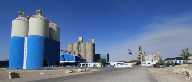
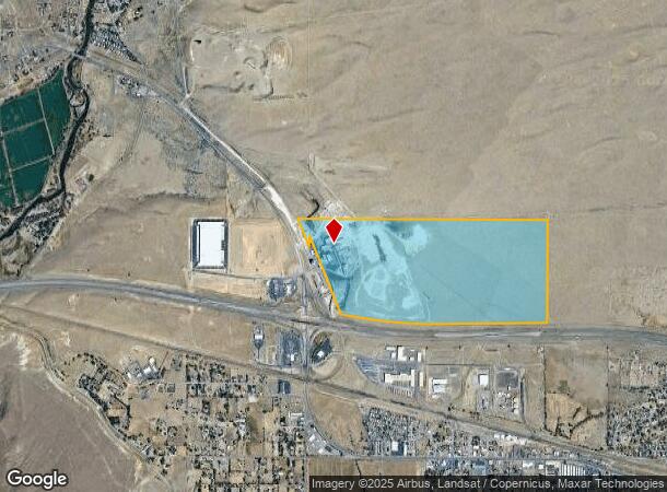
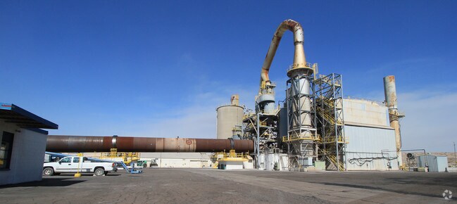
Property Record
1290 W Main St, Fernley, NV 89408
NEARBY LISTINGS FOR SALE OR LEASE
-
-
View all Fernley listings for sale on LoopNet.com
Property Detail
1290 W Main St
021-042-01
11-20-24 FR N 1/2
Transportationcommunicationsgeneral
Lyon
X
Nevada
32031C3135G
267.40 AC
2026
Fernley
2025
Reno/Sparks
960106
Fernley, NV
DEMOGRAPHICS near 1290 W Main St
1 Mile
3 Mile
5 Mile
2024 Total Population
587
13,118
20,874
2029 Population
655
14,396
22,950
Pop Growth 2024-2029
+ 11.58%
+ 9.74%
+ 9.95%
Average Age
40
39
38
2024 Total Households
226
4,882
7,480
HH Growth 2024-2029
+ 11.95%
+ 9.77%
+ 9.95%
Median Household Inc
$68,478
$80,661
$81,818
Avg Household Size
2.50
2.70
2.80
2024 Avg HH Vehicles
2.00
2.00
2.00
Median Home Value
$278,888
$282,566
$320,601
Median Year Built
1987
1995
2000
Nearby Places
Map Layers
Map Styles
 Street
 Aerial
- Restaurants
- Banks
- Shops
- Fitness
- Groceries
PUBLIC TRANSPORTATION
AIRPORT
Reno/Tahoe International
DRIVE
WALK
Distance
Reno/Tahoe International
58 min
37.5 mi
Freight Ports
Port of Stockton
DRIVE
WALK
Distance
Port of Stockton
242 min
211.8 mi
Nearby Properties
Address
Land Use
TOTAL SIZE
Lot Size
Zoning
Address
Land Use
TOTAL SIZE
Lot Size
Zoning
28.88 AC
RR1
Address
Land Use
TOTAL SIZE
Lot Size
Zoning
465,120 SF
24.16 AC
I
Address
Land Use
TOTAL SIZE
Lot Size
Zoning
8,799 SF
11.67 AC
MF30
Address
Land Use
TOTAL SIZE
Lot Size
Zoning
588,560 SF
34.94 AC
MULT
Address
Land Use
TOTAL SIZE
Lot Size
Zoning
112,125 SF
57.15 AC
GR20
Address
Land Use
TOTAL SIZE
Lot Size
Zoning
172,724 SF
22.27 AC
I
Address
Land Use
TOTAL SIZE
Lot Size
Zoning
157,615 SF
16.36 AC
C2
Address
Land Use
TOTAL SIZE
Lot Size
Zoning
128,409 SF
13.14 AC
C2
Address
Land Use
TOTAL SIZE
Lot Size
Zoning
4,000 SF
34.40 AC
I
Address
Land Use
TOTAL SIZE
Lot Size
Zoning
20,935 SF
29.04 AC
MULT
Address
Land Use
TOTAL SIZE
Lot Size
Zoning
54,726 SF
10 AC
RR1
Address
Land Use
TOTAL SIZE
Lot Size
Zoning
4,474 SF
6.23 AC
PF
Address
Land Use
TOTAL SIZE
Lot Size
Zoning
52,100 SF
4.91 AC
C2
Address
Land Use
TOTAL SIZE
Lot Size
Zoning
115,200 SF
6.18 AC
I
Address
Land Use
TOTAL SIZE
Lot Size
Zoning
20,357 SF
74.69 AC
A
Address
Land Use
TOTAL SIZE
Lot Size
Zoning
111,142 SF
19.32 AC
I
Address
Land Use
TOTAL SIZE
Lot Size
Zoning
19,714 SF
6.98 AC
TC
Address
Land Use
TOTAL SIZE
Lot Size
Zoning
45,666 SF
5.92 AC
C2
Address
Land Use
TOTAL SIZE
Lot Size
Zoning
29,972 SF
4.76 AC
PF
Address
Land Use
TOTAL SIZE
Lot Size
Zoning
44,589 SF
1.95 AC
C2
Address
Land Use
TOTAL SIZE
Lot Size
Zoning
9,360 SF
3.48 AC
I
Address
Land Use
TOTAL SIZE
Lot Size
Zoning
33,840 SF
11.98 AC
I
Address
Land Use
TOTAL SIZE
Lot Size
Zoning
1,992 SF
6.01 AC
MULT
Address
Land Use
TOTAL SIZE
Lot Size
Zoning
25,624 SF
2.81 AC
MULT
Address
Land Use
TOTAL SIZE
Lot Size
Zoning
10,645 SF
10.03 AC
C2
Address
Land Use
TOTAL SIZE
Lot Size
Zoning
6,476 SF
3.44 AC
MF30
Address
Land Use
TOTAL SIZE
Lot Size
Zoning
18,694 SF
2.55 AC
PF
Address
Land Use
TOTAL SIZE
Lot Size
Zoning
13,851 SF
3.30 AC
C2
Address
Land Use
TOTAL SIZE
Lot Size
Zoning
10,308 SF
9.07 AC
C2
The World's #1 Commercial Real Estate Marketplace
Connect with us
© 2025 CoStar Group
The information above has been obtained from sources believed reliable. While we do not doubt its accuracy we have not verified it and make no guarantee, warranty or representation about it. It is your responsibility to independently confirm its accuracy and completeness. Any projections, opinions, assumptions, or estimates used are for example only and do not represent the current or future performance of the property. The value of this transaction to you depends on tax and other factors which should be evaluated by your tax, financial, and legal advisors. You and your advisors should conduct a careful, independent investigation of the property to determine to your satisfaction the suitability of the property for your needs.