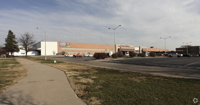
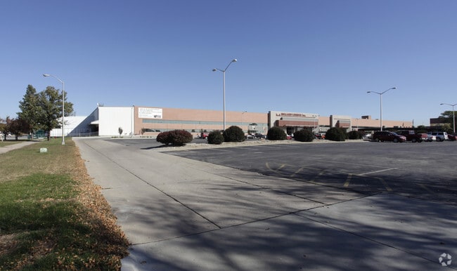
Property Record
12900 I St, Omaha, NE 68137

Property Detail
12900 I St
Omaha, NE-IA
OMAHA WORKS INDUSTRIAL PARK REP 13 LOT 2 BLOCK 0 -EX IRR S 317.9 FT FOR S 130 PLZ- LOT 2 32.754 AC
2011-0652-19
DOUGLAS
Warehouse
Nebraska
B and X Area of moderate flood hazard, usually the area between the limits of the 100-year and 500-year floods.
2
2024
33.06 AC
2025
Southwest Omaha
007409
Omaha/Council Bluffs
611,001 SF
NEARBY LISTINGS FOR SALE OR LEASE
DEMOGRAPHICS near 12900 I St
1 mile
3 mile
5 mile
2025 Total Population
8,632
83,811
226,803
2030 Population
8,776
85,565
233,061
Pop Growth 2025-2030
+ 1.67%
+ 2.09%
+ 2.76%
Average Age
39
40
40
2025 Total Households
3,725
34,672
93,013
HH Growth 2025-2030
+ 1.91%
+ 2.32%
+ 2.94%
Median Household Inc
$67,466
$84,021
$91,620
Avg Household Size
2.20
2.30
2.40
2025 Avg HH Vehicles
2.00
2.00
2.00
Median Home Value
$206,313
$266,029
$300,939
Median Year Built
1968
1977
1983
Nearby Places
Map Layers
Map Styles
 Street
 Aerial
Layers
 Traffic
 Biking
Places
Listings with unknown addresses are not visible on the map
- Restaurants
- Banks
- Shops
- Fitness
- Groceries
PUBLIC TRANSPORTATION
AIRPORT
Eppley Airfield
Drive
Walk
Distance
Eppley Airfield
28 min
16.5 mi
Freight Ports
Tulsa Port Of Catoosa
Drive
Walk
Distance
Tulsa Port Of Catoosa
474 min
425.6 mi
SALE & LEASE HISTORY
LISTING DATE
SALE/LEASE

Sep 25, 2016
For Lease
May 20, 2025
For Lease
Mar 12, 2018
For Lease
Aug 04, 2022
For Lease
Nearby Properties
Address
Land Use
TOTAL SIZE
Lot Size
Zoning
Address
Land Use
TOTAL SIZE
Lot Size
Zoning
3,654 SF
39.62 AC
Address
Land Use
TOTAL SIZE
Lot Size
Zoning
209,917 SF
9.52 AC
Address
Land Use
TOTAL SIZE
Lot Size
Zoning
370,890 SF
11.20 AC
CC
Address
Land Use
TOTAL SIZE
Lot Size
Zoning
503,886 SF
25.40 AC
Address
Land Use
TOTAL SIZE
Lot Size
Zoning
56,174 SF
8.65 AC
Address
Land Use
TOTAL SIZE
Lot Size
Zoning
410,657 SF
18.25 AC
Address
Land Use
TOTAL SIZE
Lot Size
Zoning
252,985 SF
6.53 AC
Address
Land Use
TOTAL SIZE
Lot Size
Zoning
369,614 SF
18.03 AC
CC
Address
Land Use
TOTAL SIZE
Lot Size
Zoning
130,286 SF
4.31 AC
GO
Address
Land Use
TOTAL SIZE
Lot Size
Zoning
294,334 SF
19.14 AC
R6
Address
Land Use
TOTAL SIZE
Lot Size
Zoning
85,632 SF
5.69 AC
Address
Land Use
TOTAL SIZE
Lot Size
Zoning
282,180 SF
13.96 AC
Address
Land Use
TOTAL SIZE
Lot Size
Zoning
897,738 SF
52.16 AC
Address
Land Use
TOTAL SIZE
Lot Size
Zoning
23,890 SF
14.34 AC
I2
Address
Land Use
TOTAL SIZE
Lot Size
Zoning
329,515 SF
6.37 AC
Address
Land Use
TOTAL SIZE
Lot Size
Zoning
354,299 SF
22.85 AC
R6
Address
Land Use
TOTAL SIZE
Lot Size
Zoning
423,905 SF
21.96 AC
GI
Address
Land Use
TOTAL SIZE
Lot Size
Zoning
281,964 SF
18.15 AC
R6
Address
Land Use
TOTAL SIZE
Lot Size
Zoning
274,072 SF
12.06 AC
Address
Land Use
TOTAL SIZE
Lot Size
Zoning
271,404 SF
17.51 AC
Address
Land Use
TOTAL SIZE
Lot Size
Zoning
268,545 SF
7.53 AC
Address
Land Use
TOTAL SIZE
Lot Size
Zoning
124,820 SF
9.69 AC
MU
Address
Land Use
TOTAL SIZE
Lot Size
Zoning
286,445 SF
16.18 AC
R6
Address
Land Use
TOTAL SIZE
Lot Size
Zoning
238,428 SF
18.64 AC
R5
Address
Land Use
TOTAL SIZE
Lot Size
Zoning
154,164 SF
13.33 AC
Address
Land Use
TOTAL SIZE
Lot Size
Zoning
211,228 SF
4.79 AC
Address
Land Use
TOTAL SIZE
Lot Size
Zoning
201,293 SF
4.71 AC
Address
Land Use
TOTAL SIZE
Lot Size
Zoning
128,497 SF
13.49 AC
Address
Land Use
TOTAL SIZE
Lot Size
Zoning
12,998 SF
15.63 AC
The World's #1 Commercial Real Estate Marketplace
Connect with us
© 2026 CoStar Group
The information above has been obtained from sources believed reliable. While we do not doubt its accuracy we have not verified it and make no guarantee, warranty or representation about it. It is your responsibility to independently confirm its accuracy and completeness. Any projections, opinions, assumptions, or estimates used are for example only and do not represent the current or future performance of the property. The value of this transaction to you depends on tax and other factors which should be evaluated by your tax, financial, and legal advisors. You and your advisors should conduct a careful, independent investigation of the property to determine to your satisfaction the suitability of the property for your needs.