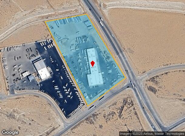
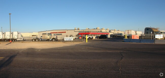
Property Record
12901 I40 West Frontage Rd Nw, Albuquerque, NM 87121

NEARBY LISTINGS FOR SALE OR LEASE
-
-
View all Albuquerque listings for sale on LoopNet.com
Property Detail
12901 I40 West Frontage Rd Nw
1-006-056-225375-2-03-06
J & W Addition
Autorepair
TRACT 113A1-A PLAT OF TRACT 113A1-A NINE MILE HILL NORTHEAST CONT 9.4150 AC
X
Bernalillo
35001C0308H
New Mexico
2024
9.41 AC
2025
West Mesa
940602
Albuquerque
39,800 SF
Albuquerque, NM
DEMOGRAPHICS near 12901 I40 West Frontage Rd Nw
1 Mile
3 Mile
5 Mile
2024 Total Population
2,075
17,661
86,618
2029 Population
2,129
17,451
85,707
Pop Growth 2024-2029
+ 2.60%
(1.19%)
(1.05%)
Average Age
30
35
35
2024 Total Households
556
5,425
28,087
HH Growth 2024-2029
+ 2.34%
(1.40%)
(1.19%)
Median Household Inc
$38,656
$57,412
$56,794
Avg Household Size
3.50
3.10
3.00
2024 Avg HH Vehicles
2.00
2.00
2.00
Median Home Value
$89,188
$159,518
$175,897
Median Year Built
1993
1997
2000
Nearby Places
Map Layers
Map Styles
 Street
 Aerial
- Restaurants
- Banks
- Shops
- Fitness
- Groceries
PUBLIC TRANSPORTATION
AIRPORT
Albuquerque International Sunport
DRIVE
WALK
Distance
Albuquerque International Sunport
34 min
20.1 mi
Freight Ports
Port of San Diego
DRIVE
WALK
Distance
Port of San Diego
849 min
800.1 mi
Nearby Properties
Address
Land Use
TOTAL SIZE
Lot Size
Zoning
Address
Land Use
TOTAL SIZE
Lot Size
Zoning
2,564,809 SF
72.07 AC
Address
Land Use
TOTAL SIZE
Lot Size
Zoning
755,293 SF
49.94 AC
Address
Land Use
TOTAL SIZE
Lot Size
Zoning
Address
Land Use
TOTAL SIZE
Lot Size
Zoning
Address
Land Use
TOTAL SIZE
Lot Size
Zoning
278,022 SF
38.02 AC
Address
Land Use
TOTAL SIZE
Lot Size
Zoning
201,339 SF
45.06 AC
Address
Land Use
TOTAL SIZE
Lot Size
Zoning
79,080 SF
50.15 AC
Address
Land Use
TOTAL SIZE
Lot Size
Zoning
4,564 SF
102.91 AC
Address
Land Use
TOTAL SIZE
Lot Size
Zoning
40,880 SF
10.03 AC
Address
Land Use
TOTAL SIZE
Lot Size
Zoning
65,527 SF
24.99 AC
Address
Land Use
TOTAL SIZE
Lot Size
Zoning
34,880 SF
4 AC
Address
Land Use
TOTAL SIZE
Lot Size
Zoning
19,873 SF
15.96 AC
Address
Land Use
TOTAL SIZE
Lot Size
Zoning
Address
Land Use
TOTAL SIZE
Lot Size
Zoning
9,700 SF
4.79 AC
Address
Land Use
TOTAL SIZE
Lot Size
Zoning
5,262 SF
15.61 AC
Address
Land Use
TOTAL SIZE
Lot Size
Zoning
4,703 SF
24.52 AC
Address
Land Use
TOTAL SIZE
Lot Size
Zoning
18,946 SF
3.84 AC
Address
Land Use
TOTAL SIZE
Lot Size
Zoning
24,000 SF
14.99 AC
Address
Land Use
TOTAL SIZE
Lot Size
Zoning
2,935 SF
8.42 AC
Address
Land Use
TOTAL SIZE
Lot Size
Zoning
Address
Land Use
TOTAL SIZE
Lot Size
Zoning
11,664 SF
6.65 AC
Address
Land Use
TOTAL SIZE
Lot Size
Zoning
50,000 SF
5 AC
Address
Land Use
TOTAL SIZE
Lot Size
Zoning
18,740 SF
1.36 AC
Address
Land Use
TOTAL SIZE
Lot Size
Zoning
19,986 SF
3.69 AC
Address
Land Use
TOTAL SIZE
Lot Size
Zoning
14,604 SF
2.17 AC
Address
Land Use
TOTAL SIZE
Lot Size
Zoning
13,832 SF
1.23 AC
Address
Land Use
TOTAL SIZE
Lot Size
Zoning
21,836 SF
10 AC
Address
Land Use
TOTAL SIZE
Lot Size
Zoning
35,755 SF
1.76 AC
The World's #1 Commercial Real Estate Marketplace
Connect with us
© 2025 CoStar Group
The information above has been obtained from sources believed reliable. While we do not doubt its accuracy we have not verified it and make no guarantee, warranty or representation about it. It is your responsibility to independently confirm its accuracy and completeness. Any projections, opinions, assumptions, or estimates used are for example only and do not represent the current or future performance of the property. The value of this transaction to you depends on tax and other factors which should be evaluated by your tax, financial, and legal advisors. You and your advisors should conduct a careful, independent investigation of the property to determine to your satisfaction the suitability of the property for your needs.