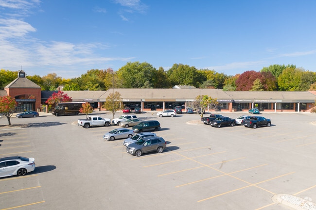
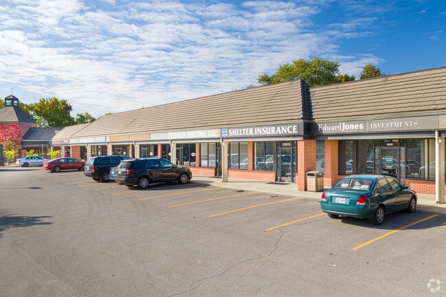
Property Record
12902 State Line Rd, Leawood, KS 66209

Current Lease Availabilities
Property Detail
12902 State Line Rd
HP72000000-000H
LEAWOOD SOUTH (SECOND PLAT)PT TR H BG SE CR TR W 462.67 N 46.50 E 56.17 N 156.16 NW 51.66 NE 70 NW 115 SW 40 NW 41.40 NE 99.40 SE 58 NE 83.02 SE 68.02 NE 180 SE 38 NE 115 NW 27 NE 57.74 S623.38 TO POB EX BG 536.38 N SE CR W 38.5 SW 163.08 SE 200 NE 7
Regionalshoppingcenterormallwithanchorstore
Johnson
SD-CR
Kansas
B and X Area of moderate flood hazard, usually the area between the limits of the 100-year and 500-year floods.
4.25 AC
2025
South Johnson County
2025
Kansas City
053302
Kansas City, MO-KS
34,772 SF
NEARBY LISTINGS FOR SALE OR LEASE
DEMOGRAPHICS near 12902 State Line Rd
1 mile
3 mile
5 mile
2025 Total Population
6,525
48,841
159,001
2030 Population
6,633
49,955
163,268
Pop Growth 2025-2030
+ 1.66%
+ 2.28%
+ 2.68%
Average Age
46
45
42
2025 Total Households
2,648
20,260
66,520
HH Growth 2025-2030
+ 1.77%
+ 2.29%
+ 2.73%
Median Household Inc
$122,078
$124,769
$101,725
Avg Household Size
2.40
2.30
2.30
2025 Avg HH Vehicles
2.00
2.00
2.00
Median Home Value
$483,222
$540,308
$439,474
Median Year Built
1985
1990
1988
Nearby Places
Map Layers
Map Styles
 Street
 Aerial
Layers
 Traffic
 Biking
Places
Listings with unknown addresses are not visible on the map
- Restaurants
- Banks
- Shops
- Fitness
- Groceries
PUBLIC TRANSPORTATION
AIRPORT
Kansas City International
Drive
Walk
Distance
Kansas City International
52 min
41.0 mi
Freight Ports
Tulsa Port Of Catoosa
Drive
Walk
Distance
Tulsa Port Of Catoosa
249 min
223.3 mi
Nearby Properties
Address
Land Use
TOTAL SIZE
Lot Size
Zoning
Address
Land Use
TOTAL SIZE
Lot Size
Zoning
47.39 AC
AG
Address
Land Use
TOTAL SIZE
Lot Size
Zoning
364,818 SF
25.48 AC
R-1
Address
Land Use
TOTAL SIZE
Lot Size
Zoning
384,819 SF
67.59 AC
AG
Address
Land Use
TOTAL SIZE
Lot Size
Zoning
316,432 SF
29.39 AC
R-1
Address
Land Use
TOTAL SIZE
Lot Size
Zoning
305,147 SF
49.02 AC
R-1
Address
Land Use
TOTAL SIZE
Lot Size
Zoning
184,524 SF
33.20 AC
AG
Address
Land Use
TOTAL SIZE
Lot Size
Zoning
361,242 SF
25.13 AC
R-1
Address
Land Use
TOTAL SIZE
Lot Size
Zoning
173,314 SF
25.83 AC
R-1
Address
Land Use
TOTAL SIZE
Lot Size
Zoning
325,588 SF
36.63 AC
SD-CR
Address
Land Use
TOTAL SIZE
Lot Size
Zoning
79,917 SF
7.86 AC
SD-NCR
Address
Land Use
TOTAL SIZE
Lot Size
Zoning
102,411 SF
17.02 AC
AG
Address
Land Use
TOTAL SIZE
Lot Size
Zoning
59,570 SF
8.46 AC
SD-O
Address
Land Use
TOTAL SIZE
Lot Size
Zoning
105,110 SF
12.38 AC
AG
Address
Land Use
TOTAL SIZE
Lot Size
Zoning
166,097 SF
37.29 AC
R-1
Address
Land Use
TOTAL SIZE
Lot Size
Zoning
72,184 SF
9.53 AC
AG
Address
Land Use
TOTAL SIZE
Lot Size
Zoning
159,274 SF
14.38 AC
SD-CR
Address
Land Use
TOTAL SIZE
Lot Size
Zoning
157,280 SF
25.10 AC
Address
Land Use
TOTAL SIZE
Lot Size
Zoning
45,775 SF
17.05 AC
BP
Address
Land Use
TOTAL SIZE
Lot Size
Zoning
66,083 SF
14.91 AC
R-1
Address
Land Use
TOTAL SIZE
Lot Size
Zoning
40,181 SF
1.80 AC
MXD
Address
Land Use
TOTAL SIZE
Lot Size
Zoning
28,633 SF
13.25 AC
R-1
Address
Land Use
TOTAL SIZE
Lot Size
Zoning
68,493 SF
9.92 AC
R-1
Address
Land Use
TOTAL SIZE
Lot Size
Zoning
36,012 SF
18.12 AC
AG
Address
Land Use
TOTAL SIZE
Lot Size
Zoning
9,508 SF
8.29 AC
RP-1
Address
Land Use
TOTAL SIZE
Lot Size
Zoning
43,021 SF
7.47 AC
SD-O
Address
Land Use
TOTAL SIZE
Lot Size
Zoning
92,726 SF
6.83 AC
CP-2
Address
Land Use
TOTAL SIZE
Lot Size
Zoning
60,960 SF
4.82 AC
SD-NCR
Address
Land Use
TOTAL SIZE
Lot Size
Zoning
50,177 SF
5.54 AC
CP-2
Address
Land Use
TOTAL SIZE
Lot Size
Zoning
64,785 SF
24.54 AC
RP-4 (CURR
Address
Land Use
TOTAL SIZE
Lot Size
Zoning
41,203 SF
8.03 AC
MXD
The World's #1 Commercial Real Estate Marketplace
Connect with us
© 2026 CoStar Group
The information above has been obtained from sources believed reliable. While we do not doubt its accuracy we have not verified it and make no guarantee, warranty or representation about it. It is your responsibility to independently confirm its accuracy and completeness. Any projections, opinions, assumptions, or estimates used are for example only and do not represent the current or future performance of the property. The value of this transaction to you depends on tax and other factors which should be evaluated by your tax, financial, and legal advisors. You and your advisors should conduct a careful, independent investigation of the property to determine to your satisfaction the suitability of the property for your needs.