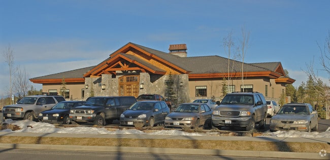
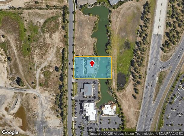
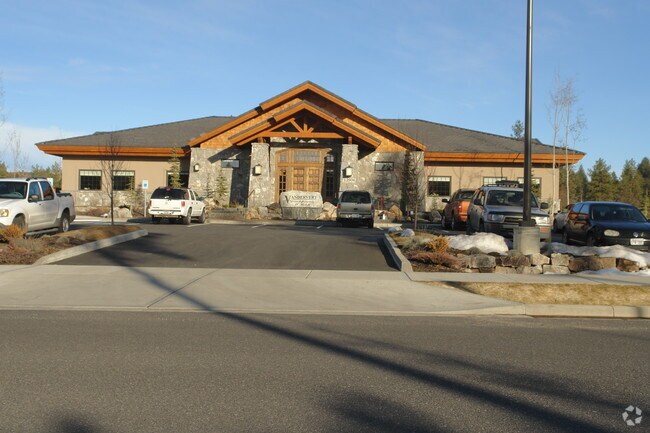
Property Record
12906 N Addison St, Spokane, WA 99218
NEARBY LISTINGS FOR SALE OR LEASE
Property Detail
12906 N Addison St
Spokane-Spokane Valley, WA
Binding Site Plan Bsp-101-05
36053.9071
BSP 2005-101 LT 5 (AFN 5407837)
Financialbuilding
Spokane
X
Washington
53063C0369D
5
2025
1.45 AC
2025
NW North Metro
010506
Spokane
5,937 SF
DEMOGRAPHICS near 12906 N Addison St
1 Mile
3 Mile
5 Mile
2024 Total Population
8,193
40,132
104,605
2029 Population
8,651
42,513
110,920
Pop Growth 2024-2029
+ 5.59%
+ 5.93%
+ 6.04%
Average Age
43
39
40
2024 Total Households
3,110
14,746
40,217
HH Growth 2024-2029
+ 5.63%
+ 6.12%
+ 6.21%
Median Household Inc
$79,458
$74,326
$69,841
Avg Household Size
2.50
2.60
2.50
2024 Avg HH Vehicles
2.00
2.00
2.00
Median Home Value
$426,755
$390,624
$366,072
Median Year Built
1993
1989
1983
Nearby Places
Map Layers
Map Styles
 Street
 Aerial
- Restaurants
- Banks
- Shops
- Fitness
- Groceries
PUBLIC TRANSPORTATION
COMMUTER RAIL
DRIVE
WALK
Distance
20 min
8.5 mi
AIRPORT
Spokane International
DRIVE
WALK
Distance
Spokane International
30 min
14.9 mi
Nearby Properties
Address
Land Use
TOTAL SIZE
Lot Size
Zoning
Address
Land Use
TOTAL SIZE
Lot Size
Zoning
545,909 SF
92.96 AC
LDR
Address
Land Use
TOTAL SIZE
Lot Size
Zoning
278,777 SF
5.47 AC
HDR
Address
Land Use
TOTAL SIZE
Lot Size
Zoning
456,984 SF
26.06 AC
O
Address
Land Use
TOTAL SIZE
Lot Size
Zoning
317,750 SF
31.10 AC
GC
Address
Land Use
TOTAL SIZE
Lot Size
Zoning
78,497 SF
9.19 AC
MU
Address
Land Use
TOTAL SIZE
Lot Size
Zoning
215,573 SF
11.30 AC
HDR
Address
Land Use
TOTAL SIZE
Lot Size
Zoning
172,525 SF
8.18 AC
HDR
Address
Land Use
TOTAL SIZE
Lot Size
Zoning
116,772 SF
8.56 AC
MU
Address
Land Use
TOTAL SIZE
Lot Size
Zoning
166,390 SF
19.33 AC
MU
Address
Land Use
TOTAL SIZE
Lot Size
Zoning
131,469 SF
7.24 AC
RMF
Address
Land Use
TOTAL SIZE
Lot Size
Zoning
150,061 SF
5.01 AC
GC
Address
Land Use
TOTAL SIZE
Lot Size
Zoning
67,094 SF
9.33 AC
RSF
Address
Land Use
TOTAL SIZE
Lot Size
Zoning
209,047 SF
41.68 AC
HI
Address
Land Use
TOTAL SIZE
Lot Size
Zoning
121,519 SF
6.26 AC
HDR
Address
Land Use
TOTAL SIZE
Lot Size
Zoning
64,558 SF
11.91 AC
LDR
Address
Land Use
TOTAL SIZE
Lot Size
Zoning
183,152 SF
38.47 AC
LDR
Address
Land Use
TOTAL SIZE
Lot Size
Zoning
230,295 SF
22.41 AC
GC
Address
Land Use
TOTAL SIZE
Lot Size
Zoning
35,343 SF
5.31 AC
GC
Address
Land Use
TOTAL SIZE
Lot Size
Zoning
183,704 SF
12.67 AC
RMF
Address
Land Use
TOTAL SIZE
Lot Size
Zoning
179,208 SF
13.94 AC
RMF
Address
Land Use
TOTAL SIZE
Lot Size
Zoning
317,432 SF
36.25 AC
LDR
Address
Land Use
TOTAL SIZE
Lot Size
Zoning
156,212 SF
11.31 AC
MU
Address
Land Use
TOTAL SIZE
Lot Size
Zoning
107,246 SF
6.63 AC
GC
Address
Land Use
TOTAL SIZE
Lot Size
Zoning
165,954 SF
15.18 AC
RC
Address
Land Use
TOTAL SIZE
Lot Size
Zoning
105,791 SF
22.82 AC
LDR
Address
Land Use
TOTAL SIZE
Lot Size
Zoning
79,576 SF
12.71 AC
GC
Address
Land Use
TOTAL SIZE
Lot Size
Zoning
71,200 SF
7.15 AC
RMF
Address
Land Use
TOTAL SIZE
Lot Size
Zoning
57,420 SF
4.28 AC
GC
Address
Land Use
TOTAL SIZE
Lot Size
Zoning
98,738 SF
6.14 AC
O
Address
Land Use
TOTAL SIZE
Lot Size
Zoning
68,670 SF
19.71 AC
UR
The World's #1 Commercial Real Estate Marketplace
Connect with us
© 2026 CoStar Group
The information above has been obtained from sources believed reliable. While we do not doubt its accuracy we have not verified it and make no guarantee, warranty or representation about it. It is your responsibility to independently confirm its accuracy and completeness. Any projections, opinions, assumptions, or estimates used are for example only and do not represent the current or future performance of the property. The value of this transaction to you depends on tax and other factors which should be evaluated by your tax, financial, and legal advisors. You and your advisors should conduct a careful, independent investigation of the property to determine to your satisfaction the suitability of the property for your needs.