Property Record
N Highway 67, Midlothian, TX 76065

NEARBY LISTINGS FOR SALE OR LEASE
Property Detail
N Highway 67
Dallas-Fort Worth-Arlington, TX
J W Payne
231044
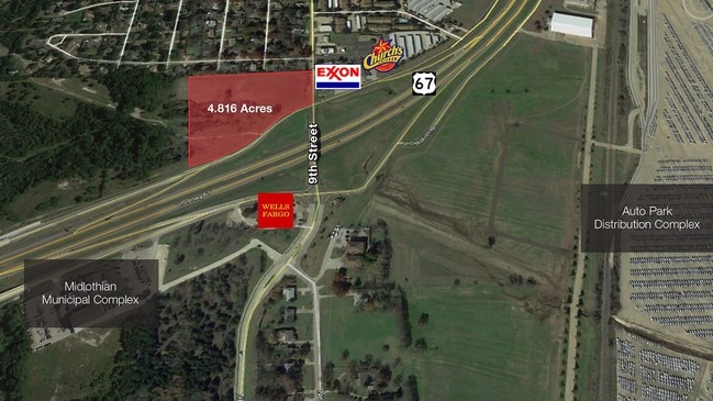
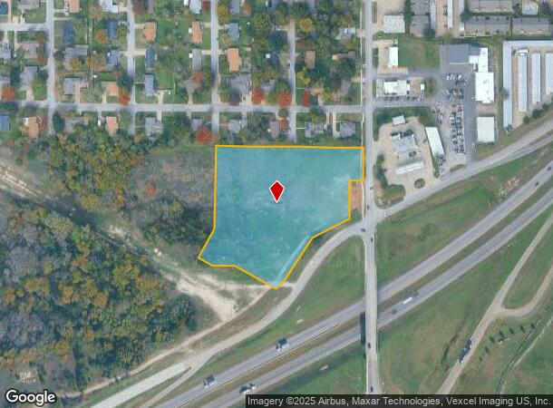
883 J M PAYNE 4.816 ACRES
Commercialacreage
Ellis
X
Texas
48139C0155G
4.82 AC
2024
Ellis County
2025
Dallas/Ft Worth
060702
DEMOGRAPHICS near N Highway 67
1 Mile
3 Mile
5 Mile
2024 Total Population
4,379
20,304
42,002
2029 Population
5,630
25,764
52,709
Pop Growth 2024-2029
+ 28.57%
+ 26.89%
+ 25.49%
Average Age
37
37
38
2024 Total Households
1,580
7,016
14,100
HH Growth 2024-2029
+ 28.73%
+ 27.24%
+ 25.83%
Median Household Inc
$91,439
$99,518
$113,141
Avg Household Size
2.80
2.90
3.00
2024 Avg HH Vehicles
2.00
2.00
2.00
Median Home Value
$286,874
$289,349
$330,069
Median Year Built
2004
2005
2006
Nearby Places
Map Layers
Map Styles
 Street
 Aerial
- Restaurants
- Banks
- Shops
- Fitness
- Groceries
PUBLIC TRANSPORTATION
AIRPORT
Dallas Love Field
DRIVE
WALK
Distance
Dallas Love Field
40 min
30.8 mi
Dallas-Fort Worth International
DRIVE
WALK
Distance
Dallas-Fort Worth International
44 min
34.7 mi
SALE & LEASE HISTORY
LISTING DATE
SALE/LEASE

Sep 24, 2016
For Sale
Dec 14, 2018
For Sale
Nearby Properties
Address
Land Use
TOTAL SIZE
Lot Size
Zoning
Address
Land Use
TOTAL SIZE
Lot Size
Zoning
Address
Land Use
TOTAL SIZE
Lot Size
Zoning
176,817 SF
30.71 AC
Address
Land Use
TOTAL SIZE
Lot Size
Zoning
471,921 SF
46 AC
Address
Land Use
TOTAL SIZE
Lot Size
Zoning
740,870 SF
73.29 AC
Address
Land Use
TOTAL SIZE
Lot Size
Zoning
305,283 SF
14.75 AC
Address
Land Use
TOTAL SIZE
Lot Size
Zoning
Address
Land Use
TOTAL SIZE
Lot Size
Zoning
347,406 SF
20.99 AC
Address
Land Use
TOTAL SIZE
Lot Size
Zoning
108,054 SF
26.99 AC
Address
Land Use
TOTAL SIZE
Lot Size
Zoning
730,356 SF
44.50 AC
Address
Land Use
TOTAL SIZE
Lot Size
Zoning
222,600 SF
9.31 AC
Address
Land Use
TOTAL SIZE
Lot Size
Zoning
179,177 SF
9.98 AC
Address
Land Use
TOTAL SIZE
Lot Size
Zoning
28,974 SF
47.07 AC
Address
Land Use
TOTAL SIZE
Lot Size
Zoning
98,001 SF
14.51 AC
Address
Land Use
TOTAL SIZE
Lot Size
Zoning
199,000 SF
7.76 AC
Address
Land Use
TOTAL SIZE
Lot Size
Zoning
99,264 SF
10 AC
Address
Land Use
TOTAL SIZE
Lot Size
Zoning
90,377 SF
27.54 AC
Address
Land Use
TOTAL SIZE
Lot Size
Zoning
117,457 SF
11.24 AC
Address
Land Use
TOTAL SIZE
Lot Size
Zoning
306,925 SF
19.44 AC
Address
Land Use
TOTAL SIZE
Lot Size
Zoning
203,850 SF
15.84 AC
Address
Land Use
TOTAL SIZE
Lot Size
Zoning
54,224 SF
1.72 AC
Address
Land Use
TOTAL SIZE
Lot Size
Zoning
183,300 SF
12.96 AC
Address
Land Use
TOTAL SIZE
Lot Size
Zoning
73,480 SF
295.63 AC
Address
Land Use
TOTAL SIZE
Lot Size
Zoning
1,864.30 AC
Address
Land Use
TOTAL SIZE
Lot Size
Zoning
160,775 SF
14.41 AC
Address
Land Use
TOTAL SIZE
Lot Size
Zoning
204,543 SF
5.11 AC
Address
Land Use
TOTAL SIZE
Lot Size
Zoning
224,941 SF
27.71 AC
Address
Land Use
TOTAL SIZE
Lot Size
Zoning
118,641 SF
12.07 AC
Address
Land Use
TOTAL SIZE
Lot Size
Zoning
56,641 SF
4.77 AC
Address
Land Use
TOTAL SIZE
Lot Size
Zoning
52,386 SF
3.94 AC
Address
Land Use
TOTAL SIZE
Lot Size
Zoning
190,120 SF
21.77 AC
The World's #1 Commercial Real Estate Marketplace
Connect with us
© 2025 CoStar Group
The information above has been obtained from sources believed reliable. While we do not doubt its accuracy we have not verified it and make no guarantee, warranty or representation about it. It is your responsibility to independently confirm its accuracy and completeness. Any projections, opinions, assumptions, or estimates used are for example only and do not represent the current or future performance of the property. The value of this transaction to you depends on tax and other factors which should be evaluated by your tax, financial, and legal advisors. You and your advisors should conduct a careful, independent investigation of the property to determine to your satisfaction the suitability of the property for your needs.