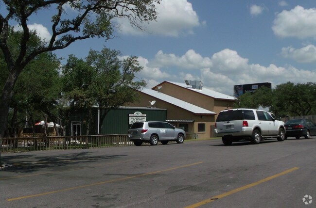
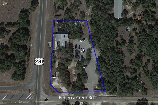
Property Record
12910 Us Highway 281 N, Spring Branch, TX 78070

Property Detail
12910 Us Highway 281 N
San Antonio-New Braunfels, TX
LOST MEADOWS, LOT 17 LG PT
32-0485-0017-00
Comal
Commercialnec
Texas
B and X Area of moderate flood hazard, usually the area between the limits of the 100-year and 500-year floods.
17
2024
2.07 AC
2025
Comal County
310610
San Antonio
5,109 SF
NEARBY LISTINGS FOR SALE OR LEASE
-
-
View all Spring Branch listings for sale on LoopNet.com
DEMOGRAPHICS near 12910 Us Highway 281 N
1 mile
3 mile
5 mile
2025 Total Population
1,510
7,156
12,217
2030 Population
1,782
8,406
14,330
Pop Growth 2025-2030
+ 18.01%
+ 17.47%
+ 17.30%
Average Age
39
42
43
2025 Total Households
532
2,674
4,609
HH Growth 2025-2030
+ 18.05%
+ 17.54%
+ 17.40%
Median Household Inc
$73,332
$82,514
$98,463
Avg Household Size
2.60
2.50
2.50
2025 Avg HH Vehicles
2.00
2.00
2.00
Median Home Value
$190,704
$361,596
$418,182
Median Year Built
1998
2005
2005
Nearby Places
Map Layers
Map Styles
 Street
 Aerial
Layers
 Traffic
 Biking
Places
Listings with unknown addresses are not visible on the map
- Restaurants
- Banks
- Shops
- Fitness
- Groceries
PUBLIC TRANSPORTATION
AIRPORT
San Antonio International
Drive
Walk
Distance
San Antonio International
36 min
29.0 mi
SALE & LEASE HISTORY
LISTING DATE
SALE/LEASE

Sep 23, 2016
For Sale
Jun 30, 2021
For Sale
Jul 08, 2021
For Sale
Nearby Properties
Address
Land Use
TOTAL SIZE
Lot Size
Zoning
Address
Land Use
TOTAL SIZE
Lot Size
Zoning
17,400 SF
3.76 AC
Address
Land Use
TOTAL SIZE
Lot Size
Zoning
8,896 SF
3.19 AC
Address
Land Use
TOTAL SIZE
Lot Size
Zoning
1,728 SF
4.14 AC
Address
Land Use
TOTAL SIZE
Lot Size
Zoning
16,264 SF
21.01 AC
Address
Land Use
TOTAL SIZE
Lot Size
Zoning
13,162 SF
25.99 AC
Address
Land Use
TOTAL SIZE
Lot Size
Zoning
12,968 SF
15.54 AC
Address
Land Use
TOTAL SIZE
Lot Size
Zoning
95.22 AC
Address
Land Use
TOTAL SIZE
Lot Size
Zoning
5,288 SF
133.02 AC
Address
Land Use
TOTAL SIZE
Lot Size
Zoning
26,658 SF
31.10 AC
Address
Land Use
TOTAL SIZE
Lot Size
Zoning
3,584 SF
10.54 AC
Address
Land Use
TOTAL SIZE
Lot Size
Zoning
10,000 SF
2.01 AC
Address
Land Use
TOTAL SIZE
Lot Size
Zoning
2,160 SF
13.79 AC
Address
Land Use
TOTAL SIZE
Lot Size
Zoning
2,240 SF
16.82 AC
Address
Land Use
TOTAL SIZE
Lot Size
Zoning
8,357 SF
15.47 AC
Address
Land Use
TOTAL SIZE
Lot Size
Zoning
2,800 SF
25.73 AC
Address
Land Use
TOTAL SIZE
Lot Size
Zoning
Address
Land Use
TOTAL SIZE
Lot Size
Zoning
4,736 SF
58.42 AC
Address
Land Use
TOTAL SIZE
Lot Size
Zoning
9,036 SF
0.98 AC
Address
Land Use
TOTAL SIZE
Lot Size
Zoning
9,416 SF
3.47 AC
Address
Land Use
TOTAL SIZE
Lot Size
Zoning
9,760 SF
2.85 AC
Address
Land Use
TOTAL SIZE
Lot Size
Zoning
Address
Land Use
TOTAL SIZE
Lot Size
Zoning
465 SF
16.03 AC
Address
Land Use
TOTAL SIZE
Lot Size
Zoning
5,450 SF
17.74 AC
Address
Land Use
TOTAL SIZE
Lot Size
Zoning
2,276 SF
2.75 AC
Address
Land Use
TOTAL SIZE
Lot Size
Zoning
4,400 SF
2 AC
Address
Land Use
TOTAL SIZE
Lot Size
Zoning
4,028 SF
2 AC
Address
Land Use
TOTAL SIZE
Lot Size
Zoning
1,268 SF
3.91 AC
Address
Land Use
TOTAL SIZE
Lot Size
Zoning
3,396 SF
37.34 AC
Address
Land Use
TOTAL SIZE
Lot Size
Zoning
The World's #1 Commercial Real Estate Marketplace
Connect with us
© 2026 CoStar Group
The information above has been obtained from sources believed reliable. While we do not doubt its accuracy we have not verified it and make no guarantee, warranty or representation about it. It is your responsibility to independently confirm its accuracy and completeness. Any projections, opinions, assumptions, or estimates used are for example only and do not represent the current or future performance of the property. The value of this transaction to you depends on tax and other factors which should be evaluated by your tax, financial, and legal advisors. You and your advisors should conduct a careful, independent investigation of the property to determine to your satisfaction the suitability of the property for your needs.