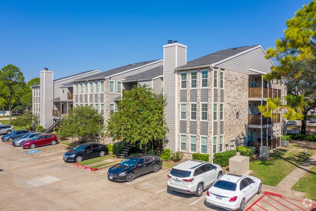
Property Record
12919 Whittington Dr, Houston, TX 77077

Property Detail
12919 Whittington Dr
1150850000003
RES B1 & C TR 2G ABST 24 W HARDIN ASHFORD CROSSING SEC 1
Apartment
HARRIS
B and X Area of moderate flood hazard, usually the area between the limits of the 100-year and 500-year floods.
Texas
2024
23.38 AC
2025
Briar Village
451406
Houston
638,248 SF
Houston-Pasadena-The Woodlands, TX
NEARBY LISTINGS FOR SALE OR LEASE
DEMOGRAPHICS near 12919 Whittington Dr
1 mile
3 mile
5 mile
2025 Total Population
31,006
170,863
388,990
2030 Population
33,077
182,209
414,857
Pop Growth 2025-2030
+ 6.68%
+ 6.64%
+ 6.65%
Average Age
37
38
38
2025 Total Households
14,618
71,271
150,357
HH Growth 2025-2030
+ 6.85%
+ 6.82%
+ 6.87%
Median Household Inc
$60,542
$69,883
$65,501
Avg Household Size
2.10
2.30
2.50
2025 Avg HH Vehicles
1.00
2.00
2.00
Median Home Value
$357,747
$364,950
$309,117
Median Year Built
1989
1987
1985
Nearby Places
Map Layers
Map Styles
 Street
 Aerial
Layers
 Traffic
 Biking
Places
Listings with unknown addresses are not visible on the map
- Restaurants
- Banks
- Shops
- Fitness
- Groceries
PUBLIC TRANSPORTATION
AIRPORT
William P Hobby
Drive
Walk
Distance
William P Hobby
46 min
28.7 mi
George Bush Intcntl/Houston
Drive
Walk
Distance
George Bush Intcntl/Houston
43 min
32.6 mi
Freight Ports
Port of Houston
Drive
Walk
Distance
Port of Houston
42 min
28.1 mi
Nearby Properties
Address
Land Use
TOTAL SIZE
Lot Size
Zoning
Address
Land Use
TOTAL SIZE
Lot Size
Zoning
2,976,779 SF
41.36 AC
Address
Land Use
TOTAL SIZE
Lot Size
Zoning
1,385,616 SF
6.48 AC
Address
Land Use
TOTAL SIZE
Lot Size
Zoning
1,131,022 SF
6.26 AC
Address
Land Use
TOTAL SIZE
Lot Size
Zoning
1,208,144 SF
6.15 AC
Address
Land Use
TOTAL SIZE
Lot Size
Zoning
759,908 SF
4.54 AC
Address
Land Use
TOTAL SIZE
Lot Size
Zoning
953,143 SF
63.82 AC
Address
Land Use
TOTAL SIZE
Lot Size
Zoning
1,543,856 SF
10.03 AC
Address
Land Use
TOTAL SIZE
Lot Size
Zoning
1,376,776 SF
113.43 AC
Address
Land Use
TOTAL SIZE
Lot Size
Zoning
764,429 SF
6.78 AC
Address
Land Use
TOTAL SIZE
Lot Size
Zoning
1,045,896 SF
11.14 AC
Address
Land Use
TOTAL SIZE
Lot Size
Zoning
430,096 SF
18.99 AC
Address
Land Use
TOTAL SIZE
Lot Size
Zoning
690,519 SF
26.57 AC
Address
Land Use
TOTAL SIZE
Lot Size
Zoning
617,832 SF
9.24 AC
Address
Land Use
TOTAL SIZE
Lot Size
Zoning
422,801 SF
12.71 AC
Address
Land Use
TOTAL SIZE
Lot Size
Zoning
520,277 SF
10.04 AC
Address
Land Use
TOTAL SIZE
Lot Size
Zoning
601,167 SF
14.93 AC
Address
Land Use
TOTAL SIZE
Lot Size
Zoning
845,902 SF
16.27 AC
Address
Land Use
TOTAL SIZE
Lot Size
Zoning
672,183 SF
8.80 AC
Address
Land Use
TOTAL SIZE
Lot Size
Zoning
803,103 SF
5.78 AC
Address
Land Use
TOTAL SIZE
Lot Size
Zoning
910,592 SF
6.35 AC
Address
Land Use
TOTAL SIZE
Lot Size
Zoning
775,560 SF
7.96 AC
Address
Land Use
TOTAL SIZE
Lot Size
Zoning
526,410 SF
20.43 AC
Address
Land Use
TOTAL SIZE
Lot Size
Zoning
487,054 SF
13.85 AC
Address
Land Use
TOTAL SIZE
Lot Size
Zoning
845,371 SF
32.37 AC
Address
Land Use
TOTAL SIZE
Lot Size
Zoning
403,650 SF
20.19 AC
Address
Land Use
TOTAL SIZE
Lot Size
Zoning
367,309 SF
14.72 AC
Address
Land Use
TOTAL SIZE
Lot Size
Zoning
709,724 SF
6.17 AC
Address
Land Use
TOTAL SIZE
Lot Size
Zoning
488,573 SF
20.57 AC
Address
Land Use
TOTAL SIZE
Lot Size
Zoning
499,216 SF
6.30 AC
The World's #1 Commercial Real Estate Marketplace
Connect with us
© 2026 CoStar Group
The information above has been obtained from sources believed reliable. While we do not doubt its accuracy we have not verified it and make no guarantee, warranty or representation about it. It is your responsibility to independently confirm its accuracy and completeness. Any projections, opinions, assumptions, or estimates used are for example only and do not represent the current or future performance of the property. The value of this transaction to you depends on tax and other factors which should be evaluated by your tax, financial, and legal advisors. You and your advisors should conduct a careful, independent investigation of the property to determine to your satisfaction the suitability of the property for your needs.