Property Record
1292 Hooksett Rd, Hooksett, NH 03106
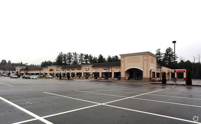

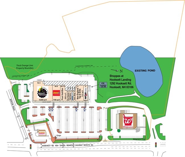

This Property Is For Sale
Property Detail
1292 Hooksett Rd
Departmentstore
Merrimack
PZ
New Hampshire
AE The base floodplain where base flood elevations are provided. AE Zones are now used on new format FIRMs instead of A1-A30 Zones.
21.52 AC
2024
Manchester/New Hampshire South Area
2024
Other Market Areas
003001
Concord, NH
48,550 SF
HOOK-000025-000000-000070
NEARBY LISTINGS FOR SALE OR LEASE
DEMOGRAPHICS near 1292 Hooksett Rd
1 mile
3 mile
5 mile
2024 Total Population
2,757
26,736
96,252
2029 Population
2,828
27,349
97,151
Pop Growth 2024-2029
+ 2.58%
+ 2.29%
+ 0.93%
Average Age
42
42
40
2024 Total Households
985
11,075
40,571
HH Growth 2024-2029
+ 2.74%
+ 2.45%
+ 1.03%
Median Household Inc
$92,148
$106,956
$87,130
Avg Household Size
2.60
2.30
2.20
2024 Avg HH Vehicles
2.00
2.00
2.00
Median Home Value
$480,746
$429,211
$391,309
Median Year Built
1989
1985
1972
Nearby Places
Map Layers
Map Styles
 Street
 Aerial
Transit
 Traffic
 Biking
Places
Listings with unknown addresses are not visible on the map
- Restaurants
- Banks
- Shops
- Fitness
- Groceries
PUBLIC TRANSPORTATION
AIRPORT
Manchester Boston Regional
Drive
Walk
Distance
Manchester Boston Regional
26 min
12.6 mi
Portsmouth International at Pease
Drive
Walk
Distance
Portsmouth International at Pease
63 min
41.5 mi
Freight Ports
Port of Boston
Drive
Walk
Distance
Port of Boston
88 min
56.8 mi
Nearby Properties
Address
Land Use
TOTAL SIZE
Lot Size
Zoning
Address
Land Use
TOTAL SIZE
Lot Size
Zoning
58,227 SF
66.52 AC
Address
Land Use
TOTAL SIZE
Lot Size
Zoning
26,232 SF
39.97 AC
Address
Land Use
TOTAL SIZE
Lot Size
Zoning
12.60 AC
PZ
Address
Land Use
TOTAL SIZE
Lot Size
Zoning
135,686 SF
30.23 AC
Address
Land Use
TOTAL SIZE
Lot Size
Zoning
36,070 SF
141.66 AC
MUD4
Address
Land Use
TOTAL SIZE
Lot Size
Zoning
26,125 SF
150.66 AC
Address
Land Use
TOTAL SIZE
Lot Size
Zoning
51.32 AC
MUD4
Address
Land Use
TOTAL SIZE
Lot Size
Zoning
211,525 SF
93.01 AC
Address
Land Use
TOTAL SIZE
Lot Size
Zoning
154,363 SF
17.25 AC
MUD3
Address
Land Use
TOTAL SIZE
Lot Size
Zoning
23,236 SF
26.66 AC
MUD2
Address
Land Use
TOTAL SIZE
Lot Size
Zoning
4,400 SF
76.15 AC
MUD4
Address
Land Use
TOTAL SIZE
Lot Size
Zoning
1,998 SF
72.09 AC
MDR
Address
Land Use
TOTAL SIZE
Lot Size
Zoning
44,301 SF
71.24 AC
Address
Land Use
TOTAL SIZE
Lot Size
Zoning
Address
Land Use
TOTAL SIZE
Lot Size
Zoning
82,670 SF
27.76 AC
PZ
Address
Land Use
TOTAL SIZE
Lot Size
Zoning
5,150 SF
13.50 AC
Address
Land Use
TOTAL SIZE
Lot Size
Zoning
1,621 SF
8.24 AC
Address
Land Use
TOTAL SIZE
Lot Size
Zoning
69,339 SF
39.63 AC
IND
Address
Land Use
TOTAL SIZE
Lot Size
Zoning
96,192 SF
17.42 AC
IND
Address
Land Use
TOTAL SIZE
Lot Size
Zoning
42,008 SF
4.33 AC
Address
Land Use
TOTAL SIZE
Lot Size
Zoning
42,692 SF
3.98 AC
Address
Land Use
TOTAL SIZE
Lot Size
Zoning
95,626 SF
19.51 AC
MUD3
Address
Land Use
TOTAL SIZE
Lot Size
Zoning
41,252 SF
4.74 AC
Address
Land Use
TOTAL SIZE
Lot Size
Zoning
85,656 SF
13.56 AC
MUD3
Address
Land Use
TOTAL SIZE
Lot Size
Zoning
153,663 SF
25.16 AC
MUD3
Address
Land Use
TOTAL SIZE
Lot Size
Zoning
3,608 SF
133.83 AC
Address
Land Use
TOTAL SIZE
Lot Size
Zoning
73,460 SF
3.56 AC
Address
Land Use
TOTAL SIZE
Lot Size
Zoning
119,910 SF
15.07 AC
MUD3
Address
Land Use
TOTAL SIZE
Lot Size
Zoning
41,252 SF
4.87 AC
Address
Land Use
TOTAL SIZE
Lot Size
Zoning
42,008 SF
3.74 AC
The World's #1 Commercial Real Estate Marketplace
Connect with us
© 2026 CoStar Group
The information above has been obtained from sources believed reliable. While we do not doubt its accuracy we have not verified it and make no guarantee, warranty or representation about it. It is your responsibility to independently confirm its accuracy and completeness. Any projections, opinions, assumptions, or estimates used are for example only and do not represent the current or future performance of the property. The value of this transaction to you depends on tax and other factors which should be evaluated by your tax, financial, and legal advisors. You and your advisors should conduct a careful, independent investigation of the property to determine to your satisfaction the suitability of the property for your needs.