Property Record
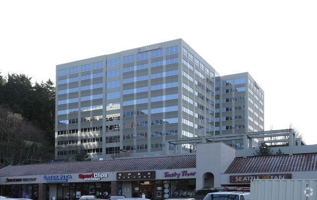
12920 Se 38Th St, Bellevue, WA 98006


NEARBY LISTINGS FOR SALE OR LEASE
Property Detail
12920 Se 38Th St
Seattle-Tacoma-Bellevue, WA
Newport Corporate Center Bsp
606763-0050
NEWPORT CORPORATE CENTER BSP
Officebuilding
King
X
Washington
53033C0658G
5
2025
5.18 AC
2024
I-90 Corridor
024800
Seattle/Puget Sound
555,862 SF
DEMOGRAPHICS near 12920 Se 38Th St
1 Mile
3 Mile
5 Mile
2024 Total Population
12,472
108,506
232,084
2029 Population
12,508
109,809
234,978
Pop Growth 2024-2029
+ 0.29%
+ 1.20%
+ 1.25%
Average Age
40
40
40
2024 Total Households
4,640
42,302
92,455
HH Growth 2024-2029
+ 0.09%
+ 1.25%
+ 1.34%
Median Household Inc
$146,330
$157,351
$156,173
Avg Household Size
2.60
2.50
2.40
2024 Avg HH Vehicles
2.00
2.00
2.00
Median Home Value
$1,046,476
$1,053,439
$1,055,918
Median Year Built
1974
1981
1983
Nearby Places
Map Layers
Map Styles
 Street
 Aerial
- Restaurants
- Banks
- Shops
- Fitness
- Groceries
PUBLIC TRANSPORTATION
COMMUTER RAIL
King Street (Seattle) Station (Sounder South Line - Central Puget Sound Regional Transit Authority Rail (Link Light Rail/Sounder))
DRIVE
WALK
Distance
King Street (Seattle) Station (Sounder South Line - Central Puget Sound Regional Transit Authority Rail (Link Light Rail/Sounder))
14 min
8.9 mi
AIRPORT
Seattle-Tacoma International
DRIVE
WALK
Distance
Seattle-Tacoma International
25 min
14.8 mi
Seattle Paine Field International
DRIVE
WALK
Distance
Seattle Paine Field International
40 min
26.5 mi
Freight Ports
Port of Seattle
DRIVE
WALK
Distance
Port of Seattle
20 min
11.7 mi
Nearby Properties
Address
Land Use
TOTAL SIZE
Lot Size
Zoning
Address
Land Use
TOTAL SIZE
Lot Size
Zoning
521,058 SF
2.46 AC
DT-O-2-S
Address
Land Use
TOTAL SIZE
Lot Size
Zoning
545,670 SF
44.48 AC
MF-3
Address
Land Use
TOTAL SIZE
Lot Size
Zoning
574,970 SF
1.72 AC
DNTNO-1
Address
Land Use
TOTAL SIZE
Lot Size
Zoning
781,977 SF
1.32 AC
DT-O-2-S
Address
Land Use
TOTAL SIZE
Lot Size
Zoning
723,028 SF
1.73 AC
DNTNO-1
Address
Land Use
TOTAL SIZE
Lot Size
Zoning
372,228 SF
1.04 AC
DT-O-2-S
Address
Land Use
TOTAL SIZE
Lot Size
Zoning
976,392 SF
0.88 AC
DNTNO-1
Address
Land Use
TOTAL SIZE
Lot Size
Zoning
265,300 SF
1.91 AC
DNTN-OB
Address
Land Use
TOTAL SIZE
Lot Size
Zoning
695,328 SF
4.81 AC
DT-O-2-E
Address
Land Use
TOTAL SIZE
Lot Size
Zoning
726,000 SF
1.66 AC
DNTNO-1
Address
Land Use
TOTAL SIZE
Lot Size
Zoning
408,400 SF
27.58 AC
R-20
Address
Land Use
TOTAL SIZE
Lot Size
Zoning
52,463 SF
79.31 AC
R-5
Address
Land Use
TOTAL SIZE
Lot Size
Zoning
2.25 AC
DNTNO-1
Address
Land Use
TOTAL SIZE
Lot Size
Zoning
337,096 SF
0.94 AC
DNTN-MU
Address
Land Use
TOTAL SIZE
Lot Size
Zoning
230,239 SF
1.77 AC
DNTN-MU
Address
Land Use
TOTAL SIZE
Lot Size
Zoning
629,094 SF
2.01 AC
DNTN-MU
Address
Land Use
TOTAL SIZE
Lot Size
Zoning
177,408 SF
2.65 AC
DNTN-OB
Address
Land Use
TOTAL SIZE
Lot Size
Zoning
300,236 SF
1.94 AC
DT-MU-CC
Address
Land Use
TOTAL SIZE
Lot Size
Zoning
493,400 SF
1.11 AC
DNTNO-1
Address
Land Use
TOTAL SIZE
Lot Size
Zoning
324,656 SF
15.40 AC
R-30
Address
Land Use
TOTAL SIZE
Lot Size
Zoning
102,562 SF
4.77 AC
DT-OLB-S
Address
Land Use
TOTAL SIZE
Lot Size
Zoning
193,180 SF
1.45 AC
DNTN-MU
Address
Land Use
TOTAL SIZE
Lot Size
Zoning
36,470 SF
38.01 AC
R-4
Address
Land Use
TOTAL SIZE
Lot Size
Zoning
206,112 SF
1.47 AC
DNTN-OB
Address
Land Use
TOTAL SIZE
Lot Size
Zoning
230,886 SF
4.58 AC
MU-R
Address
Land Use
TOTAL SIZE
Lot Size
Zoning
186,750 SF
2.06 AC
DNTN-MU
Address
Land Use
TOTAL SIZE
Lot Size
Zoning
231,745 SF
9.07 AC
OLB
Address
Land Use
TOTAL SIZE
Lot Size
Zoning
32,709 SF
0.82 AC
DNTN-MU
Address
Land Use
TOTAL SIZE
Lot Size
Zoning
458,250 SF
1.50 AC
DNTN-MU
Address
Land Use
TOTAL SIZE
Lot Size
Zoning
116,320 SF
0.58 AC
DNTN-OB
The World's #1 Commercial Real Estate Marketplace
Connect with us
© 2025 CoStar Group
The information above has been obtained from sources believed reliable. While we do not doubt its accuracy we have not verified it and make no guarantee, warranty or representation about it. It is your responsibility to independently confirm its accuracy and completeness. Any projections, opinions, assumptions, or estimates used are for example only and do not represent the current or future performance of the property. The value of this transaction to you depends on tax and other factors which should be evaluated by your tax, financial, and legal advisors. You and your advisors should conduct a careful, independent investigation of the property to determine to your satisfaction the suitability of the property for your needs.