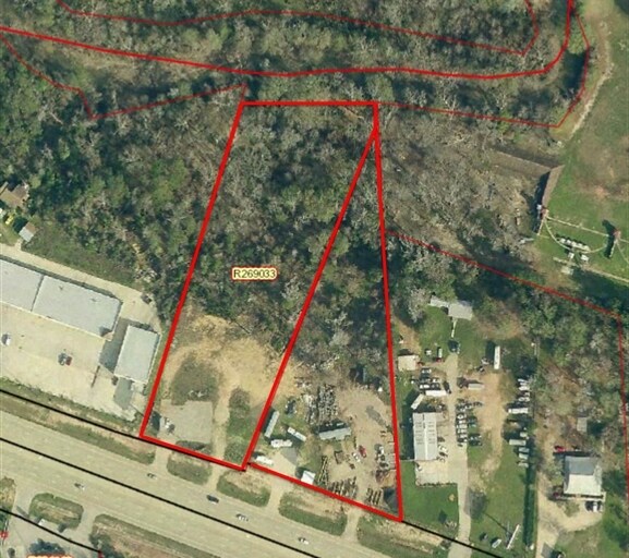
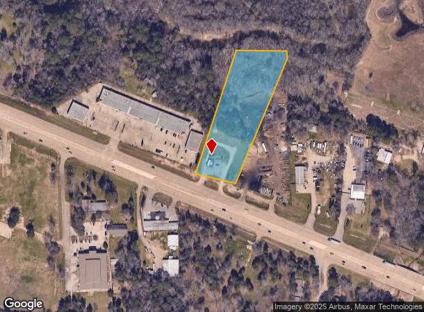
Property Record
12922 Highway 105 W, Conroe, TX 77304
NEARBY LISTINGS FOR SALE OR LEASE
Property Detail
12922 Highway 105 W
Houston-The Woodlands-Sugar Land, TX
Singleton J W
0496-00-02520
A0496 - SINGLETON J W, TRACT 25A-1, 25-B, ACRES 3.433
Commercialnec
Montgomery
AE
Texas
48339C0360G
3.43 AC
2024
Outlying Montgomery Cnty
2025
Houston
694307
DEMOGRAPHICS near 12922 Highway 105 W
1 Mile
3 Mile
5 Mile
2024 Total Population
1,893
18,842
73,879
2029 Population
2,348
23,516
91,783
Pop Growth 2024-2029
+ 24.04%
+ 24.81%
+ 24.23%
Average Age
39
41
41
2024 Total Households
733
7,393
28,986
HH Growth 2024-2029
+ 24.15%
+ 24.92%
+ 24.31%
Median Household Inc
$71,558
$83,728
$89,066
Avg Household Size
2.60
2.60
2.50
2024 Avg HH Vehicles
2.00
2.00
2.00
Median Home Value
$249,346
$300,437
$326,744
Median Year Built
2010
2010
2007
Nearby Places
Map Layers
Map Styles
 Street
 Aerial
- Restaurants
- Banks
- Shops
- Fitness
- Groceries
PUBLIC TRANSPORTATION
AIRPORT
George Bush Intcntl/Houston
DRIVE
WALK
Distance
George Bush Intcntl/Houston
47 min
37.3 mi
Freight Ports
Port of Houston
DRIVE
WALK
Distance
Port of Houston
70 min
53.0 mi
Nearby Properties
Address
Land Use
TOTAL SIZE
Lot Size
Zoning
Address
Land Use
TOTAL SIZE
Lot Size
Zoning
229,345 SF
12.36 AC
1
Address
Land Use
TOTAL SIZE
Lot Size
Zoning
134,621 SF
26.37 AC
Address
Land Use
TOTAL SIZE
Lot Size
Zoning
313,974 SF
25.03 AC
1
Address
Land Use
TOTAL SIZE
Lot Size
Zoning
287,364 SF
23.45 AC
4
Address
Land Use
TOTAL SIZE
Lot Size
Zoning
203,934 SF
11.75 AC
Address
Land Use
TOTAL SIZE
Lot Size
Zoning
382,810 SF
18.58 AC
1
Address
Land Use
TOTAL SIZE
Lot Size
Zoning
114,101 SF
43.80 AC
Address
Land Use
TOTAL SIZE
Lot Size
Zoning
402,840 SF
26.73 AC
Address
Land Use
TOTAL SIZE
Lot Size
Zoning
69,122 SF
5.57 AC
Address
Land Use
TOTAL SIZE
Lot Size
Zoning
170,050 SF
10.80 AC
Address
Land Use
TOTAL SIZE
Lot Size
Zoning
47,530 SF
8.03 AC
3
Address
Land Use
TOTAL SIZE
Lot Size
Zoning
68,576 SF
26.39 AC
Address
Land Use
TOTAL SIZE
Lot Size
Zoning
99,820 SF
4.51 AC
1
Address
Land Use
TOTAL SIZE
Lot Size
Zoning
74,395 SF
8.44 AC
Address
Land Use
TOTAL SIZE
Lot Size
Zoning
35,816 SF
251.16 AC
1
Address
Land Use
TOTAL SIZE
Lot Size
Zoning
26,278 SF
9.39 AC
Address
Land Use
TOTAL SIZE
Lot Size
Zoning
54,511 SF
14.42 AC
1
Address
Land Use
TOTAL SIZE
Lot Size
Zoning
14,628 SF
1.33 AC
Address
Land Use
TOTAL SIZE
Lot Size
Zoning
29,500 SF
1.59 AC
Address
Land Use
TOTAL SIZE
Lot Size
Zoning
18,630 SF
11.34 AC
1
Address
Land Use
TOTAL SIZE
Lot Size
Zoning
77,850 SF
6.11 AC
1
Address
Land Use
TOTAL SIZE
Lot Size
Zoning
39,210 SF
3.50 AC
Address
Land Use
TOTAL SIZE
Lot Size
Zoning
24,420 SF
2.13 AC
Address
Land Use
TOTAL SIZE
Lot Size
Zoning
50,008 SF
8.86 AC
1
Address
Land Use
TOTAL SIZE
Lot Size
Zoning
46,048 SF
11.63 AC
1
Address
Land Use
TOTAL SIZE
Lot Size
Zoning
125,615 SF
9.40 AC
Address
Land Use
TOTAL SIZE
Lot Size
Zoning
18,666 SF
10 AC
1
Address
Land Use
TOTAL SIZE
Lot Size
Zoning
14,638 SF
2.74 AC
1
Address
Land Use
TOTAL SIZE
Lot Size
Zoning
24,376 SF
1.53 AC
The World's #1 Commercial Real Estate Marketplace
Connect with us
© 2025 CoStar Group
The information above has been obtained from sources believed reliable. While we do not doubt its accuracy we have not verified it and make no guarantee, warranty or representation about it. It is your responsibility to independently confirm its accuracy and completeness. Any projections, opinions, assumptions, or estimates used are for example only and do not represent the current or future performance of the property. The value of this transaction to you depends on tax and other factors which should be evaluated by your tax, financial, and legal advisors. You and your advisors should conduct a careful, independent investigation of the property to determine to your satisfaction the suitability of the property for your needs.