Property Record
12925 N Oracle Rd, Tucson, AZ 85739
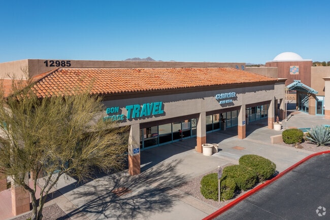

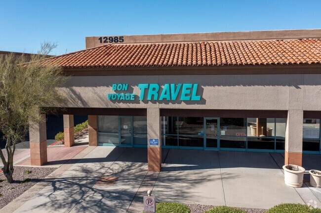
Property Detail
12925 N Oracle Rd
223-02-017R
PTN W722.64 N656.52 LYG N & ADJ RANCHO VISTOSO BLVD & W & ADJ TO TUCSON FLORENCE HWY 10.96 AC SEC 29-11-14
Storebuilding
Pima
B and X Area of moderate flood hazard, usually the area between the limits of the 100-year and 500-year floods.
Arizona
2025
10.96 AC
2026
North/Oro Valley
004643
Tucson
77,043 SF
Tucson, AZ
NEARBY LISTINGS FOR SALE OR LEASE
DEMOGRAPHICS near 12925 N Oracle Rd
1 mile
3 mile
5 mile
2025 Total Population
1,398
22,744
51,230
2030 Population
1,453
23,885
53,274
Pop Growth 2025-2030
+ 3.93%
+ 5.02%
+ 3.99%
Average Age
56
53
50
2025 Total Households
691
10,164
22,335
HH Growth 2025-2030
+ 4.20%
+ 5.19%
+ 4.17%
Median Household Inc
$103,125
$107,414
$109,684
Avg Household Size
2.00
2.20
2.20
2025 Avg HH Vehicles
2.00
2.00
2.00
Median Home Value
$399,999
$454,418
$459,617
Median Year Built
1997
1998
1997
Nearby Places
Map Layers
Map Styles
 Street
 Aerial
Layers
 Traffic
 Biking
Places
Listings with unknown addresses are not visible on the map
- Restaurants
- Banks
- Shops
- Fitness
- Groceries
PUBLIC TRANSPORTATION
AIRPORT
Tucson International
Drive
Walk
Distance
Tucson International
44 min
25.2 mi
Freight Ports
Port of San Diego
Drive
Walk
Distance
Port of San Diego
437 min
404.7 mi
SALE & LEASE HISTORY
LISTING DATE
SALE/LEASE

Sep 24, 2016
For Lease
Nearby Properties
Address
Land Use
TOTAL SIZE
Lot Size
Zoning
Address
Land Use
TOTAL SIZE
Lot Size
Zoning
368,956 SF
58.86 AC
CPI
Address
Land Use
TOTAL SIZE
Lot Size
Zoning
26,560 SF
9.02 AC
PAD
Address
Land Use
TOTAL SIZE
Lot Size
Zoning
231,366 SF
34.15 AC
PAD
Address
Land Use
TOTAL SIZE
Lot Size
Zoning
362,401 SF
19.55 AC
PAD
Address
Land Use
TOTAL SIZE
Lot Size
Zoning
551,678 SF
27.49 AC
PAD
Address
Land Use
TOTAL SIZE
Lot Size
Zoning
Address
Land Use
TOTAL SIZE
Lot Size
Zoning
320,757 SF
15.73 AC
Address
Land Use
TOTAL SIZE
Lot Size
Zoning
187,045 SF
16.70 AC
PAD
Address
Land Use
TOTAL SIZE
Lot Size
Zoning
214,008 SF
9.20 AC
Address
Land Use
TOTAL SIZE
Lot Size
Zoning
194,629 SF
17.47 AC
PAD
Address
Land Use
TOTAL SIZE
Lot Size
Zoning
206,109 SF
7.12 AC
PAD
Address
Land Use
TOTAL SIZE
Lot Size
Zoning
9,240 SF
17.07 AC
PAD
Address
Land Use
TOTAL SIZE
Lot Size
Zoning
287,745 SF
13.03 AC
Address
Land Use
TOTAL SIZE
Lot Size
Zoning
5.40 AC
PAD
Address
Land Use
TOTAL SIZE
Lot Size
Zoning
330,372 SF
8.78 AC
Address
Land Use
TOTAL SIZE
Lot Size
Zoning
69,865 SF
0.84 AC
PAD
Address
Land Use
TOTAL SIZE
Lot Size
Zoning
97,858 SF
11.54 AC
PAD
Address
Land Use
TOTAL SIZE
Lot Size
Zoning
1.47 AC
PAD
Address
Land Use
TOTAL SIZE
Lot Size
Zoning
171,794 SF
45.61 AC
GR1
Address
Land Use
TOTAL SIZE
Lot Size
Zoning
27,464 SF
4.63 AC
PAD
Address
Land Use
TOTAL SIZE
Lot Size
Zoning
3,598 SF
1.87 AC
PAD
Address
Land Use
TOTAL SIZE
Lot Size
Zoning
1.34 AC
PAD
Address
Land Use
TOTAL SIZE
Lot Size
Zoning
62,040 SF
9.47 AC
PAD
Address
Land Use
TOTAL SIZE
Lot Size
Zoning
1.15 AC
PAD
Address
Land Use
TOTAL SIZE
Lot Size
Zoning
48,452 SF
3.24 AC
Address
Land Use
TOTAL SIZE
Lot Size
Zoning
69,076 SF
10 AC
Address
Land Use
TOTAL SIZE
Lot Size
Zoning
38,895 SF
9.15 AC
PAD
Address
Land Use
TOTAL SIZE
Lot Size
Zoning
49,786 SF
6 AC
PAD
Address
Land Use
TOTAL SIZE
Lot Size
Zoning
105,568 SF
9.63 AC
The World's #1 Commercial Real Estate Marketplace
Connect with us
© 2026 CoStar Group
The information above has been obtained from sources believed reliable. While we do not doubt its accuracy we have not verified it and make no guarantee, warranty or representation about it. It is your responsibility to independently confirm its accuracy and completeness. Any projections, opinions, assumptions, or estimates used are for example only and do not represent the current or future performance of the property. The value of this transaction to you depends on tax and other factors which should be evaluated by your tax, financial, and legal advisors. You and your advisors should conduct a careful, independent investigation of the property to determine to your satisfaction the suitability of the property for your needs.