Property Record
12926 Brimhall Rd, Bakersfield, CA 93314


Property Detail
12926 Brimhall Rd
495-500-10-00-2
PARCEL MAP 12022 , LOT 10
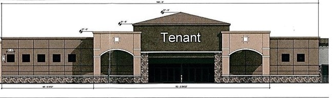
Regionalshoppingcenterormallwithanchorstore
Kern
C-2 PCD
California
B and X Area of moderate flood hazard, usually the area between the limits of the 100-year and 500-year floods.
10
2024
0.58 AC
2025
Northwest Bakersfield
003819
Bakersfield
3,640 SF
Bakersfield-Delano, CA
NEARBY LISTINGS FOR SALE OR LEASE
-
-
SWC Stockdale Highway & Buena Vista Road Hwy @ Buena Vista Toad
Bakersfield, CA 93311
Negotiable
3,300 SF
Retail
-
-
-
-
View all Bakersfield listings for lease on LoopNet.com
DEMOGRAPHICS near 12926 Brimhall Rd
1 mile
3 mile
5 mile
2025 Total Population
8,977
76,314
167,013
2030 Population
9,053
78,316
169,885
Pop Growth 2025-2030
+ 0.85%
+ 2.62%
+ 1.72%
Average Age
41
38
38
2025 Total Households
3,064
25,082
56,202
HH Growth 2025-2030
+ 0.69%
+ 2.52%
+ 1.64%
Median Household Inc
$119,136
$120,485
$112,448
Avg Household Size
2.90
3.00
2.90
2025 Avg HH Vehicles
3.00
2.00
2.00
Median Home Value
$586,657
$469,019
$445,060
Median Year Built
2000
2001
1998
Nearby Places
Map Layers
Map Styles
 Street
 Aerial
Layers
 Traffic
 Biking
Places
Listings with unknown addresses are not visible on the map
- Restaurants
- Banks
- Shops
- Fitness
- Groceries
PUBLIC TRANSPORTATION
COMMUTER RAIL
Drive
Walk
Distance
17 min
9.6 mi
AIRPORT
Meadows Field
Drive
Walk
Distance
Meadows Field
23 min
11.8 mi
SALE & LEASE HISTORY
LISTING DATE
SALE/LEASE

Sep 25, 2016
For Lease
Nearby Properties
Address
Land Use
TOTAL SIZE
Lot Size
Zoning
Address
Land Use
TOTAL SIZE
Lot Size
Zoning
319,531 SF
17.66 AC
R3
Address
Land Use
TOTAL SIZE
Lot Size
Zoning
6,702 SF
18.75 AC
C-2
Address
Land Use
TOTAL SIZE
Lot Size
Zoning
241,051 SF
18.48 AC
CO
Address
Land Use
TOTAL SIZE
Lot Size
Zoning
7,008 SF
46 AC
R1
Address
Land Use
TOTAL SIZE
Lot Size
Zoning
35,250 SF
10.33 AC
C-2 PCD
Address
Land Use
TOTAL SIZE
Lot Size
Zoning
149,197 SF
8.21 AC
PUD
Address
Land Use
TOTAL SIZE
Lot Size
Zoning
51,517 SF
8.11 AC
CO
Address
Land Use
TOTAL SIZE
Lot Size
Zoning
99,368 SF
6.95 AC
CO
Address
Land Use
TOTAL SIZE
Lot Size
Zoning
138,923 SF
9.97 AC
C-2
Address
Land Use
TOTAL SIZE
Lot Size
Zoning
55,532 SF
4.18 AC
CO
Address
Land Use
TOTAL SIZE
Lot Size
Zoning
51,666 SF
6.08 AC
C2
Address
Land Use
TOTAL SIZE
Lot Size
Zoning
144,414 SF
11.90 AC
PCD
Address
Land Use
TOTAL SIZE
Lot Size
Zoning
55,586 SF
2.49 AC
C-O
Address
Land Use
TOTAL SIZE
Lot Size
Zoning
72,330 SF
2.59 AC
C-O
Address
Land Use
TOTAL SIZE
Lot Size
Zoning
73,055 SF
3.83 AC
PUD
Address
Land Use
TOTAL SIZE
Lot Size
Zoning
71,922 SF
4.99 AC
CO
Address
Land Use
TOTAL SIZE
Lot Size
Zoning
16,991 SF
17.46 AC
R1
Address
Land Use
TOTAL SIZE
Lot Size
Zoning
45,113 SF
2.68 AC
CO
Address
Land Use
TOTAL SIZE
Lot Size
Zoning
53,468 SF
3.80 AC
C-O
Address
Land Use
TOTAL SIZE
Lot Size
Zoning
86,729 SF
8.59 AC
C2
Address
Land Use
TOTAL SIZE
Lot Size
Zoning
115,058 SF
10.95 AC
Address
Land Use
TOTAL SIZE
Lot Size
Zoning
59,462 SF
4.80 AC
PUD
Address
Land Use
TOTAL SIZE
Lot Size
Zoning
1,860 SF
7.86 AC
Address
Land Use
TOTAL SIZE
Lot Size
Zoning
88,255 SF
6.24 AC
C-2
Address
Land Use
TOTAL SIZE
Lot Size
Zoning
71,922 SF
1.38 AC
CO
Address
Land Use
TOTAL SIZE
Lot Size
Zoning
237,350 SF
25.31 AC
C2
Address
Land Use
TOTAL SIZE
Lot Size
Zoning
17,376 SF
25.71 AC
R1
Address
Land Use
TOTAL SIZE
Lot Size
Zoning
575,291 SF
20.92 AC
CO
Address
Land Use
TOTAL SIZE
Lot Size
Zoning
46,344 SF
2.50 AC
CO
The World's #1 Commercial Real Estate Marketplace
Connect with us
© 2026 CoStar Group
The information above has been obtained from sources believed reliable. While we do not doubt its accuracy we have not verified it and make no guarantee, warranty or representation about it. It is your responsibility to independently confirm its accuracy and completeness. Any projections, opinions, assumptions, or estimates used are for example only and do not represent the current or future performance of the property. The value of this transaction to you depends on tax and other factors which should be evaluated by your tax, financial, and legal advisors. You and your advisors should conduct a careful, independent investigation of the property to determine to your satisfaction the suitability of the property for your needs.