Property Record
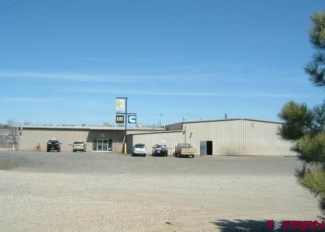
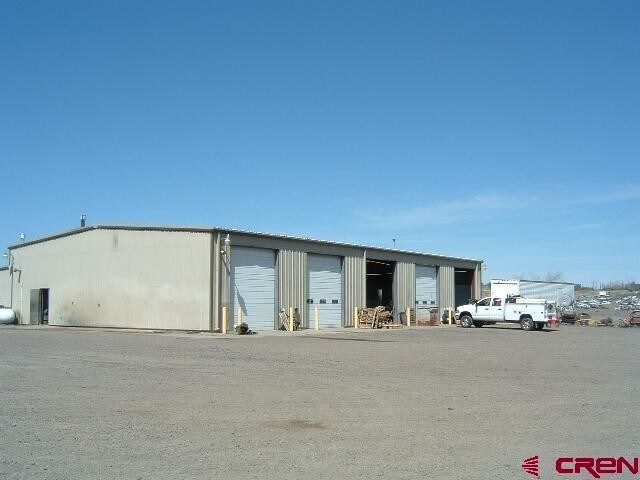
12936 Highway 491, Cortez, CO 81321

Property Detail
12936 Highway 491
Distributionwarehouseregional
SECTION: 9 TOWNSHIP: 36 RANGE: 16 TR IN NE1/4NW1/4 LESS LOTS & R/W 8.53AC, AKA WEST TRACT OF EXEMPTION PLAT GARY F. &
COMZ
MONTEZUMA
B and X Area of moderate flood hazard, usually the area between the limits of the 100-year and 500-year floods.
Colorado
2025
8.53 AC
2025
Colorado Southwest Area
969301
Other Market Areas
9,230 SF
R016825
NEARBY LISTINGS FOR SALE OR LEASE
DEMOGRAPHICS near 12936 Highway 491
1 mile
3 mile
5 mile
2025 Total Population
293
2,115
13,716
2030 Population
302
2,168
14,224
Pop Growth 2025-2030
+ 3.07%
+ 2.51%
+ 3.70%
Average Age
44
47
43
2025 Total Households
119
838
5,788
HH Growth 2025-2030
+ 2.52%
+ 2.74%
+ 3.71%
Median Household Inc
$82,000
$81,559
$66,159
Avg Household Size
2.30
2.30
2.30
2025 Avg HH Vehicles
2.00
2.00
2.00
Median Home Value
$333,333
$391,957
$313,802
Median Year Built
1980
1988
1979
Nearby Places
Map Layers
Map Styles
 Street
 Aerial
Transit
 Traffic
 Biking
Places
Listings with unknown addresses are not visible on the map
- Restaurants
- Banks
- Shops
- Fitness
- Groceries
SALE & LEASE HISTORY
LISTING DATE
SALE/LEASE

Sep 24, 2016
For Sale
Nearby Properties
Address
Land Use
TOTAL SIZE
Lot Size
Zoning
Address
Land Use
TOTAL SIZE
Lot Size
Zoning
76.87 AC
A/R 35+
Address
Land Use
TOTAL SIZE
Lot Size
Zoning
10,619 SF
8.20 AC
INDHZ
Address
Land Use
TOTAL SIZE
Lot Size
Zoning
16,276 SF
2.50 AC
I
Address
Land Use
TOTAL SIZE
Lot Size
Zoning
35.23 AC
A/R 10-34
Address
Land Use
TOTAL SIZE
Lot Size
Zoning
9.87 AC
INDHZ
Address
Land Use
TOTAL SIZE
Lot Size
Zoning
11.93 AC
A/R 10-34
Address
Land Use
TOTAL SIZE
Lot Size
Zoning
2,305 SF
47.10 AC
A/R 35+
Address
Land Use
TOTAL SIZE
Lot Size
Zoning
154.07 AC
A/R 35+
Address
Land Use
TOTAL SIZE
Lot Size
Zoning
8,000 SF
5.30 AC
INDLZ
Address
Land Use
TOTAL SIZE
Lot Size
Zoning
2,101 SF
4.87 AC
A/R 3-9
Address
Land Use
TOTAL SIZE
Lot Size
Zoning
1.38 AC
I
Address
Land Use
TOTAL SIZE
Lot Size
Zoning
4,800 SF
87.61 AC
A/R 35+
Address
Land Use
TOTAL SIZE
Lot Size
Zoning
8,196 SF
4.25 AC
COMZ
Address
Land Use
TOTAL SIZE
Lot Size
Zoning
28.27 AC
A/R 10-34
Address
Land Use
TOTAL SIZE
Lot Size
Zoning
7,920 SF
4 AC
INDLZ
Address
Land Use
TOTAL SIZE
Lot Size
Zoning
3,600 SF
160 AC
A-80+
Address
Land Use
TOTAL SIZE
Lot Size
Zoning
79.20 AC
A-80+
Address
Land Use
TOTAL SIZE
Lot Size
Zoning
13,464 SF
1.59 AC
I
Address
Land Use
TOTAL SIZE
Lot Size
Zoning
35.26 AC
A/R 35+
Address
Land Use
TOTAL SIZE
Lot Size
Zoning
2,700 SF
17.01 AC
A/R 10-34
Address
Land Use
TOTAL SIZE
Lot Size
Zoning
46.93 AC
INDHZ
Address
Land Use
TOTAL SIZE
Lot Size
Zoning
1,635 SF
35.29 AC
A/R 35+
Address
Land Use
TOTAL SIZE
Lot Size
Zoning
43.79 AC
A/R 35+
Address
Land Use
TOTAL SIZE
Lot Size
Zoning
57.26 AC
AGZ
Address
Land Use
TOTAL SIZE
Lot Size
Zoning
5,000 SF
2 AC
A/R 3-9
Address
Land Use
TOTAL SIZE
Lot Size
Zoning
6,270 SF
7.23 AC
INDLZ
Address
Land Use
TOTAL SIZE
Lot Size
Zoning
4,648 SF
1 AC
COMZ
Address
Land Use
TOTAL SIZE
Lot Size
Zoning
3.26 AC
A/R 3-9
Address
Land Use
TOTAL SIZE
Lot Size
Zoning
3,600 SF
17.96 AC
I
The World's #1 Commercial Real Estate Marketplace
Connect with us
© 2026 CoStar Group
The information above has been obtained from sources believed reliable. While we do not doubt its accuracy we have not verified it and make no guarantee, warranty or representation about it. It is your responsibility to independently confirm its accuracy and completeness. Any projections, opinions, assumptions, or estimates used are for example only and do not represent the current or future performance of the property. The value of this transaction to you depends on tax and other factors which should be evaluated by your tax, financial, and legal advisors. You and your advisors should conduct a careful, independent investigation of the property to determine to your satisfaction the suitability of the property for your needs.