Property Record
12950 Rolling Ridge Rd, Becker, MN 55308
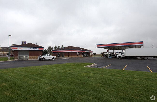

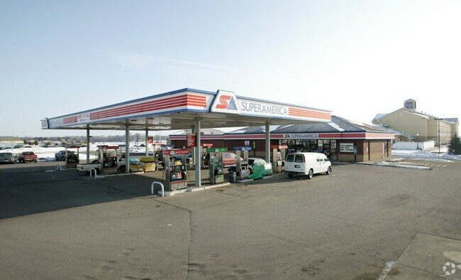
Property Detail
12950 Rolling Ridge Rd
Minneapolis-St. Paul-Bloomington, MN-WI
LOT 1 & NWLY 20 FT OF LOT 2 (AS MEASURED PERPENDICULAR TO SELY LINE OF LOT 1), BLK 2.
60-436-0205
Sherburne
Conveniencestore
Minnesota
B and X Area of moderate flood hazard, usually the area between the limits of the 100-year and 500-year floods.
1-2
2025
1.25 AC
2025
Sherburne County
030407
Minneapolis/St Paul
1,188 SF
NEARBY LISTINGS FOR SALE OR LEASE
DEMOGRAPHICS near 12950 Rolling Ridge Rd
1 mile
3 mile
5 mile
2025 Total Population
1,632
6,588
13,944
2030 Population
1,693
6,844
14,544
Pop Growth 2025-2030
+ 3.74%
+ 3.89%
+ 4.30%
Average Age
36
36
37
2025 Total Households
596
2,255
4,754
HH Growth 2025-2030
+ 3.86%
+ 3.99%
+ 4.48%
Median Household Inc
$94,642
$104,548
$111,006
Avg Household Size
2.70
2.90
2.90
2025 Avg HH Vehicles
2.00
2.00
2.00
Median Home Value
$327,717
$316,234
$339,796
Median Year Built
1999
2001
1998
Nearby Places
Map Layers
Map Styles
 Street
 Aerial
Layers
 Traffic
 Biking
Places
Listings with unknown addresses are not visible on the map
- Restaurants
- Banks
- Shops
- Fitness
- Groceries
PUBLIC TRANSPORTATION
COMMUTER RAIL
Big Lake Station (Northstar Corridor - Northstar Commuter Rail)
Drive
Walk
Distance
Big Lake Station (Northstar Corridor - Northstar Commuter Rail)
15 min
8.5 mi
Freight Ports
Port Milwaukee
Drive
Walk
Distance
Port Milwaukee
427 min
383.1 mi
Nearby Properties
Address
Land Use
TOTAL SIZE
Lot Size
Zoning
Address
Land Use
TOTAL SIZE
Lot Size
Zoning
261,267 SF
35.02 AC
Address
Land Use
TOTAL SIZE
Lot Size
Zoning
7,392 SF
15.87 AC
Address
Land Use
TOTAL SIZE
Lot Size
Zoning
71,441 SF
37.23 AC
Address
Land Use
TOTAL SIZE
Lot Size
Zoning
217,432 SF
3 AC
Address
Land Use
TOTAL SIZE
Lot Size
Zoning
280 SF
78.73 AC
Address
Land Use
TOTAL SIZE
Lot Size
Zoning
348.31 AC
Address
Land Use
TOTAL SIZE
Lot Size
Zoning
5,112 SF
29.98 AC
Address
Land Use
TOTAL SIZE
Lot Size
Zoning
1.40 AC
Address
Land Use
TOTAL SIZE
Lot Size
Zoning
1,600 SF
8.39 AC
Address
Land Use
TOTAL SIZE
Lot Size
Zoning
114,892 SF
9.38 AC
Address
Land Use
TOTAL SIZE
Lot Size
Zoning
3.12 AC
Address
Land Use
TOTAL SIZE
Lot Size
Zoning
3.25 AC
Address
Land Use
TOTAL SIZE
Lot Size
Zoning
3.10 AC
Address
Land Use
TOTAL SIZE
Lot Size
Zoning
3,780 SF
4.57 AC
Address
Land Use
TOTAL SIZE
Lot Size
Zoning
84,570 SF
9.22 AC
Address
Land Use
TOTAL SIZE
Lot Size
Zoning
313.42 AC
Address
Land Use
TOTAL SIZE
Lot Size
Zoning
312 SF
13.63 AC
Address
Land Use
TOTAL SIZE
Lot Size
Zoning
1,156 SF
5 AC
Address
Land Use
TOTAL SIZE
Lot Size
Zoning
2,334 SF
4.48 AC
Address
Land Use
TOTAL SIZE
Lot Size
Zoning
648 SF
42.88 AC
Address
Land Use
TOTAL SIZE
Lot Size
Zoning
262.30 AC
Address
Land Use
TOTAL SIZE
Lot Size
Zoning
24,528 SF
4.19 AC
Address
Land Use
TOTAL SIZE
Lot Size
Zoning
53,200 SF
3.87 AC
Address
Land Use
TOTAL SIZE
Lot Size
Zoning
14,860 SF
6.46 AC
Address
Land Use
TOTAL SIZE
Lot Size
Zoning
17,028 SF
5.75 AC
Address
Land Use
TOTAL SIZE
Lot Size
Zoning
14,372 SF
18.84 AC
The World's #1 Commercial Real Estate Marketplace
Connect with us
© 2026 CoStar Group
The information above has been obtained from sources believed reliable. While we do not doubt its accuracy we have not verified it and make no guarantee, warranty or representation about it. It is your responsibility to independently confirm its accuracy and completeness. Any projections, opinions, assumptions, or estimates used are for example only and do not represent the current or future performance of the property. The value of this transaction to you depends on tax and other factors which should be evaluated by your tax, financial, and legal advisors. You and your advisors should conduct a careful, independent investigation of the property to determine to your satisfaction the suitability of the property for your needs.