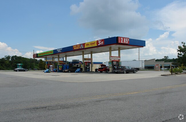
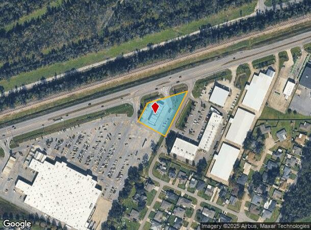
Property Record
12953 Highway 90, Luling, LA 70070

NEARBY LISTINGS FOR SALE OR LEASE
Property Detail
12953 Highway 90
New Orleans/Metairie/Kenner
Highway 90 Commercial
New Orleans-Metairie, LA
LOT RC-1-B-1, PRIMROSE ESATES (BEING A RESUBD. OF LOT RC-1-B & A PORTION OF A 2' WIDE STRIP LOCATED ON THE WEST SIDE OF WEST
7559000RC1B1
St Charles
Storebuilding
Louisiana
2025
rc-1-b
2025
1.09 AC
063100
St Charles Parish
1,404 SF
DEMOGRAPHICS near 12953 Highway 90
1 mile
3 mile
5 mile
2024 Total Population
4,044
16,004
32,141
2029 Population
3,881
15,449
31,131
Pop Growth 2024-2029
(4.03%)
(3.47%)
(3.14%)
Average Age
39
38
39
2024 Total Households
1,474
5,688
11,684
HH Growth 2024-2029
(3.93%)
(3.43%)
(3.07%)
Median Household Inc
$75,631
$76,973
$78,359
Avg Household Size
2.70
2.80
2.70
2024 Avg HH Vehicles
2.00
2.00
2.00
Median Home Value
$230,560
$243,570
$245,000
Median Year Built
1980
1985
1985
Nearby Places
Map Layers
Map Styles
 Street
 Aerial
Transit
 Traffic
 Biking
Places
Listings with unknown addresses are not visible on the map
- Restaurants
- Banks
- Shops
- Fitness
- Groceries
PUBLIC TRANSPORTATION
AIRPORT
Louis Armstrong New Orleans International
Drive
Walk
Distance
Louis Armstrong New Orleans International
21 min
15.9 mi
Freight Ports
Plaquemines Port
Drive
Walk
Distance
Plaquemines Port
36 min
25.2 mi
Nearby Properties
Address
Land Use
TOTAL SIZE
Lot Size
Zoning
Address
Land Use
TOTAL SIZE
Lot Size
Zoning
Address
Land Use
TOTAL SIZE
Lot Size
Zoning
Address
Land Use
TOTAL SIZE
Lot Size
Zoning
Address
Land Use
TOTAL SIZE
Lot Size
Zoning
Address
Land Use
TOTAL SIZE
Lot Size
Zoning
Address
Land Use
TOTAL SIZE
Lot Size
Zoning
48.33 AC
Address
Land Use
TOTAL SIZE
Lot Size
Zoning
Address
Land Use
TOTAL SIZE
Lot Size
Zoning
Address
Land Use
TOTAL SIZE
Lot Size
Zoning
1,425.06 AC
Address
Land Use
TOTAL SIZE
Lot Size
Zoning
3.17 AC
Address
Land Use
TOTAL SIZE
Lot Size
Zoning
Address
Land Use
TOTAL SIZE
Lot Size
Zoning
Address
Land Use
TOTAL SIZE
Lot Size
Zoning
Address
Land Use
TOTAL SIZE
Lot Size
Zoning
71,024 SF
28.36 AC
Address
Land Use
TOTAL SIZE
Lot Size
Zoning
62.34 AC
Address
Land Use
TOTAL SIZE
Lot Size
Zoning
10.50 AC
Address
Land Use
TOTAL SIZE
Lot Size
Zoning
Address
Land Use
TOTAL SIZE
Lot Size
Zoning
57,894 SF
4.43 AC
Address
Land Use
TOTAL SIZE
Lot Size
Zoning
4.60 AC
Address
Land Use
TOTAL SIZE
Lot Size
Zoning
Address
Land Use
TOTAL SIZE
Lot Size
Zoning
Address
Land Use
TOTAL SIZE
Lot Size
Zoning
28,711 SF
24.90 AC
Address
Land Use
TOTAL SIZE
Lot Size
Zoning
158,268 SF
16.50 AC
Address
Land Use
TOTAL SIZE
Lot Size
Zoning
Address
Land Use
TOTAL SIZE
Lot Size
Zoning
Address
Land Use
TOTAL SIZE
Lot Size
Zoning
Address
Land Use
TOTAL SIZE
Lot Size
Zoning
5.97 AC
Address
Land Use
TOTAL SIZE
Lot Size
Zoning
11.70 AC
Address
Land Use
TOTAL SIZE
Lot Size
Zoning
55,814 SF
6.76 AC
Address
Land Use
TOTAL SIZE
Lot Size
Zoning
The World's #1 Commercial Real Estate Marketplace
Connect with us
© 2026 CoStar Group
The information above has been obtained from sources believed reliable. While we do not doubt its accuracy we have not verified it and make no guarantee, warranty or representation about it. It is your responsibility to independently confirm its accuracy and completeness. Any projections, opinions, assumptions, or estimates used are for example only and do not represent the current or future performance of the property. The value of this transaction to you depends on tax and other factors which should be evaluated by your tax, financial, and legal advisors. You and your advisors should conduct a careful, independent investigation of the property to determine to your satisfaction the suitability of the property for your needs.