Property Record
12962 S Us 301 Hwy S, Riverview, FL 33579
NEARBY LISTINGS FOR SALE OR LEASE
Property Detail
12962 S Us 301 Hwy S
Tampa-St. Petersburg-Clearwater, FL
Unplatted
U-08-31-20-ZZZ-000003-13770.2
THAT PART OF SW 1/4 AND PART OF NW 1/4 OF SEC 8 DESC AS FOLLOWS: COMM AT NW COR OF LOT 1 OF SUMMERFIELD CROSSINGS COMMERCIAL PHASE 2 PB 104 PG 89 RUN N 00 DEG 20 MIN 29 SEC E 100 FT TO POB THN N 00 DEG 20 MIN 29 SEC E 818.59 FT TO PC TO RT W/RAD 5597
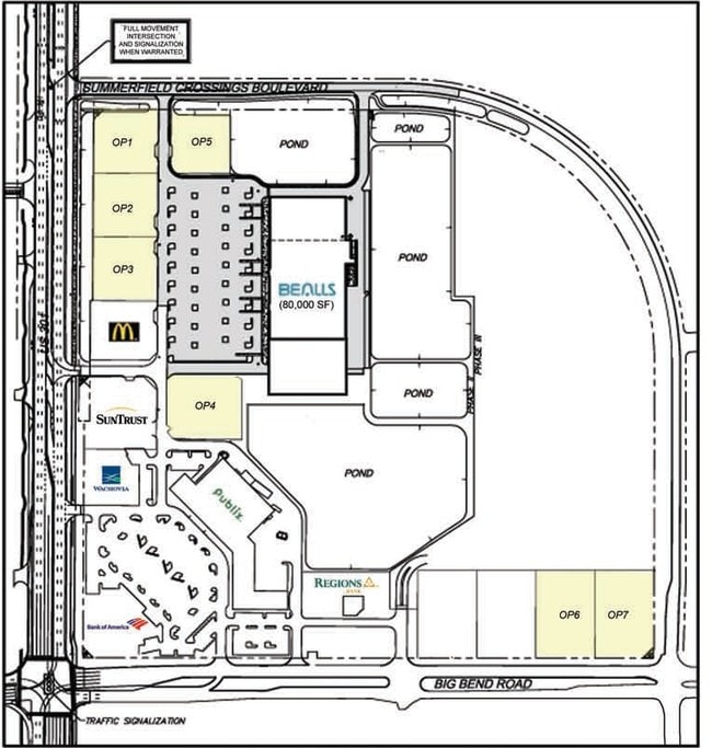
Regionalshoppingcenterormallwithanchorstore
Hillsborough
X
Florida
12057C0515H
13770
2024
17.86 AC
2024
Eastern Outlying
013917
Tampa/St Petersburg
67,560 SF
DEMOGRAPHICS near 12962 S Us 301 Hwy S
1 Mile
3 Mile
5 Mile
2024 Total Population
12,240
87,224
162,763
2029 Population
13,435
96,419
181,178
Pop Growth 2024-2029
+ 9.76%
+ 10.54%
+ 11.31%
Average Age
35
36
37
2024 Total Households
4,011
28,511
55,372
HH Growth 2024-2029
+ 9.95%
+ 10.77%
+ 11.50%
Median Household Inc
$93,155
$91,837
$88,760
Avg Household Size
3.00
3.00
2.90
2024 Avg HH Vehicles
2.00
2.00
2.00
Median Home Value
$267,819
$284,822
$293,559
Median Year Built
2008
2010
2009
Nearby Places
Map Layers
Map Styles
 Street
 Aerial
- Restaurants
- Banks
- Shops
- Fitness
- Groceries
PUBLIC TRANSPORTATION
AIRPORT
Tampa International
DRIVE
WALK
Distance
Tampa International
39 min
25.9 mi
St Pete-Clearwater International
DRIVE
WALK
Distance
St Pete-Clearwater International
57 min
35.2 mi
Freight Ports
Port of Tampa Bay
DRIVE
WALK
Distance
Port of Tampa Bay
27 min
15.9 mi
Nearby Properties
Address
Land Use
TOTAL SIZE
Lot Size
Zoning
Address
Land Use
TOTAL SIZE
Lot Size
Zoning
647,720 SF
68.52 AC
PD
Address
Land Use
TOTAL SIZE
Lot Size
Zoning
289,173 SF
54.08 AC
PD
Address
Land Use
TOTAL SIZE
Lot Size
Zoning
419,897 SF
18.09 AC
PD
Address
Land Use
TOTAL SIZE
Lot Size
Zoning
317,172 SF
36.54 AC
PD
Address
Land Use
TOTAL SIZE
Lot Size
Zoning
345,018 SF
15.43 AC
PD
Address
Land Use
TOTAL SIZE
Lot Size
Zoning
382,614 SF
23.72 AC
IPD-1
Address
Land Use
TOTAL SIZE
Lot Size
Zoning
334,871 SF
15 AC
PD
Address
Land Use
TOTAL SIZE
Lot Size
Zoning
425,231 SF
23.78 AC
M
Address
Land Use
TOTAL SIZE
Lot Size
Zoning
124,865 SF
20.14 AC
PD
Address
Land Use
TOTAL SIZE
Lot Size
Zoning
101,768 SF
17.94 AC
PD
Address
Land Use
TOTAL SIZE
Lot Size
Zoning
441,257 SF
107.09 AC
AR
Address
Land Use
TOTAL SIZE
Lot Size
Zoning
102,925 SF
24.56 AC
PD
Address
Land Use
TOTAL SIZE
Lot Size
Zoning
164,852 SF
15.26 AC
PD
Address
Land Use
TOTAL SIZE
Lot Size
Zoning
74,246 SF
9.75 AC
AR
Address
Land Use
TOTAL SIZE
Lot Size
Zoning
68,826 SF
10.14 AC
PD
Address
Land Use
TOTAL SIZE
Lot Size
Zoning
67,026 SF
21.92 AC
PD
Address
Land Use
TOTAL SIZE
Lot Size
Zoning
71,836 SF
42.82 AC
ASC-1
Address
Land Use
TOTAL SIZE
Lot Size
Zoning
101,809 SF
15.02 AC
PD
Address
Land Use
TOTAL SIZE
Lot Size
Zoning
98,325 SF
20.75 AC
PD
Address
Land Use
TOTAL SIZE
Lot Size
Zoning
68,942 SF
10.69 AC
PD
Address
Land Use
TOTAL SIZE
Lot Size
Zoning
88,445 SF
14.41 AC
PD
Address
Land Use
TOTAL SIZE
Lot Size
Zoning
87,925 SF
4.38 AC
PD
Address
Land Use
TOTAL SIZE
Lot Size
Zoning
113,296 SF
23.90 AC
PD
Address
Land Use
TOTAL SIZE
Lot Size
Zoning
75,207 SF
8.57 AC
PD
Address
Land Use
TOTAL SIZE
Lot Size
Zoning
81,193 SF
11.41 AC
PD
Address
Land Use
TOTAL SIZE
Lot Size
Zoning
79,150 SF
14.65 AC
PD
Address
Land Use
TOTAL SIZE
Lot Size
Zoning
63,316 SF
12.44 AC
PD
Address
Land Use
TOTAL SIZE
Lot Size
Zoning
138,316 SF
13.27 AC
PD
Address
Land Use
TOTAL SIZE
Lot Size
Zoning
110,148 SF
23.04 AC
M
The World's #1 Commercial Real Estate Marketplace
Connect with us
© 2026 CoStar Group
The information above has been obtained from sources believed reliable. While we do not doubt its accuracy we have not verified it and make no guarantee, warranty or representation about it. It is your responsibility to independently confirm its accuracy and completeness. Any projections, opinions, assumptions, or estimates used are for example only and do not represent the current or future performance of the property. The value of this transaction to you depends on tax and other factors which should be evaluated by your tax, financial, and legal advisors. You and your advisors should conduct a careful, independent investigation of the property to determine to your satisfaction the suitability of the property for your needs.