Property Record
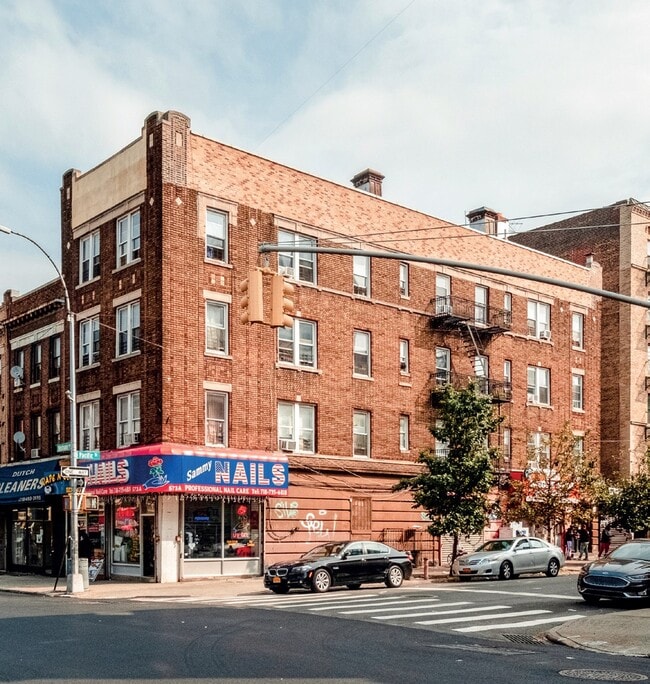
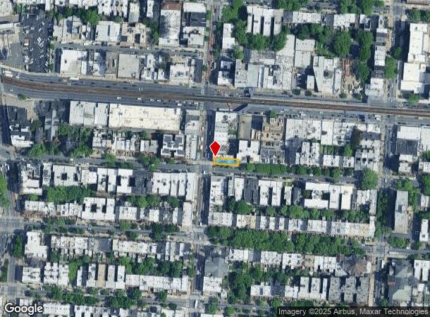
573 Nostrand Ave, Brooklyn, NY 11216
NEARBY LISTINGS FOR SALE OR LEASE
Property Detail
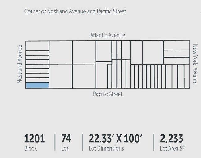
573 Nostrand Ave
01201-0074
DOCID-2021031500714001
Commercialofficeresidentialmixeduse
Kings
X
New York
3604970212F
74
2024
0.05 AC
2025
Crown Heights
031500
Long Island (New York)
8,218 SF
New York-Jersey City-White Plains, NY-NJ
DEMOGRAPHICS near 573 Nostrand Ave
1 mile
3 mile
5 mile
2024 Total Population
189,425
1,343,695
2,774,171
2029 Population
179,393
1,272,828
2,592,839
Pop Growth 2024-2029
(5.30%)
(5.27%)
(6.54%)
Average Age
38
38
38
2024 Total Households
77,960
522,671
1,075,060
HH Growth 2024-2029
(5.81%)
(5.70%)
(6.79%)
Median Household Inc
$81,446
$75,684
$77,268
Avg Household Size
2.30
2.40
2.50
2024 Avg HH Vehicles
.00
.00
.00
Median Home Value
$1,040,378
$934,613
$857,322
Median Year Built
1947
1948
1948
Nearby Places
Map Layers
Map Styles
 Street
 Aerial
Transit
 Traffic
 Biking
Places
Listings with unknown addresses are not visible on the map
- Restaurants
- Banks
- Shops
- Fitness
- Groceries
PUBLIC TRANSPORTATION
TRANSIT/SUBWAY
Nostrand Avenue Station (Far Rockaway Branch - Long Island Rail Road, Hempstead Branch - Long Island Rail Road, Long Beach Branch - Long Island Rail Road, West Hempstead Branch - Long Island Rail Road)
Drive
Walk
Distance
Nostrand Avenue Station (Far Rockaway Branch - Long Island Rail Road, Hempstead Branch - Long Island Rail Road, Long Beach Branch - Long Island Rail Road, West Hempstead Branch - Long Island Rail Road)
2 min
2 min
0.1 mi
Nostrand Avenue (A,C Line) (A - New York MTA Subway (The Subway), C - New York MTA Subway (The Subway))
Drive
Walk
Distance
Nostrand Avenue (A,C Line) (A - New York MTA Subway (The Subway), C - New York MTA Subway (The Subway))
2 min
4 min
0.2 mi
Franklin Avenue (A,C,S Line) (A - New York MTA Subway (The Subway), C - New York MTA Subway (The Subway), Franklin Avenue Shuttle - New York MTA Subway (The Subway))
Drive
Walk
Distance
Franklin Avenue (A,C,S Line) (A - New York MTA Subway (The Subway), C - New York MTA Subway (The Subway), Franklin Avenue Shuttle - New York MTA Subway (The Subway))
2 min
9 min
0.5 mi
Kingston-Throop Avenues (A - New York MTA Subway (The Subway), C - New York MTA Subway (The Subway))
Drive
Walk
Distance
Kingston-Throop Avenues (A - New York MTA Subway (The Subway), C - New York MTA Subway (The Subway))
3 min
12 min
0.6 mi
Park Place (S Line) (Franklin Avenue Shuttle - New York MTA Subway (The Subway))
Drive
Walk
Distance
Park Place (S Line) (Franklin Avenue Shuttle - New York MTA Subway (The Subway))
4 min
13 min
0.7 mi
COMMUTER RAIL
Nostrand Avenue Station (Far Rockaway Branch - Long Island Rail Road, Hempstead Branch - Long Island Rail Road, Long Beach Branch - Long Island Rail Road, West Hempstead Branch - Long Island Rail Road)
Drive
Walk
Distance
Nostrand Avenue Station (Far Rockaway Branch - Long Island Rail Road, Hempstead Branch - Long Island Rail Road, Long Beach Branch - Long Island Rail Road, West Hempstead Branch - Long Island Rail Road)
2 min
3 min
0.1 mi
Drive
Walk
Distance
5 min
1.5 mi
AIRPORT
LaGuardia
Drive
Walk
Distance
LaGuardia
21 min
10.4 mi
John F Kennedy International
Drive
Walk
Distance
John F Kennedy International
24 min
12.1 mi
Newark Liberty International
Drive
Walk
Distance
Newark Liberty International
31 min
16.9 mi
Freight Ports
NY - Red Hook Container Terminal
Drive
Walk
Distance
NY - Red Hook Container Terminal
12 min
3.5 mi
SALE & LEASE HISTORY
LISTING DATE
SALE/LEASE

Sep 11, 2020
For Sale
Jul 31, 2020
For Lease
Jan 03, 2018
For Lease
Aug 15, 2019
For Sale
Nearby Properties
Address
Land Use
TOTAL SIZE
Lot Size
Zoning
Address
Land Use
TOTAL SIZE
Lot Size
Zoning
2,812,739 SF
2.10 AC
C5-3
Address
Land Use
TOTAL SIZE
Lot Size
Zoning
7,058,736 SF
147.61 AC
M3-1
Address
Land Use
TOTAL SIZE
Lot Size
Zoning
869,038 SF
1.53 AC
M1-1
Address
Land Use
TOTAL SIZE
Lot Size
Zoning
92,440 SF
466.23 AC
R5
Address
Land Use
TOTAL SIZE
Lot Size
Zoning
923,000 SF
4.87 AC
R7-2
Address
Land Use
TOTAL SIZE
Lot Size
Zoning
923,000 SF
4.87 AC
R7-2
Address
Land Use
TOTAL SIZE
Lot Size
Zoning
923,000 SF
4.87 AC
R7-2
Address
Land Use
TOTAL SIZE
Lot Size
Zoning
923,000 SF
4.87 AC
R7-2
Address
Land Use
TOTAL SIZE
Lot Size
Zoning
923,000 SF
4.87 AC
R7-2
Address
Land Use
TOTAL SIZE
Lot Size
Zoning
923,000 SF
4.87 AC
R7-2
Address
Land Use
TOTAL SIZE
Lot Size
Zoning
923,000 SF
4.87 AC
R7-2
Address
Land Use
TOTAL SIZE
Lot Size
Zoning
923,000 SF
4.87 AC
R7-2
Address
Land Use
TOTAL SIZE
Lot Size
Zoning
923,000 SF
4.87 AC
R7-2
Address
Land Use
TOTAL SIZE
Lot Size
Zoning
923,000 SF
4.87 AC
R7-2
Address
Land Use
TOTAL SIZE
Lot Size
Zoning
923,000 SF
4.87 AC
R7-2
Address
Land Use
TOTAL SIZE
Lot Size
Zoning
923,000 SF
4.87 AC
R7-2
Address
Land Use
TOTAL SIZE
Lot Size
Zoning
923,000 SF
4.87 AC
R7-2
Address
Land Use
TOTAL SIZE
Lot Size
Zoning
923,000 SF
4.87 AC
R7-2
Address
Land Use
TOTAL SIZE
Lot Size
Zoning
923,000 SF
4.87 AC
R7-2
Address
Land Use
TOTAL SIZE
Lot Size
Zoning
923,000 SF
4.87 AC
R7-2
Address
Land Use
TOTAL SIZE
Lot Size
Zoning
923,000 SF
4.87 AC
R7-2
Address
Land Use
TOTAL SIZE
Lot Size
Zoning
923,000 SF
4.87 AC
R7-2
Address
Land Use
TOTAL SIZE
Lot Size
Zoning
923,000 SF
4.87 AC
R7-2
Address
Land Use
TOTAL SIZE
Lot Size
Zoning
923,000 SF
4.87 AC
R7-2
Address
Land Use
TOTAL SIZE
Lot Size
Zoning
923,000 SF
4.87 AC
R7-2
Address
Land Use
TOTAL SIZE
Lot Size
Zoning
923,000 SF
4.87 AC
R7-2
Address
Land Use
TOTAL SIZE
Lot Size
Zoning
923,000 SF
4.87 AC
R7-2
Address
Land Use
TOTAL SIZE
Lot Size
Zoning
923,000 SF
4.87 AC
R7-2
Address
Land Use
TOTAL SIZE
Lot Size
Zoning
923,000 SF
4.87 AC
R7-2
Address
Land Use
TOTAL SIZE
Lot Size
Zoning
923,000 SF
4.87 AC
R7-2
The World's #1 Commercial Real Estate Marketplace
Connect with us
© 2026 CoStar Group
The information above has been obtained from sources believed reliable. While we do not doubt its accuracy we have not verified it and make no guarantee, warranty or representation about it. It is your responsibility to independently confirm its accuracy and completeness. Any projections, opinions, assumptions, or estimates used are for example only and do not represent the current or future performance of the property. The value of this transaction to you depends on tax and other factors which should be evaluated by your tax, financial, and legal advisors. You and your advisors should conduct a careful, independent investigation of the property to determine to your satisfaction the suitability of the property for your needs.