No Photo
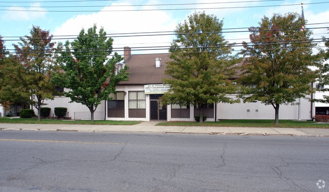
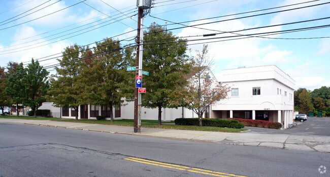
Property Record
1297 Arthur Kill Rd, Staten Island, NY 10312

NEARBY LISTINGS FOR SALE OR LEASE
-
-
View all Staten Island listings for sale on LoopNet.com
Property Detail
1297 Arthur Kill Rd
05900-0105
Staten Island
Communitycenter
New York
X
105
3604970308F
1.98 AC
0
Staten Island
2025
Long Island (New York)
022801
New York-Jersey City-White Plains, NY-NJ
24,000 SF
DEMOGRAPHICS near 1297 Arthur Kill Rd
1 Mile
3 Mile
5 Mile
2024 Total Population
14,961
173,937
356,630
2029 Population
14,813
170,635
350,746
Pop Growth 2024-2029
(0.99%)
(1.90%)
(1.65%)
Average Age
41
42
41
2024 Total Households
5,120
62,035
124,682
HH Growth 2024-2029
(1.15%)
(1.96%)
(1.72%)
Median Household Inc
$103,568
$98,620
$94,968
Avg Household Size
2.90
2.80
2.80
2024 Avg HH Vehicles
2.00
2.00
2.00
Median Home Value
$585,069
$647,911
$628,041
Median Year Built
1986
1979
1975
Nearby Places
Map Layers
Map Styles
 Street
 Aerial
- Restaurants
- Banks
- Shops
- Fitness
- Groceries
PUBLIC TRANSPORTATION
COMMUTER RAIL
Annadale (Staten Island Railway - New York MTA Subway (The Subway))
DRIVE
WALK
Distance
Annadale (Staten Island Railway - New York MTA Subway (The Subway))
5 min
2.0 mi
Eltingville (Staten Island Railway - New York MTA Subway (The Subway))
DRIVE
WALK
Distance
Eltingville (Staten Island Railway - New York MTA Subway (The Subway))
5 min
2.1 mi
AIRPORT
Newark Liberty International
DRIVE
WALK
Distance
Newark Liberty International
28 min
16.9 mi
LaGuardia
DRIVE
WALK
Distance
LaGuardia
50 min
28.5 mi
John F Kennedy International
DRIVE
WALK
Distance
John F Kennedy International
49 min
31.2 mi
Freight Ports
New York Container Terminal
DRIVE
WALK
Distance
New York Container Terminal
13 min
7.5 mi
Nearby Properties
Address
Land Use
TOTAL SIZE
Lot Size
Zoning
Address
Land Use
TOTAL SIZE
Lot Size
Zoning
3,600 SF
731.18 AC
PARK
Address
Land Use
TOTAL SIZE
Lot Size
Zoning
196.03 AC
HIA
Address
Land Use
TOTAL SIZE
Lot Size
Zoning
794,430 SF
36.09 AC
R50
Address
Land Use
TOTAL SIZE
Lot Size
Zoning
237 AC
M1-1
Address
Land Use
TOTAL SIZE
Lot Size
Zoning
118 AC
M3-1
Address
Land Use
TOTAL SIZE
Lot Size
Zoning
404,985 SF
15.32 AC
R25
Address
Land Use
TOTAL SIZE
Lot Size
Zoning
1,258,042 SF
14.47 AC
C4-1
Address
Land Use
TOTAL SIZE
Lot Size
Zoning
196,382 SF
25.95 AC
Address
Land Use
TOTAL SIZE
Lot Size
Zoning
360,082 SF
22.45 AC
R50
Address
Land Use
TOTAL SIZE
Lot Size
Zoning
365,784 SF
12.73 AC
HIA
Address
Land Use
TOTAL SIZE
Lot Size
Zoning
146 AC
PARK
Address
Land Use
TOTAL SIZE
Lot Size
Zoning
286,290 SF
21.24 AC
R50
Address
Land Use
TOTAL SIZE
Lot Size
Zoning
1.64 AC
R-25
Address
Land Use
TOTAL SIZE
Lot Size
Zoning
245,272 SF
18.54 AC
R50
Address
Land Use
TOTAL SIZE
Lot Size
Zoning
263,925 SF
11.98 AC
R50
Address
Land Use
TOTAL SIZE
Lot Size
Zoning
7.24 AC
Address
Land Use
TOTAL SIZE
Lot Size
Zoning
411,000 SF
18.54 AC
R3X
Address
Land Use
TOTAL SIZE
Lot Size
Zoning
131.25 AC
PARK
Address
Land Use
TOTAL SIZE
Lot Size
Zoning
55.47 AC
Address
Land Use
TOTAL SIZE
Lot Size
Zoning
21,120 SF
14.45 AC
R50
Address
Land Use
TOTAL SIZE
Lot Size
Zoning
5,214 SF
93 AC
M3-1
Address
Land Use
TOTAL SIZE
Lot Size
Zoning
214,392 SF
11.79 AC
R50
Address
Land Use
TOTAL SIZE
Lot Size
Zoning
Address
Land Use
TOTAL SIZE
Lot Size
Zoning
Address
Land Use
TOTAL SIZE
Lot Size
Zoning
195,395 SF
12.04 AC
R3-2
Address
Land Use
TOTAL SIZE
Lot Size
Zoning
262,455 SF
7.01 AC
R50
Address
Land Use
TOTAL SIZE
Lot Size
Zoning
418,012 SF
6.74 AC
R3-1
Address
Land Use
TOTAL SIZE
Lot Size
Zoning
11,140 SF
170.60 AC
PARK
Address
Land Use
TOTAL SIZE
Lot Size
Zoning
38.58 AC
PARK
Address
Land Use
TOTAL SIZE
Lot Size
Zoning
134,507 SF
8.47 AC
R50
The World's #1 Commercial Real Estate Marketplace
Connect with us
© 2026 CoStar Group
The information above has been obtained from sources believed reliable. While we do not doubt its accuracy we have not verified it and make no guarantee, warranty or representation about it. It is your responsibility to independently confirm its accuracy and completeness. Any projections, opinions, assumptions, or estimates used are for example only and do not represent the current or future performance of the property. The value of this transaction to you depends on tax and other factors which should be evaluated by your tax, financial, and legal advisors. You and your advisors should conduct a careful, independent investigation of the property to determine to your satisfaction the suitability of the property for your needs.