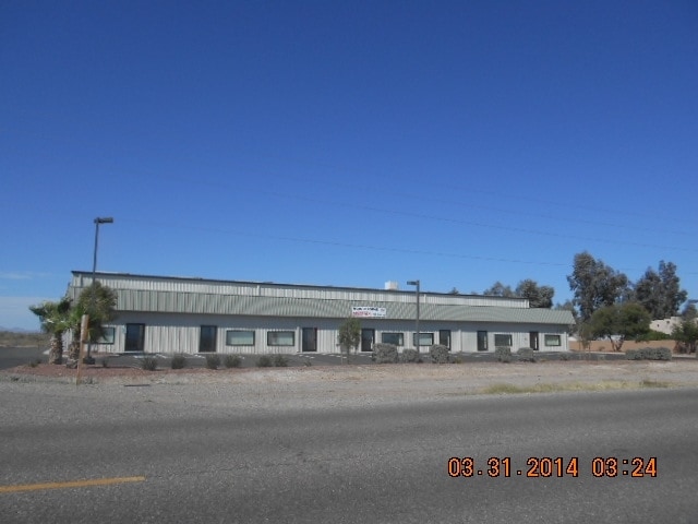
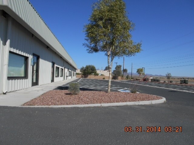
Property Record
1297 E Boundary Cone Rd, Mohave Valley, AZ 86440

Property Detail
1297 E Boundary Cone Rd
Lake Havasu City-Kingman, AZ
T18N R22W SEC 3 PORTION OF GOVT LOT 5 KNOWN AS PARCEL A OF RS 34 /44 REC 02/12/2007 #2007-13230 CONT 74,473.02 SQ FT OR 1.71 ACRES 225-19-020 (225-19-036 & 037) 2009 TAX ROLL
225-19-036
Mohave
Warehouse
Arizona
C and X Area of minimal flood hazard, usually depicted on FIRMs as above the 500-year flood level.
5
2025
1.71 AC
2027
Prescott & Sedona
940501
Other Market Areas
18,081 SF
NEARBY LISTINGS FOR SALE OR LEASE
DEMOGRAPHICS near 1297 E Boundary Cone Rd
1 mile
3 mile
5 mile
2025 Total Population
357
11,476
21,492
2030 Population
377
12,189
22,706
Pop Growth 2025-2030
+ 5.60%
+ 6.21%
+ 5.65%
Average Age
52
50
50
2025 Total Households
153
4,817
9,125
HH Growth 2025-2030
+ 5.23%
+ 6.35%
+ 5.80%
Median Household Inc
$72,187
$69,324
$60,993
Avg Household Size
2.40
2.40
2.30
2025 Avg HH Vehicles
2.00
2.00
2.00
Median Home Value
$320,689
$328,047
$296,216
Median Year Built
2002
2002
1999
Nearby Places
Map Layers
Map Styles
 Street
 Aerial
Layers
 Traffic
 Biking
Places
Listings with unknown addresses are not visible on the map
- Restaurants
- Banks
- Shops
- Fitness
- Groceries
PUBLIC TRANSPORTATION
COMMUTER RAIL
Needles Amtrak (Southwest Chief - Amtrak)
Drive
Walk
Distance
Needles Amtrak (Southwest Chief - Amtrak)
16 min
9.9 mi
AIRPORT
Laughlin/Bullhead International
Drive
Walk
Distance
Laughlin/Bullhead International
30 min
17.2 mi
Freight Ports
Port of San Diego
Drive
Walk
Distance
Port of San Diego
369 min
329.1 mi
Nearby Properties
Address
Land Use
TOTAL SIZE
Lot Size
Zoning
Address
Land Use
TOTAL SIZE
Lot Size
Zoning
153,593 SF
29.48 AC
Address
Land Use
TOTAL SIZE
Lot Size
Zoning
56,863 SF
15.46 AC
Address
Land Use
TOTAL SIZE
Lot Size
Zoning
160,248 SF
21.83 AC
Address
Land Use
TOTAL SIZE
Lot Size
Zoning
198,240 SF
18.79 AC
Address
Land Use
TOTAL SIZE
Lot Size
Zoning
176,053 SF
30.83 AC
Address
Land Use
TOTAL SIZE
Lot Size
Zoning
17,981 SF
6.25 AC
Address
Land Use
TOTAL SIZE
Lot Size
Zoning
36,278 SF
9.36 AC
Address
Land Use
TOTAL SIZE
Lot Size
Zoning
24,425 SF
5.21 AC
Address
Land Use
TOTAL SIZE
Lot Size
Zoning
16,905 SF
2.22 AC
Address
Land Use
TOTAL SIZE
Lot Size
Zoning
10,527 SF
5 AC
Address
Land Use
TOTAL SIZE
Lot Size
Zoning
13,880 SF
0.87 AC
Address
Land Use
TOTAL SIZE
Lot Size
Zoning
42,878 SF
2.65 AC
Address
Land Use
TOTAL SIZE
Lot Size
Zoning
41,250 SF
2.19 AC
Address
Land Use
TOTAL SIZE
Lot Size
Zoning
19,894 SF
66.83 AC
Address
Land Use
TOTAL SIZE
Lot Size
Zoning
10,790 SF
1.59 AC
Address
Land Use
TOTAL SIZE
Lot Size
Zoning
20,034 SF
0.81 AC
Address
Land Use
TOTAL SIZE
Lot Size
Zoning
8,044 SF
0.99 AC
Address
Land Use
TOTAL SIZE
Lot Size
Zoning
60,944 SF
4.61 AC
Address
Land Use
TOTAL SIZE
Lot Size
Zoning
15,300 SF
1.09 AC
Address
Land Use
TOTAL SIZE
Lot Size
Zoning
7,939 SF
1.46 AC
Address
Land Use
TOTAL SIZE
Lot Size
Zoning
15,384 SF
1.48 AC
Address
Land Use
TOTAL SIZE
Lot Size
Zoning
8,332 SF
1.05 AC
Address
Land Use
TOTAL SIZE
Lot Size
Zoning
1,035 SF
9.20 AC
Address
Land Use
TOTAL SIZE
Lot Size
Zoning
13,405 SF
1.01 AC
Address
Land Use
TOTAL SIZE
Lot Size
Zoning
1,056 SF
35.77 AC
Address
Land Use
TOTAL SIZE
Lot Size
Zoning
8,320 SF
5.19 AC
Address
Land Use
TOTAL SIZE
Lot Size
Zoning
14,020 SF
1.06 AC
Address
Land Use
TOTAL SIZE
Lot Size
Zoning
22,300 SF
2.50 AC
Address
Land Use
TOTAL SIZE
Lot Size
Zoning
14,423 SF
1.01 AC
The World's #1 Commercial Real Estate Marketplace
Connect with us
© 2026 CoStar Group
The information above has been obtained from sources believed reliable. While we do not doubt its accuracy we have not verified it and make no guarantee, warranty or representation about it. It is your responsibility to independently confirm its accuracy and completeness. Any projections, opinions, assumptions, or estimates used are for example only and do not represent the current or future performance of the property. The value of this transaction to you depends on tax and other factors which should be evaluated by your tax, financial, and legal advisors. You and your advisors should conduct a careful, independent investigation of the property to determine to your satisfaction the suitability of the property for your needs.