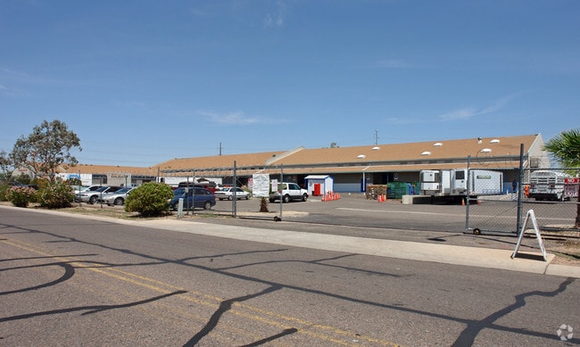
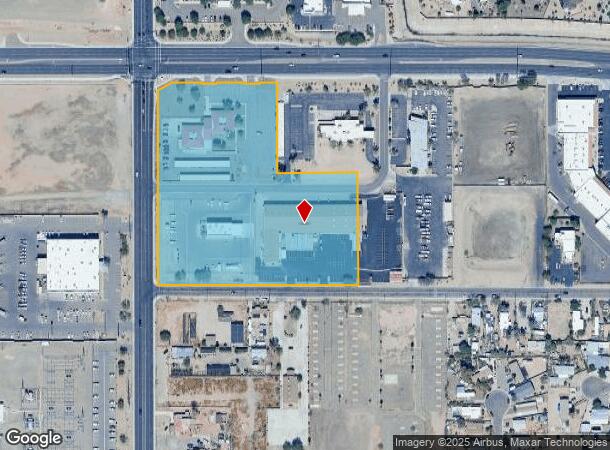
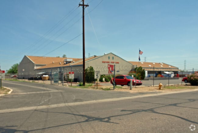
Property Record
12975 W Bell Rd, Surprise, AZ 85378
NEARBY LISTINGS FOR SALE OR LEASE
Property Detail
12975 W Bell Rd
501-18-019C
N 693F OF W 693F OF NW4 EX N 55F & W 40F RD & EX S 30F RD & EX P/F 98-229189 EX A POR DAF COM AT NW COR SD SEC TH E 40F TH S 55F TPOB TH E 391.46F TO PT LABELED PT A TH S 10F TH W 56.82 TH S 5F TH W 50F TH N 5F TH W 91.12F TH S 5F TH W 50F TH N 5F TH
Countyproperty
Maricopa
X
Arizona
04013C1240L
8.12 AC
0
Surprise
2025
Phoenix
060801
Phoenix-Mesa-Chandler, AZ
47,063 SF
DEMOGRAPHICS near 12975 W Bell Rd
1 Mile
3 Mile
5 Mile
2024 Total Population
11,367
99,268
236,414
2029 Population
12,337
107,877
256,912
Pop Growth 2024-2029
+ 8.53%
+ 8.67%
+ 8.67%
Average Age
48
46
50
2024 Total Households
4,591
39,503
100,864
HH Growth 2024-2029
+ 8.39%
+ 8.96%
+ 8.95%
Median Household Inc
$54,902
$64,951
$66,825
Avg Household Size
2.30
2.40
2.30
2024 Avg HH Vehicles
2.00
2.00
2.00
Median Home Value
$258,723
$298,117
$317,672
Median Year Built
1988
1997
1996
Nearby Places
Map Layers
Map Styles
 Street
 Aerial
- Restaurants
- Banks
- Shops
- Fitness
- Groceries
PUBLIC TRANSPORTATION
AIRPORT
Phoenix Sky Harbor International
DRIVE
WALK
Distance
Phoenix Sky Harbor International
46 min
32.9 mi
Nearby Properties
Address
Land Use
TOTAL SIZE
Lot Size
Zoning
Address
Land Use
TOTAL SIZE
Lot Size
Zoning
290,294 SF
61.52 AC
PAD
Address
Land Use
TOTAL SIZE
Lot Size
Zoning
53.02 AC
Address
Land Use
TOTAL SIZE
Lot Size
Zoning
630,234 SF
27.51 AC
Address
Land Use
TOTAL SIZE
Lot Size
Zoning
575,121 SF
73.01 AC
PAD
Address
Land Use
TOTAL SIZE
Lot Size
Zoning
197,699 SF
40.78 AC
PAD
Address
Land Use
TOTAL SIZE
Lot Size
Zoning
548,535 SF
15.45 AC
C-T
Address
Land Use
TOTAL SIZE
Lot Size
Zoning
539,065 SF
33.30 AC
PAD
Address
Land Use
TOTAL SIZE
Lot Size
Zoning
382,188 SF
11.17 AC
M-H
Address
Land Use
TOTAL SIZE
Lot Size
Zoning
67,417 SF
12.16 AC
PAD
Address
Land Use
TOTAL SIZE
Lot Size
Zoning
333,066 SF
16.33 AC
PAD
Address
Land Use
TOTAL SIZE
Lot Size
Zoning
38,400 SF
4.97 AC
I-2
Address
Land Use
TOTAL SIZE
Lot Size
Zoning
188,455 SF
17.72 AC
RH15
Address
Land Use
TOTAL SIZE
Lot Size
Zoning
247,178 SF
33.92 AC
PAD
Address
Land Use
TOTAL SIZE
Lot Size
Zoning
106,244 SF
13.55 AC
PAD
Address
Land Use
TOTAL SIZE
Lot Size
Zoning
236,026 SF
6.66 AC
PAD
Address
Land Use
TOTAL SIZE
Lot Size
Zoning
77,400 SF
20.34 AC
PAD
Address
Land Use
TOTAL SIZE
Lot Size
Zoning
145,491 SF
37.61 AC
PAD
Address
Land Use
TOTAL SIZE
Lot Size
Zoning
104,619 SF
11.45 AC
PAD
Address
Land Use
TOTAL SIZE
Lot Size
Zoning
707,380 SF
46.26 AC
I-2
Address
Land Use
TOTAL SIZE
Lot Size
Zoning
67,932 SF
14.90 AC
PAD
Address
Land Use
TOTAL SIZE
Lot Size
Zoning
199,390 SF
24.59 AC
C-C
Address
Land Use
TOTAL SIZE
Lot Size
Zoning
89,601 SF
19.92 AC
PAD
Address
Land Use
TOTAL SIZE
Lot Size
Zoning
65,749 SF
14.58 AC
PAD
Address
Land Use
TOTAL SIZE
Lot Size
Zoning
203,123 SF
8.53 AC
PAD
Address
Land Use
TOTAL SIZE
Lot Size
Zoning
100,460 SF
11.63 AC
C-C
Address
Land Use
TOTAL SIZE
Lot Size
Zoning
270,000 SF
16.26 AC
PAD
Address
Land Use
TOTAL SIZE
Lot Size
Zoning
65,711 SF
8.62 AC
PAD
Address
Land Use
TOTAL SIZE
Lot Size
Zoning
134,477 SF
18.55 AC
C-C
Address
Land Use
TOTAL SIZE
Lot Size
Zoning
153,525 SF
14.48 AC
PAD
Address
Land Use
TOTAL SIZE
Lot Size
Zoning
151,598 SF
9.89 AC
PAD
The World's #1 Commercial Real Estate Marketplace
Connect with us
© 2026 CoStar Group
The information above has been obtained from sources believed reliable. While we do not doubt its accuracy we have not verified it and make no guarantee, warranty or representation about it. It is your responsibility to independently confirm its accuracy and completeness. Any projections, opinions, assumptions, or estimates used are for example only and do not represent the current or future performance of the property. The value of this transaction to you depends on tax and other factors which should be evaluated by your tax, financial, and legal advisors. You and your advisors should conduct a careful, independent investigation of the property to determine to your satisfaction the suitability of the property for your needs.