Property Record
1298 Kenric Rd, Lumberton, NC 28360


Save to a Folder
{{folder.Name}}
{{folder.ListingIds.length}} Properties
{{folder.ListingIds.length}} Property
Create a New Folder
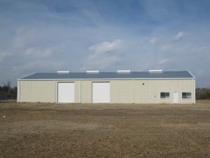
Property Detail
1298 Kenric Rd
Warehouse
AC ADJ AND ON NORTH SIDE OF 1-95 & SR 1589 KENRIC RD
H1
Robeson
AE The base floodplain where base flood elevations are provided. AE Zones are now used on new format FIRMs instead of A1-A30 Zones.
North Carolina
2025
15 AC
2025
Other Market Areas
960801
Lumberton, NC
7,260 SF
0204-01-00906
NEARBY LISTINGS FOR SALE OR LEASE
-
-
View all Lumberton listings for sale on LoopNet.com
DEMOGRAPHICS near 1298 Kenric Rd
1 mile
3 mile
5 mile
2025 Total Population
124
4,242
19,168
2030 Population
132
4,467
20,034
Pop Growth 2025-2030
+ 6.45%
+ 5.30%
+ 4.52%
Average Age
36
39
39
2025 Total Households
47
1,455
7,233
HH Growth 2025-2030
+ 6.38%
+ 6.19%
+ 4.76%
Median Household Inc
$36,666
$38,238
$42,491
Avg Household Size
2.70
2.50
2.50
2025 Avg HH Vehicles
1.00
2.00
2.00
Median Home Value
$89,285
$76,966
$92,856
Median Year Built
1976
1983
1978
Nearby Places
Map Layers
Map Styles
 Street
 Aerial
Layers
 Traffic
 Biking
Places
Listings with unknown addresses are not visible on the map
- Restaurants
- Banks
- Shops
- Fitness
- Groceries
PUBLIC TRANSPORTATION
AIRPORT
Fayetteville Regional/Grannis Field
Drive
Walk
Distance
Fayetteville Regional/Grannis Field
42 min
32.0 mi
Nearby Properties
Address
Land Use
TOTAL SIZE
Lot Size
Zoning
Address
Land Use
TOTAL SIZE
Lot Size
Zoning
384,152 SF
46.63 AC
H1
Address
Land Use
TOTAL SIZE
Lot Size
Zoning
16,128 SF
51.95 AC
M2
Address
Land Use
TOTAL SIZE
Lot Size
Zoning
234,074 SF
63.48 AC
M2
Address
Land Use
TOTAL SIZE
Lot Size
Zoning
10,197 SF
417.66 AC
M1
Address
Land Use
TOTAL SIZE
Lot Size
Zoning
39,628 SF
34.85 AC
M2
Address
Land Use
TOTAL SIZE
Lot Size
Zoning
418,000 SF
31.52 AC
M2
Address
Land Use
TOTAL SIZE
Lot Size
Zoning
62,840 SF
60.96 AC
M2
Address
Land Use
TOTAL SIZE
Lot Size
Zoning
120,000 SF
17.10 AC
M2
Address
Land Use
TOTAL SIZE
Lot Size
Zoning
1,650 SF
26.34 AC
RA
Address
Land Use
TOTAL SIZE
Lot Size
Zoning
297,300 SF
128.80 AC
M2
Address
Land Use
TOTAL SIZE
Lot Size
Zoning
106,046 SF
31.24 AC
RA
Address
Land Use
TOTAL SIZE
Lot Size
Zoning
158,379 SF
17.47 AC
I2
Address
Land Use
TOTAL SIZE
Lot Size
Zoning
1,894 SF
11.48 AC
R3
Address
Land Use
TOTAL SIZE
Lot Size
Zoning
71,260 SF
7.69 AC
B4
Address
Land Use
TOTAL SIZE
Lot Size
Zoning
118,875 SF
7.17 AC
M1
Address
Land Use
TOTAL SIZE
Lot Size
Zoning
173,232 SF
13.83 AC
M2
Address
Land Use
TOTAL SIZE
Lot Size
Zoning
134,250 SF
56.70 AC
M2
Address
Land Use
TOTAL SIZE
Lot Size
Zoning
24,000 SF
14.45 AC
Address
Land Use
TOTAL SIZE
Lot Size
Zoning
16,577 SF
84.06 AC
B4
Address
Land Use
TOTAL SIZE
Lot Size
Zoning
26,508 SF
9.88 AC
Address
Land Use
TOTAL SIZE
Lot Size
Zoning
260,616 SF
10.35 AC
M2
Address
Land Use
TOTAL SIZE
Lot Size
Zoning
9,439 SF
6.40 AC
Address
Land Use
TOTAL SIZE
Lot Size
Zoning
25,056 SF
6.76 AC
Address
Land Use
TOTAL SIZE
Lot Size
Zoning
18,000 SF
31.35 AC
R20
Address
Land Use
TOTAL SIZE
Lot Size
Zoning
24,658 SF
2.98 AC
Address
Land Use
TOTAL SIZE
Lot Size
Zoning
5,675 SF
1.76 AC
B4
Address
Land Use
TOTAL SIZE
Lot Size
Zoning
149,575 SF
28.83 AC
M2
Address
Land Use
TOTAL SIZE
Lot Size
Zoning
20,000 SF
8.85 AC
M2
Address
Land Use
TOTAL SIZE
Lot Size
Zoning
111,915 SF
55.38 AC
I2
Address
Land Use
TOTAL SIZE
Lot Size
Zoning
5,370 SF
2.11 AC
B4
The World's #1 Commercial Real Estate Marketplace
Connect with us
© 2026 CoStar Group
The information above has been obtained from sources believed reliable. While we do not doubt its accuracy we have not verified it and make no guarantee, warranty or representation about it. It is your responsibility to independently confirm its accuracy and completeness. Any projections, opinions, assumptions, or estimates used are for example only and do not represent the current or future performance of the property. The value of this transaction to you depends on tax and other factors which should be evaluated by your tax, financial, and legal advisors. You and your advisors should conduct a careful, independent investigation of the property to determine to your satisfaction the suitability of the property for your needs.