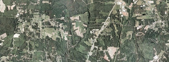
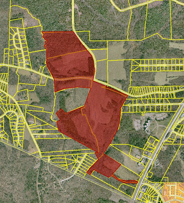
Property Record
1299 Holden Rd, Youngsville, NC 27596

NEARBY LISTINGS FOR SALE OR LEASE
Property Detail
1299 Holden Rd
Raleigh, NC
Moss Tr
037457
ADJ/ACCESS
Vacantlandnec
Franklin
AE
North Carolina
3720184200M
2
2025
80.51 AC
2025
Franklin County
054206
Raleigh/Durham
DEMOGRAPHICS near 1299 Holden Rd
1 Mile
3 Mile
5 Mile
2024 Total Population
1,820
24,722
69,556
2029 Population
2,174
28,448
78,815
Pop Growth 2024-2029
+ 19.45%
+ 15.07%
+ 13.31%
Average Age
41
40
40
2024 Total Households
647
8,938
25,709
HH Growth 2024-2029
+ 19.47%
+ 15.17%
+ 13.28%
Median Household Inc
$111,458
$96,762
$103,191
Avg Household Size
2.80
2.70
2.70
2024 Avg HH Vehicles
2.00
2.00
2.00
Median Home Value
$349,677
$349,137
$367,468
Median Year Built
2003
2001
2005
Nearby Places
Map Layers
Map Styles
 Street
 Aerial
- Restaurants
- Banks
- Shops
- Fitness
- Groceries
PUBLIC TRANSPORTATION
AIRPORT
Raleigh-Durham International
DRIVE
WALK
Distance
Raleigh-Durham International
36 min
24.5 mi
Freight Ports
Virginia Port Authority - Richmond
DRIVE
WALK
Distance
Virginia Port Authority - Richmond
156 min
131.0 mi
Nearby Properties
Address
Land Use
TOTAL SIZE
Lot Size
Zoning
Address
Land Use
TOTAL SIZE
Lot Size
Zoning
442,480 SF
52.02 AC
GR3
Address
Land Use
TOTAL SIZE
Lot Size
Zoning
283,795 SF
31.33 AC
ICD
Address
Land Use
TOTAL SIZE
Lot Size
Zoning
159,584 SF
67.12 AC
FCO GB
Address
Land Use
TOTAL SIZE
Lot Size
Zoning
154,602 SF
40 AC
ICD
Address
Land Use
TOTAL SIZE
Lot Size
Zoning
97,878 SF
26.85 AC
GR5
Address
Land Use
TOTAL SIZE
Lot Size
Zoning
216,580 SF
14.99 AC
FCO GB
Address
Land Use
TOTAL SIZE
Lot Size
Zoning
170,100 SF
15.41 AC
FCO GB
Address
Land Use
TOTAL SIZE
Lot Size
Zoning
106,593 SF
15.32 AC
HB
Address
Land Use
TOTAL SIZE
Lot Size
Zoning
91,233 SF
11.04 AC
GR10
Address
Land Use
TOTAL SIZE
Lot Size
Zoning
20,981 SF
30.74 AC
FCO GB
Address
Land Use
TOTAL SIZE
Lot Size
Zoning
117,680 SF
11.99 AC
GR10
Address
Land Use
TOTAL SIZE
Lot Size
Zoning
364,500 SF
30.25 AC
IND
Address
Land Use
TOTAL SIZE
Lot Size
Zoning
77,343 SF
14.12 AC
GR5
Address
Land Use
TOTAL SIZE
Lot Size
Zoning
117,037 SF
13.88 AC
GR10
Address
Land Use
TOTAL SIZE
Lot Size
Zoning
83,797 SF
11.25 AC
HB
Address
Land Use
TOTAL SIZE
Lot Size
Zoning
105,912 SF
8.44 AC
GR10
Address
Land Use
TOTAL SIZE
Lot Size
Zoning
101,523 SF
2.82 AC
HB
Address
Land Use
TOTAL SIZE
Lot Size
Zoning
50,134 SF
149.08 AC
R-40W
Address
Land Use
TOTAL SIZE
Lot Size
Zoning
92,980 SF
145.72 AC
RMX
Address
Land Use
TOTAL SIZE
Lot Size
Zoning
81,604 SF
17.53 AC
CIVIC
Address
Land Use
TOTAL SIZE
Lot Size
Zoning
65,837 SF
30 AC
M U
Address
Land Use
TOTAL SIZE
Lot Size
Zoning
68,189 SF
8.46 AC
HB
Address
Land Use
TOTAL SIZE
Lot Size
Zoning
1,200 SF
235.84 AC
R-40W
Address
Land Use
TOTAL SIZE
Lot Size
Zoning
148,249 SF
8.45 AC
L I
Address
Land Use
TOTAL SIZE
Lot Size
Zoning
54,023 SF
1.14 AC
GR3
Address
Land Use
TOTAL SIZE
Lot Size
Zoning
28,756 SF
100.63 AC
FCO GB
Address
Land Use
TOTAL SIZE
Lot Size
Zoning
34,176 SF
12.93 AC
CU-1
Address
Land Use
TOTAL SIZE
Lot Size
Zoning
112,694 SF
6.85 AC
M U
Address
Land Use
TOTAL SIZE
Lot Size
Zoning
73,722 SF
23.98 AC
IND
Address
Land Use
TOTAL SIZE
Lot Size
Zoning
880 SF
88.02 AC
MU-2
The World's #1 Commercial Real Estate Marketplace
Connect with us
© 2026 CoStar Group
The information above has been obtained from sources believed reliable. While we do not doubt its accuracy we have not verified it and make no guarantee, warranty or representation about it. It is your responsibility to independently confirm its accuracy and completeness. Any projections, opinions, assumptions, or estimates used are for example only and do not represent the current or future performance of the property. The value of this transaction to you depends on tax and other factors which should be evaluated by your tax, financial, and legal advisors. You and your advisors should conduct a careful, independent investigation of the property to determine to your satisfaction the suitability of the property for your needs.