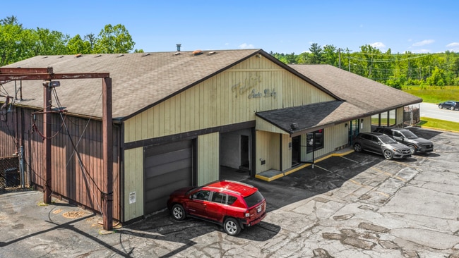
Property Record
12999 Royalton Rd, North Royalton, OH 44133
NEARBY LISTINGS FOR SALE OR LEASE
Property Detail
12999 Royalton Rd
Cleveland-Elyria, OH
Royalton Sec 03
483-17-006
3
Autorepair
Cuyahoga
X
Ohio
39035C0284E
3
2024
0.80 AC
2024
Southwest
175201
Cleveland
8,744 SF
DEMOGRAPHICS near 12999 Royalton Rd
1 Mile
3 Mile
5 Mile
2024 Total Population
3,560
48,891
137,585
2029 Population
3,458
47,570
134,396
Pop Growth 2024-2029
(2.87%)
(2.70%)
(2.32%)
Average Age
40
43
44
2024 Total Households
1,804
20,848
57,243
HH Growth 2024-2029
(3.16%)
(2.92%)
(2.55%)
Median Household Inc
$56,586
$79,912
$80,201
Avg Household Size
1.90
2.30
2.30
2024 Avg HH Vehicles
2.00
2.00
2.00
Median Home Value
$249,574
$240,386
$228,793
Median Year Built
1984
1979
1975
Nearby Places
Map Layers
Map Styles
 Street
 Aerial
- Restaurants
- Banks
- Shops
- Fitness
- Groceries
PUBLIC TRANSPORTATION
AIRPORT
Cleveland-Hopkins International
DRIVE
WALK
Distance
Cleveland-Hopkins International
21 min
11.4 mi
Akron-Canton Regional
DRIVE
WALK
Distance
Akron-Canton Regional
58 min
42.4 mi
SALE & LEASE HISTORY
LISTING DATE
SALE/LEASE

Mar 15, 2024
For Sale
Jun 24, 2025
For Sale
Nearby Properties
Address
Land Use
TOTAL SIZE
Lot Size
Zoning
Address
Land Use
TOTAL SIZE
Lot Size
Zoning
127,666 SF
2.79 AC
Address
Land Use
TOTAL SIZE
Lot Size
Zoning
830,541 SF
51.19 AC
SC
Address
Land Use
TOTAL SIZE
Lot Size
Zoning
184,998 SF
20.43 AC
PF
Address
Land Use
TOTAL SIZE
Lot Size
Zoning
485,330 SF
47.02 AC
TCD
Address
Land Use
TOTAL SIZE
Lot Size
Zoning
154,702 SF
23.37 AC
PF
Address
Land Use
TOTAL SIZE
Lot Size
Zoning
168,729 SF
11.56 AC
GB
Address
Land Use
TOTAL SIZE
Lot Size
Zoning
244,717 SF
23.97 AC
RMF-1
Address
Land Use
TOTAL SIZE
Lot Size
Zoning
229,190 SF
25.06 AC
GB
Address
Land Use
TOTAL SIZE
Lot Size
Zoning
62,681 SF
5.48 AC
OB
Address
Land Use
TOTAL SIZE
Lot Size
Zoning
127,666 SF
9.53 AC
Address
Land Use
TOTAL SIZE
Lot Size
Zoning
309,231 SF
34.28 AC
Address
Land Use
TOTAL SIZE
Lot Size
Zoning
149,328 SF
14.78 AC
RM-D
Address
Land Use
TOTAL SIZE
Lot Size
Zoning
143,074 SF
25.34 AC
PDA-2
Address
Land Use
TOTAL SIZE
Lot Size
Zoning
288,114 SF
27.52 AC
GB
Address
Land Use
TOTAL SIZE
Lot Size
Zoning
17,682 SF
36.78 AC
MF1
Address
Land Use
TOTAL SIZE
Lot Size
Zoning
39,848 SF
48 AC
RM-D
Address
Land Use
TOTAL SIZE
Lot Size
Zoning
230,291 SF
17.35 AC
Address
Land Use
TOTAL SIZE
Lot Size
Zoning
118,375 SF
24.17 AC
RM-D
Address
Land Use
TOTAL SIZE
Lot Size
Zoning
614 SF
19.13 AC
RRZ
Address
Land Use
TOTAL SIZE
Lot Size
Zoning
139,914 SF
17.98 AC
MS
Address
Land Use
TOTAL SIZE
Lot Size
Zoning
124,195 SF
54.96 AC
PF
Address
Land Use
TOTAL SIZE
Lot Size
Zoning
149,522 SF
19.09 AC
PF
Address
Land Use
TOTAL SIZE
Lot Size
Zoning
34,005 SF
514.86 AC
PF
Address
Land Use
TOTAL SIZE
Lot Size
Zoning
73,920 SF
22.53 AC
RM-D
Address
Land Use
TOTAL SIZE
Lot Size
Zoning
275,274 SF
16.91 AC
RMF-1
Address
Land Use
TOTAL SIZE
Lot Size
Zoning
10,560 SF
22.12 AC
RM-D
Address
Land Use
TOTAL SIZE
Lot Size
Zoning
10,560 SF
19.12 AC
RM-D
Address
Land Use
TOTAL SIZE
Lot Size
Zoning
74,988 SF
19.16 AC
RM-D
Address
Land Use
TOTAL SIZE
Lot Size
Zoning
149,184 SF
14.09 AC
PDA-2
Address
Land Use
TOTAL SIZE
Lot Size
Zoning
242.53 AC
PF
The World's #1 Commercial Real Estate Marketplace
Connect with us
© 2026 CoStar Group
The information above has been obtained from sources believed reliable. While we do not doubt its accuracy we have not verified it and make no guarantee, warranty or representation about it. It is your responsibility to independently confirm its accuracy and completeness. Any projections, opinions, assumptions, or estimates used are for example only and do not represent the current or future performance of the property. The value of this transaction to you depends on tax and other factors which should be evaluated by your tax, financial, and legal advisors. You and your advisors should conduct a careful, independent investigation of the property to determine to your satisfaction the suitability of the property for your needs.