Property Record
12Th-H N Street Ext, West Columbia, SC 29172
NEARBY LISTINGS FOR SALE OR LEASE
Property Detail
12Th-H N Street Ext
Columbia, SC
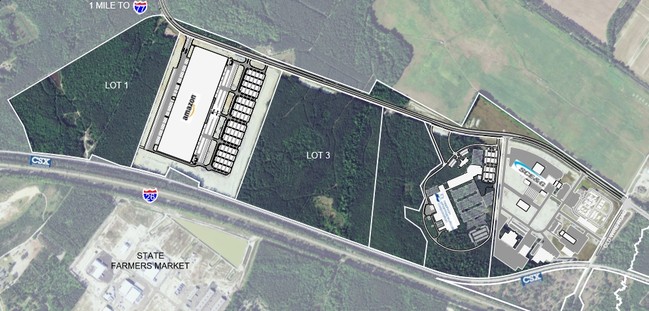
SAXE GOTHA INDUSTRIAL PARK PH 1
008097-01-001
Lexington
Countyproperty
South Carolina
AE
1
45063C0291J
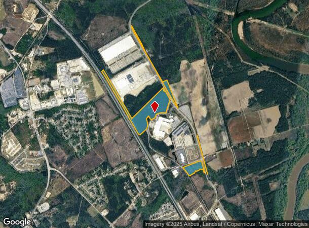
66.96 AC
0
Cayce/West Columbia
2024
Columbia
020707
DEMOGRAPHICS near 12Th-H N Street Ext
1 Mile
3 Mile
5 Mile
2024 Total Population
1,157
7,105
33,774
2029 Population
1,285
7,818
36,678
Pop Growth 2024-2029
+ 11.06%
+ 10.04%
+ 8.60%
Average Age
37
39
38
2024 Total Households
429
2,889
14,390
HH Growth 2024-2029
+ 11.19%
+ 10.11%
+ 8.78%
Median Household Inc
$54,545
$57,012
$50,889
Avg Household Size
2.50
2.40
2.30
2024 Avg HH Vehicles
2.00
2.00
2.00
Median Home Value
$78,488
$139,929
$139,347
Median Year Built
1984
1986
1984
Nearby Places
Map Layers
Map Styles
 Street
 Aerial
- Restaurants
- Banks
- Shops
- Fitness
- Groceries
PUBLIC TRANSPORTATION
COMMUTER RAIL
Columbia Amtrak Station (Silver Star - Amtrak)
DRIVE
WALK
Distance
Columbia Amtrak Station (Silver Star - Amtrak)
17 min
9.0 mi
AIRPORT
Columbia Metro
DRIVE
WALK
Distance
Columbia Metro
23 min
10.6 mi
Freight Ports
North Charleston Terminal
DRIVE
WALK
Distance
North Charleston Terminal
111 min
96.6 mi
SALE & LEASE HISTORY
LISTING DATE
SALE/LEASE

Sep 24, 2016
For Sale
Aug 16, 2017
For Sale
Nearby Properties
Address
Land Use
TOTAL SIZE
Lot Size
Zoning
Address
Land Use
TOTAL SIZE
Lot Size
Zoning
56.30 AC
Address
Land Use
TOTAL SIZE
Lot Size
Zoning
1,253,820 SF
87.15 AC
Address
Land Use
TOTAL SIZE
Lot Size
Zoning
960.50 AC
Address
Land Use
TOTAL SIZE
Lot Size
Zoning
466,400 SF
52.42 AC
ID
Address
Land Use
TOTAL SIZE
Lot Size
Zoning
4,586 SF
19.15 AC
Address
Land Use
TOTAL SIZE
Lot Size
Zoning
186,528 SF
36 AC
Address
Land Use
TOTAL SIZE
Lot Size
Zoning
180,000 SF
27.57 AC
ID
Address
Land Use
TOTAL SIZE
Lot Size
Zoning
181,440 SF
10.69 AC
ID
Address
Land Use
TOTAL SIZE
Lot Size
Zoning
9,800 SF
13.52 AC
ID
Address
Land Use
TOTAL SIZE
Lot Size
Zoning
200,000 SF
10.58 AC
ID
Address
Land Use
TOTAL SIZE
Lot Size
Zoning
61,012 SF
5.34 AC
Address
Land Use
TOTAL SIZE
Lot Size
Zoning
200,000 SF
9.66 AC
ID
Address
Land Use
TOTAL SIZE
Lot Size
Zoning
51,100 SF
9.98 AC
RU
Address
Land Use
TOTAL SIZE
Lot Size
Zoning
180,000 SF
12.48 AC
ID
Address
Land Use
TOTAL SIZE
Lot Size
Zoning
36.30 AC
Address
Land Use
TOTAL SIZE
Lot Size
Zoning
7.60 AC
Address
Land Use
TOTAL SIZE
Lot Size
Zoning
35.70 AC
Address
Land Use
TOTAL SIZE
Lot Size
Zoning
215,770 SF
24.51 AC
Address
Land Use
TOTAL SIZE
Lot Size
Zoning
50,400 SF
11 AC
ID
Address
Land Use
TOTAL SIZE
Lot Size
Zoning
92.08 AC
Address
Land Use
TOTAL SIZE
Lot Size
Zoning
104,000 SF
18.53 AC
Address
Land Use
TOTAL SIZE
Lot Size
Zoning
120,000 SF
18.44 AC
ID
Address
Land Use
TOTAL SIZE
Lot Size
Zoning
53.82 AC
Address
Land Use
TOTAL SIZE
Lot Size
Zoning
28.17 AC
Address
Land Use
TOTAL SIZE
Lot Size
Zoning
50,000 SF
6.89 AC
ID
Address
Land Use
TOTAL SIZE
Lot Size
Zoning
67,824 SF
17.27 AC
ID
Address
Land Use
TOTAL SIZE
Lot Size
Zoning
9,444 SF
13.72 AC
M1
Address
Land Use
TOTAL SIZE
Lot Size
Zoning
84.65 AC
Address
Land Use
TOTAL SIZE
Lot Size
Zoning
28,210 SF
9.54 AC
The World's #1 Commercial Real Estate Marketplace
Connect with us
© 2026 CoStar Group
The information above has been obtained from sources believed reliable. While we do not doubt its accuracy we have not verified it and make no guarantee, warranty or representation about it. It is your responsibility to independently confirm its accuracy and completeness. Any projections, opinions, assumptions, or estimates used are for example only and do not represent the current or future performance of the property. The value of this transaction to you depends on tax and other factors which should be evaluated by your tax, financial, and legal advisors. You and your advisors should conduct a careful, independent investigation of the property to determine to your satisfaction the suitability of the property for your needs.