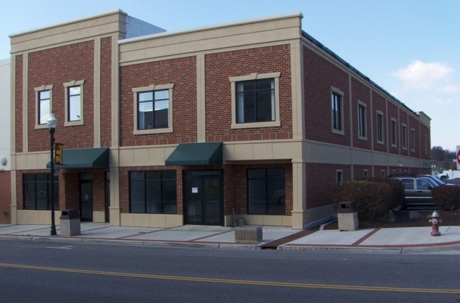
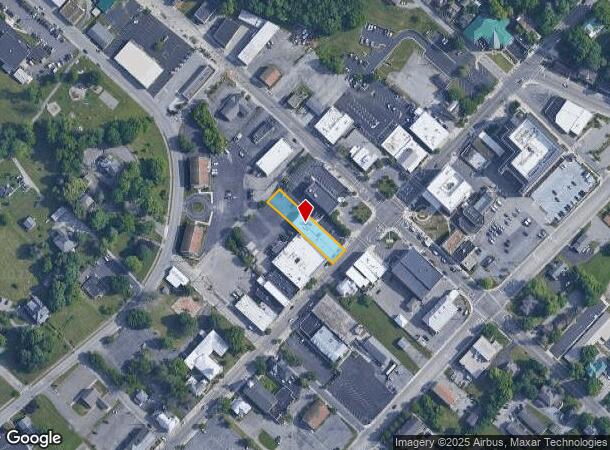
Property Record
17 W Main St, Christiansburg, VA 24073
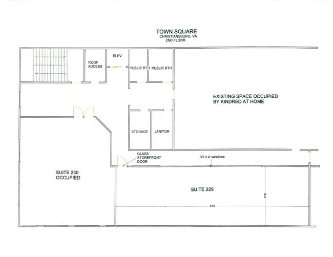
Current Lease Availabilities
NEARBY LISTINGS FOR SALE OR LEASE
Property Detail
17 W Main St
013533
N/S W MAIN ST SHERMANS STORE
Commercialnec
Montgomery
X
Virginia
51121C0143C
0.35 AC
2025
Blacksburg & Wytheville
2025
Other Market Areas
021101
Blacksburg-Christiansburg-Radford, VA
5,180 SF
DEMOGRAPHICS near 17 W Main St
1 Mile
3 Mile
5 Mile
2024 Total Population
7,785
22,468
34,420
2029 Population
7,665
22,155
34,013
Pop Growth 2024-2029
(1.54%)
(1.39%)
(1.18%)
Average Age
41
40
41
2024 Total Households
3,457
9,627
14,702
HH Growth 2024-2029
(1.59%)
(1.40%)
(1.18%)
Median Household Inc
$49,999
$65,293
$62,767
Avg Household Size
2.20
2.30
2.30
2024 Avg HH Vehicles
2.00
2.00
2.00
Median Home Value
$226,289
$232,446
$237,051
Median Year Built
1976
1990
1990
Nearby Places
- Restaurants
- Banks
- Shops
- Fitness
- Groceries
PUBLIC TRANSPORTATION
AIRPORT
Roanoke/Blacksburg Regional (Woodrum Field)
DRIVE
WALK
Distance
Roanoke/Blacksburg Regional (Woodrum Field)
48 min
35.4 mi
Freight Ports
Virginia Port Authority - Richmond
DRIVE
WALK
Distance
Virginia Port Authority - Richmond
250 min
219.2 mi
Nearby Properties
Address
Land Use
TOTAL SIZE
Lot Size
Zoning
Address
Land Use
TOTAL SIZE
Lot Size
Zoning
Address
Land Use
TOTAL SIZE
Lot Size
Zoning
190,465 SF
30.37 AC
R1
Address
Land Use
TOTAL SIZE
Lot Size
Zoning
33.70 AC
A1
Address
Land Use
TOTAL SIZE
Lot Size
Zoning
151,388 SF
18.29 AC
B3
Address
Land Use
TOTAL SIZE
Lot Size
Zoning
315,000 SF
46.09 AC
I2
Address
Land Use
TOTAL SIZE
Lot Size
Zoning
151,450 SF
13.88 AC
B3
Address
Land Use
TOTAL SIZE
Lot Size
Zoning
16.65 AC
I2
Address
Land Use
TOTAL SIZE
Lot Size
Zoning
61,682 SF
21.65 AC
A
Address
Land Use
TOTAL SIZE
Lot Size
Zoning
538,247 SF
54.60 AC
B3
Address
Land Use
TOTAL SIZE
Lot Size
Zoning
200,004 SF
23.11 AC
B3
Address
Land Use
TOTAL SIZE
Lot Size
Zoning
147,552 SF
4.54 AC
I2
Address
Land Use
TOTAL SIZE
Lot Size
Zoning
3.86 AC
Address
Land Use
TOTAL SIZE
Lot Size
Zoning
124,503 SF
11.30 AC
B3
Address
Land Use
TOTAL SIZE
Lot Size
Zoning
49,525 SF
11.07 AC
B3
Address
Land Use
TOTAL SIZE
Lot Size
Zoning
108,510 SF
11.89 AC
B3
Address
Land Use
TOTAL SIZE
Lot Size
Zoning
7.95 AC
A
Address
Land Use
TOTAL SIZE
Lot Size
Zoning
281,082 SF
33.56 AC
I2
Address
Land Use
TOTAL SIZE
Lot Size
Zoning
99,595 SF
11.92 AC
B3
Address
Land Use
TOTAL SIZE
Lot Size
Zoning
128,416 SF
17.24 AC
B3
Address
Land Use
TOTAL SIZE
Lot Size
Zoning
46.46 AC
GB
Address
Land Use
TOTAL SIZE
Lot Size
Zoning
61,328 SF
2.33 AC
B3
Address
Land Use
TOTAL SIZE
Lot Size
Zoning
7,800 SF
11.47 AC
B3
Address
Land Use
TOTAL SIZE
Lot Size
Zoning
52,475 SF
19.11 AC
B3
Address
Land Use
TOTAL SIZE
Lot Size
Zoning
Address
Land Use
TOTAL SIZE
Lot Size
Zoning
40,363 SF
12.30 AC
B3
Address
Land Use
TOTAL SIZE
Lot Size
Zoning
133,000 SF
9.67 AC
I2
Address
Land Use
TOTAL SIZE
Lot Size
Zoning
43,200 SF
2.30 AC
B3
Address
Land Use
TOTAL SIZE
Lot Size
Zoning
1,712 SF
131.68 AC
A1
Address
Land Use
TOTAL SIZE
Lot Size
Zoning
95,224 SF
7.96 AC
B3
Address
Land Use
TOTAL SIZE
Lot Size
Zoning
50,627 SF
3.04 AC
B3
The World's #1 Commercial Real Estate Marketplace
Connect with us
© 2025 CoStar Group
The information above has been obtained from sources believed reliable. While we do not doubt its accuracy we have not verified it and make no guarantee, warranty or representation about it. It is your responsibility to independently confirm its accuracy and completeness. Any projections, opinions, assumptions, or estimates used are for example only and do not represent the current or future performance of the property. The value of this transaction to you depends on tax and other factors which should be evaluated by your tax, financial, and legal advisors. You and your advisors should conduct a careful, independent investigation of the property to determine to your satisfaction the suitability of the property for your needs.