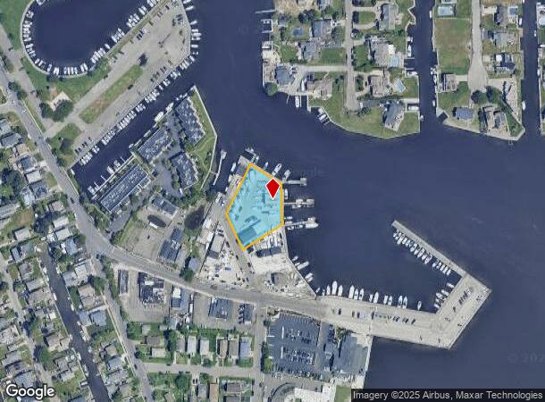
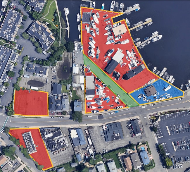
Property Record
13 Post Pl, Babylon, NY 11702
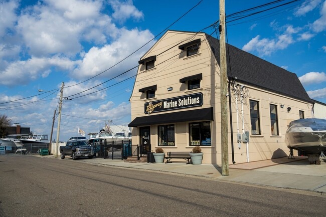

This Property Is For Sale
NEARBY LISTINGS FOR SALE OR LEASE
Property Detail
13 Post Pl
Nassau County-Suffolk County, NY
Village Of Babtlon
0102-019-00-03-00-023-001
FILED MAP 529 LTS 6-9 INC. & S PT 10
Marinafacility
Suffolk
AE
New York
36103C0862H
23
2024
0.73 AC
2024
Southwestern Suffolk
124602
Long Island (New York)
DEMOGRAPHICS near 13 Post Pl
1 mile
3 mile
5 mile
2024 Total Population
7,252
74,982
211,381
2029 Population
7,182
73,647
206,665
Pop Growth 2024-2029
(0.97%)
(1.78%)
(2.23%)
Average Age
43
42
41
2024 Total Households
2,577
25,990
69,404
HH Growth 2024-2029
(1.16%)
(2.04%)
(2.42%)
Median Household Inc
$134,191
$119,871
$112,748
Avg Household Size
2.70
2.80
2.90
2024 Avg HH Vehicles
2.00
2.00
2.00
Median Home Value
$762,686
$486,449
$453,835
Median Year Built
1955
1960
1960
Nearby Places
Map Layers
Map Styles
 Street
 Aerial
Transit
 Traffic
 Biking
Places
Listings with unknown addresses are not visible on the map
- Restaurants
- Banks
- Shops
- Fitness
- Groceries
PUBLIC TRANSPORTATION
COMMUTER RAIL
Babylon Station (Babylon Branch - Long Island Rail Road, Montauk Branch - Long Island Rail Road)
Drive
Walk
Distance
Babylon Station (Babylon Branch - Long Island Rail Road, Montauk Branch - Long Island Rail Road)
5 min
1.4 mi
Lindenhurst Station (Babylon Branch - Long Island Rail Road)
Drive
Walk
Distance
Lindenhurst Station (Babylon Branch - Long Island Rail Road)
9 min
3.7 mi
AIRPORT
Long Island MacArthur
Drive
Walk
Distance
Long Island MacArthur
28 min
17.2 mi
John F Kennedy International
Drive
Walk
Distance
John F Kennedy International
45 min
29.7 mi
LaGuardia
Drive
Walk
Distance
LaGuardia
55 min
36.6 mi
Freight Ports
NY - Red Hook Container Terminal
Drive
Walk
Distance
NY - Red Hook Container Terminal
66 min
41.1 mi
Nearby Properties
Address
Land Use
TOTAL SIZE
Lot Size
Zoning
Address
Land Use
TOTAL SIZE
Lot Size
Zoning
48.97 AC
GSC
Address
Land Use
TOTAL SIZE
Lot Size
Zoning
37,072 SF
14.68 AC
R60
Address
Land Use
TOTAL SIZE
Lot Size
Zoning
256 SF
24.20 AC
GSC
Address
Land Use
TOTAL SIZE
Lot Size
Zoning
4,172 SF
0.88 AC
R60
Address
Land Use
TOTAL SIZE
Lot Size
Zoning
20 AC
A
Address
Land Use
TOTAL SIZE
Lot Size
Zoning
10.07 AC
Address
Land Use
TOTAL SIZE
Lot Size
Zoning
5,040 SF
0.70 AC
VILLA
Address
Land Use
TOTAL SIZE
Lot Size
Zoning
2,418 SF
0.15 AC
VILLA
Address
Land Use
TOTAL SIZE
Lot Size
Zoning
20.50 AC
B
Address
Land Use
TOTAL SIZE
Lot Size
Zoning
231.30 AC
AAA
Address
Land Use
TOTAL SIZE
Lot Size
Zoning
20.10 AC
A
Address
Land Use
TOTAL SIZE
Lot Size
Zoning
2,140 SF
0.19 AC
VILLA
Address
Land Use
TOTAL SIZE
Lot Size
Zoning
2,416 SF
0.28 AC
VILLA
Address
Land Use
TOTAL SIZE
Lot Size
Zoning
4,290 SF
1.50 AC
VILLA
Address
Land Use
TOTAL SIZE
Lot Size
Zoning
2,627 SF
0.36 AC
VILLA
Address
Land Use
TOTAL SIZE
Lot Size
Zoning
3,917 SF
0.85 AC
CR200
Address
Land Use
TOTAL SIZE
Lot Size
Zoning
9,309 SF
1.02 AC
R40
Address
Land Use
TOTAL SIZE
Lot Size
Zoning
18.70 AC
A
Address
Land Use
TOTAL SIZE
Lot Size
Zoning
6.66 AC
A
Address
Land Use
TOTAL SIZE
Lot Size
Zoning
3,778 SF
0.93 AC
R40
Address
Land Use
TOTAL SIZE
Lot Size
Zoning
2,969 SF
2.50 AC
R40
Address
Land Use
TOTAL SIZE
Lot Size
Zoning
9.80 AC
AA
Address
Land Use
TOTAL SIZE
Lot Size
Zoning
14.60 AC
A
Address
Land Use
TOTAL SIZE
Lot Size
Zoning
9.70 AC
B
Address
Land Use
TOTAL SIZE
Lot Size
Zoning
19.40 AC
IND1
Address
Land Use
TOTAL SIZE
Lot Size
Zoning
3,489 SF
0.41 AC
CR40
Address
Land Use
TOTAL SIZE
Lot Size
Zoning
11 AC
B
Address
Land Use
TOTAL SIZE
Lot Size
Zoning
4,246 SF
1.87 AC
CR80
Address
Land Use
TOTAL SIZE
Lot Size
Zoning
3,728 SF
3 AC
AA
Address
Land Use
TOTAL SIZE
Lot Size
Zoning
7.50 AC
B
The World's #1 Commercial Real Estate Marketplace
Connect with us
© 2026 CoStar Group
The information above has been obtained from sources believed reliable. While we do not doubt its accuracy we have not verified it and make no guarantee, warranty or representation about it. It is your responsibility to independently confirm its accuracy and completeness. Any projections, opinions, assumptions, or estimates used are for example only and do not represent the current or future performance of the property. The value of this transaction to you depends on tax and other factors which should be evaluated by your tax, financial, and legal advisors. You and your advisors should conduct a careful, independent investigation of the property to determine to your satisfaction the suitability of the property for your needs.