Property Record
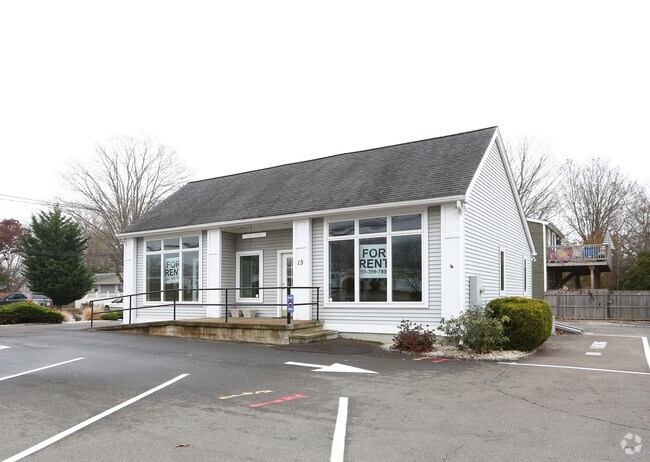
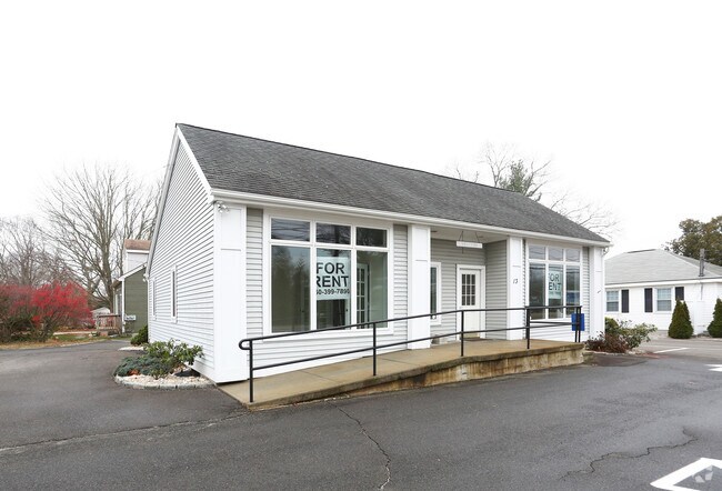
13 Boston Post Rd, Westbrook, CT 06498

Property Detail
13 Boston Post Rd
WBRO-000187-000000-000126
Lower Ct River Vly
Commercialofficeresidentialmixeduse
Connecticut
NCD
126
B and X Area of moderate flood hazard, usually the area between the limits of the 100-year and 500-year floods.
0.32 AC
2025
SW Midlsx/Old Saybrk/Rt 9
2025
Hartford
680102
Hartford-West Hartford-East Hartford, CT
NEARBY LISTINGS FOR SALE OR LEASE
DEMOGRAPHICS near 13 Boston Post Rd
1 mile
3 mile
5 mile
2025 Total Population
2,071
13,706
28,099
2030 Population
2,178
14,180
29,037
Pop Growth 2025-2030
+ 5.17%
+ 3.46%
+ 3.34%
Average Age
51
48
48
2025 Total Households
1,025
6,231
12,252
HH Growth 2025-2030
+ 5.27%
+ 3.82%
+ 3.70%
Median Household Inc
$97,714
$98,967
$104,686
Avg Household Size
2.00
2.10
2.20
2025 Avg HH Vehicles
2.00
2.00
2.00
Median Home Value
$551,259
$433,581
$453,329
Median Year Built
1962
1965
1969
Nearby Places
Map Layers
Map Styles
 Street
 Aerial
Transit
 Traffic
 Biking
Places
Listings with unknown addresses are not visible on the map
- Restaurants
- Banks
- Shops
- Fitness
- Groceries
PUBLIC TRANSPORTATION
COMMUTER RAIL
Clinton (Shore Line East - Shore Line East)
Drive
Walk
Distance
Clinton (Shore Line East - Shore Line East)
7 min
2.4 mi
Westbrook (Shore Line East - Shore Line East)
Drive
Walk
Distance
Westbrook (Shore Line East - Shore Line East)
8 min
2.8 mi
Nearby Properties
Address
Land Use
TOTAL SIZE
Lot Size
Zoning
Address
Land Use
TOTAL SIZE
Lot Size
Zoning
47.11 AC
Address
Land Use
TOTAL SIZE
Lot Size
Zoning
138,909 SF
41.60 AC
R-20
Address
Land Use
TOTAL SIZE
Lot Size
Zoning
91,300 SF
8.03 AC
TIC
Address
Land Use
TOTAL SIZE
Lot Size
Zoning
159,832 SF
110.10 AC
RR
Address
Land Use
TOTAL SIZE
Lot Size
Zoning
14.87 AC
NCD
Address
Land Use
TOTAL SIZE
Lot Size
Zoning
322.64 AC
RR/MDR
Address
Land Use
TOTAL SIZE
Lot Size
Zoning
87,717 SF
12 AC
Address
Land Use
TOTAL SIZE
Lot Size
Zoning
624 SF
43.91 AC
CB
Address
Land Use
TOTAL SIZE
Lot Size
Zoning
98,963 SF
49.97 AC
Address
Land Use
TOTAL SIZE
Lot Size
Zoning
46.69 AC
MDR
Address
Land Use
TOTAL SIZE
Lot Size
Zoning
81,335 SF
8.64 AC
B-4
Address
Land Use
TOTAL SIZE
Lot Size
Zoning
96,949 SF
11.52 AC
Address
Land Use
TOTAL SIZE
Lot Size
Zoning
54,375 SF
7.01 AC
Address
Land Use
TOTAL SIZE
Lot Size
Zoning
15,446 SF
7.56 AC
B-2
Address
Land Use
TOTAL SIZE
Lot Size
Zoning
46,536 SF
3.62 AC
Address
Land Use
TOTAL SIZE
Lot Size
Zoning
35.50 AC
CB
Address
Land Use
TOTAL SIZE
Lot Size
Zoning
22,984 SF
6.58 AC
MDR
Address
Land Use
TOTAL SIZE
Lot Size
Zoning
56,608 SF
1.27 AC
I-1
Address
Land Use
TOTAL SIZE
Lot Size
Zoning
5.56 AC
Address
Land Use
TOTAL SIZE
Lot Size
Zoning
85,800 SF
11.56 AC
LI/RR
Address
Land Use
TOTAL SIZE
Lot Size
Zoning
11.70 AC
NCD
Address
Land Use
TOTAL SIZE
Lot Size
Zoning
24,632 SF
4.48 AC
LI
Address
Land Use
TOTAL SIZE
Lot Size
Zoning
9.32 AC
M-1
Address
Land Use
TOTAL SIZE
Lot Size
Zoning
32,752 SF
6.73 AC
TIC
Address
Land Use
TOTAL SIZE
Lot Size
Zoning
25,080 SF
2.77 AC
B-3
Address
Land Use
TOTAL SIZE
Lot Size
Zoning
13,448 SF
2.14 AC
B-4
Address
Land Use
TOTAL SIZE
Lot Size
Zoning
32,621 SF
3 AC
TIC
Address
Land Use
TOTAL SIZE
Lot Size
Zoning
912 SF
6.63 AC
HDR/MD
Address
Land Use
TOTAL SIZE
Lot Size
Zoning
2.86 AC
R-10
Address
Land Use
TOTAL SIZE
Lot Size
Zoning
2.23 AC
MDR
The World's #1 Commercial Real Estate Marketplace
Connect with us
© 2026 CoStar Group
The information above has been obtained from sources believed reliable. While we do not doubt its accuracy we have not verified it and make no guarantee, warranty or representation about it. It is your responsibility to independently confirm its accuracy and completeness. Any projections, opinions, assumptions, or estimates used are for example only and do not represent the current or future performance of the property. The value of this transaction to you depends on tax and other factors which should be evaluated by your tax, financial, and legal advisors. You and your advisors should conduct a careful, independent investigation of the property to determine to your satisfaction the suitability of the property for your needs.