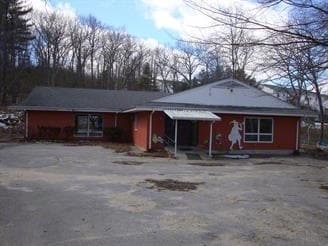
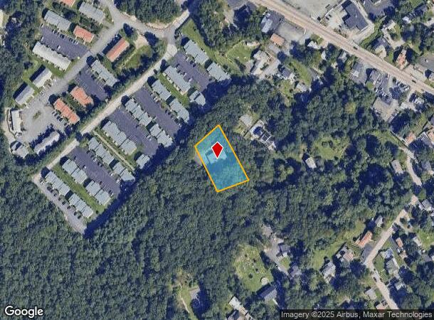
Property Record
13 Hebdeen St, Johnston, RI 02919
NEARBY LISTINGS FOR SALE OR LEASE
Property Detail
13 Hebdeen St
JOHN-000049-000000-000082
Providence
Commercialbuilding
Rhode Island
X
82
44007C0282G
0.64 AC
2025
Johnston
2025
Providence
012300
Providence-Warwick, RI-MA
4,040 SF
DEMOGRAPHICS near 13 Hebdeen St
1 mile
3 mile
5 mile
2024 Total Population
7,977
62,608
204,668
2029 Population
7,985
62,624
203,366
Pop Growth 2024-2029
+ 0.10%
+ 0.03%
(0.64%)
Average Age
43
43
39
2024 Total Households
3,528
26,392
79,849
HH Growth 2024-2029
(0.06%)
(0.06%)
(0.65%)
Median Household Inc
$88,821
$79,200
$69,312
Avg Household Size
2.30
2.30
2.40
2024 Avg HH Vehicles
2.00
2.00
2.00
Median Home Value
$320,904
$316,801
$299,288
Median Year Built
1964
1969
1959
Nearby Places
Map Layers
Map Styles
 Street
 Aerial
Transit
 Traffic
 Biking
Places
Listings with unknown addresses are not visible on the map
- Restaurants
- Banks
- Shops
- Fitness
- Groceries
PUBLIC TRANSPORTATION
COMMUTER RAIL
Providence (Providence/Stoughton Line - Massachusetts Bay Transportation Authority Commuter Rail (Purple Line))
Drive
Walk
Distance
Providence (Providence/Stoughton Line - Massachusetts Bay Transportation Authority Commuter Rail (Purple Line))
11 min
5.8 mi
Drive
Walk
Distance
11 min
6.3 mi
AIRPORT
Rhode Island Tf Green International
Drive
Walk
Distance
Rhode Island Tf Green International
25 min
15.9 mi
Worcester Regional
Drive
Walk
Distance
Worcester Regional
57 min
42.5 mi
Freight Ports
Port of Davisville, RI
Drive
Walk
Distance
Port of Davisville, RI
37 min
25.2 mi
Nearby Properties
Address
Land Use
TOTAL SIZE
Lot Size
Zoning
Address
Land Use
TOTAL SIZE
Lot Size
Zoning
254,488 SF
17.50 AC
IS
Address
Land Use
TOTAL SIZE
Lot Size
Zoning
89.07 AC
PD
Address
Land Use
TOTAL SIZE
Lot Size
Zoning
28.92 AC
PS
Address
Land Use
TOTAL SIZE
Lot Size
Zoning
53.18 AC
C
Address
Land Use
TOTAL SIZE
Lot Size
Zoning
123.25 AC
R40
Address
Land Use
TOTAL SIZE
Lot Size
Zoning
301,035 SF
21.69 AC
15
Address
Land Use
TOTAL SIZE
Lot Size
Zoning
1,792 SF
28.46 AC
Address
Land Use
TOTAL SIZE
Lot Size
Zoning
159,028 SF
12.09 AC
RG
Address
Land Use
TOTAL SIZE
Lot Size
Zoning
288,736 SF
11.99 AC
RG
Address
Land Use
TOTAL SIZE
Lot Size
Zoning
30.14 AC
R40
Address
Land Use
TOTAL SIZE
Lot Size
Zoning
11.43 AC
I-2
Address
Land Use
TOTAL SIZE
Lot Size
Zoning
63.33 AC
OS
Address
Land Use
TOTAL SIZE
Lot Size
Zoning
8.96 AC
I-2
Address
Land Use
TOTAL SIZE
Lot Size
Zoning
166,368 SF
10.74 AC
R20
Address
Land Use
TOTAL SIZE
Lot Size
Zoning
237,440 SF
19.31 AC
IS
Address
Land Use
TOTAL SIZE
Lot Size
Zoning
175,231 SF
9.37 AC
Address
Land Use
TOTAL SIZE
Lot Size
Zoning
21.74 AC
I-2
Address
Land Use
TOTAL SIZE
Lot Size
Zoning
Address
Land Use
TOTAL SIZE
Lot Size
Zoning
69.31 AC
OS
Address
Land Use
TOTAL SIZE
Lot Size
Zoning
185,010 SF
7.75 AC
MG
Address
Land Use
TOTAL SIZE
Lot Size
Zoning
137,704 SF
11.57 AC
Address
Land Use
TOTAL SIZE
Lot Size
Zoning
48.58 AC
I-2
Address
Land Use
TOTAL SIZE
Lot Size
Zoning
1 AC
R40
Address
Land Use
TOTAL SIZE
Lot Size
Zoning
56,451 SF
5 AC
C
Address
Land Use
TOTAL SIZE
Lot Size
Zoning
22,868 SF
12.22 AC
R20
Address
Land Use
TOTAL SIZE
Lot Size
Zoning
135,476 SF
10.30 AC
MG
Address
Land Use
TOTAL SIZE
Lot Size
Zoning
124,397 SF
13.66 AC
C
Address
Land Use
TOTAL SIZE
Lot Size
Zoning
89,788 SF
11.25 AC
R20
Address
Land Use
TOTAL SIZE
Lot Size
Zoning
18.05 AC
I-2
Address
Land Use
TOTAL SIZE
Lot Size
Zoning
114,795 SF
1.93 AC
BL
The World's #1 Commercial Real Estate Marketplace
Connect with us
© 2026 CoStar Group
The information above has been obtained from sources believed reliable. While we do not doubt its accuracy we have not verified it and make no guarantee, warranty or representation about it. It is your responsibility to independently confirm its accuracy and completeness. Any projections, opinions, assumptions, or estimates used are for example only and do not represent the current or future performance of the property. The value of this transaction to you depends on tax and other factors which should be evaluated by your tax, financial, and legal advisors. You and your advisors should conduct a careful, independent investigation of the property to determine to your satisfaction the suitability of the property for your needs.