Property Record
13 Main St, Argyle, NY 12809

Save to a Folder
{{folder.Name}}
{{folder.ListingIds.length}} Properties
{{folder.ListingIds.length}} Property
Create a New Folder
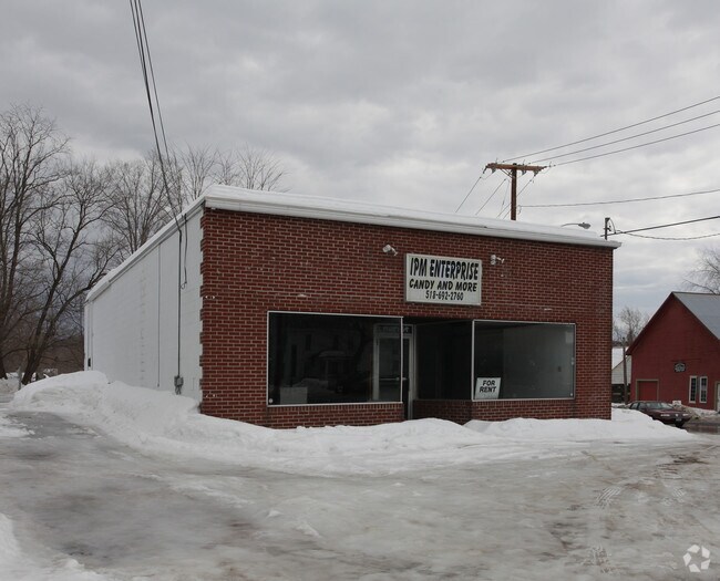
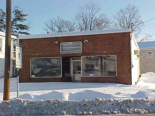
Property Detail
13 Main St
Glens Falls, NY
BLOCK
533401-237-005-0004-046-000-0000
WASHINGTON
Storesoffices
New York
COM01
46.000
2025
0.18 AC
2025
Washington County
087000
Albany/Schenectady/Troy
2,010 SF
NEARBY LISTINGS FOR SALE OR LEASE
-
-
View all Argyle listings for sale on LoopNet.com
DEMOGRAPHICS near 13 Main St
1 mile
3 mile
5 mile
2025 Total Population
2,101
3,728
7,482
2030 Population
2,081
3,685
7,395
Pop Growth 2025-2030
(0.95%)
(1.15%)
(1.16%)
Average Age
43
44
43
2025 Total Households
885
1,556
3,120
HH Growth 2025-2030
(1.24%)
(1.35%)
(1.25%)
Median Household Inc
$79,011
$80,617
$76,087
Avg Household Size
2.40
2.40
2.40
2025 Avg HH Vehicles
2.00
2.00
2.00
Median Home Value
$239,935
$241,472
$235,148
Median Year Built
1947
1948
1948
Nearby Places
Map Layers
Map Styles
 Street
 Aerial
Layers
 Traffic
 Biking
Places
Listings with unknown addresses are not visible on the map
- Restaurants
- Banks
- Shops
- Fitness
- Groceries
PUBLIC TRANSPORTATION
AIRPORT
Albany International
Drive
Walk
Distance
Albany International
57 min
35.6 mi
Freight Ports
Albany, NY Port
Drive
Walk
Distance
Albany, NY Port
65 min
39.5 mi
Nearby Properties
Address
Land Use
TOTAL SIZE
Lot Size
Zoning
Address
Land Use
TOTAL SIZE
Lot Size
Zoning
36,583 SF
30.10 AC
MDR
Address
Land Use
TOTAL SIZE
Lot Size
Zoning
768 SF
45.40 AC
HMU
Address
Land Use
TOTAL SIZE
Lot Size
Zoning
4,716 SF
43.66 AC
Address
Land Use
TOTAL SIZE
Lot Size
Zoning
10,000 SF
42.26 AC
Address
Land Use
TOTAL SIZE
Lot Size
Zoning
176,860 SF
30.69 AC
I
Address
Land Use
TOTAL SIZE
Lot Size
Zoning
23,516 SF
9.80 AC
C
Address
Land Use
TOTAL SIZE
Lot Size
Zoning
63,072 SF
11.37 AC
Address
Land Use
TOTAL SIZE
Lot Size
Zoning
47,601 SF
19.82 AC
C
Address
Land Use
TOTAL SIZE
Lot Size
Zoning
2,043 SF
105.76 AC
N00
Address
Land Use
TOTAL SIZE
Lot Size
Zoning
Address
Land Use
TOTAL SIZE
Lot Size
Zoning
16,843 SF
286.98 AC
N00
Address
Land Use
TOTAL SIZE
Lot Size
Zoning
Address
Land Use
TOTAL SIZE
Lot Size
Zoning
27,040 SF
9.52 AC
Address
Land Use
TOTAL SIZE
Lot Size
Zoning
Address
Land Use
TOTAL SIZE
Lot Size
Zoning
32,500 SF
15.38 AC
C
Address
Land Use
TOTAL SIZE
Lot Size
Zoning
52,020 SF
4.80 AC
HMU
Address
Land Use
TOTAL SIZE
Lot Size
Zoning
24,154 SF
5.32 AC
C
Address
Land Use
TOTAL SIZE
Lot Size
Zoning
4,900 SF
67.80 AC
Address
Land Use
TOTAL SIZE
Lot Size
Zoning
30,502 SF
3.77 AC
MDR
Address
Land Use
TOTAL SIZE
Lot Size
Zoning
9,761 SF
7.40 AC
R
Address
Land Use
TOTAL SIZE
Lot Size
Zoning
25,744 SF
14.90 AC
I
Address
Land Use
TOTAL SIZE
Lot Size
Zoning
Address
Land Use
TOTAL SIZE
Lot Size
Zoning
28,916 SF
170.25 AC
Address
Land Use
TOTAL SIZE
Lot Size
Zoning
18,750 SF
2.30 AC
C
Address
Land Use
TOTAL SIZE
Lot Size
Zoning
7,500 SF
4.50 AC
Address
Land Use
TOTAL SIZE
Lot Size
Zoning
14,532 SF
3.90 AC
C
Address
Land Use
TOTAL SIZE
Lot Size
Zoning
13,467 SF
2.50 AC
MDR01
Address
Land Use
TOTAL SIZE
Lot Size
Zoning
5,600 SF
2.25 AC
Address
Land Use
TOTAL SIZE
Lot Size
Zoning
15,096 SF
5.40 AC
Address
Land Use
TOTAL SIZE
Lot Size
Zoning
20,756 SF
1.80 AC
The World's #1 Commercial Real Estate Marketplace
Connect with us
© 2026 CoStar Group
The information above has been obtained from sources believed reliable. While we do not doubt its accuracy we have not verified it and make no guarantee, warranty or representation about it. It is your responsibility to independently confirm its accuracy and completeness. Any projections, opinions, assumptions, or estimates used are for example only and do not represent the current or future performance of the property. The value of this transaction to you depends on tax and other factors which should be evaluated by your tax, financial, and legal advisors. You and your advisors should conduct a careful, independent investigation of the property to determine to your satisfaction the suitability of the property for your needs.