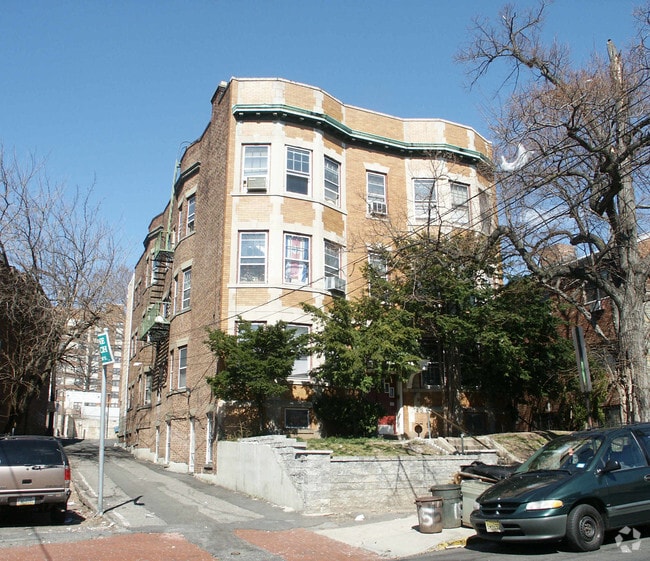
Property Record
13 Myrtle Ave, Belleville, NJ 07109
NEARBY LISTINGS FOR SALE OR LEASE
Property Detail
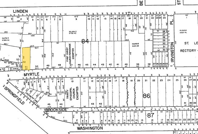
13 Myrtle Ave
09-00084-0000-00051
50 X 150
Apartment
Essex
X
New Jersey
34013C0151F
51
2023
0.17 AC
2025
Irvington
011900
Northern New Jersey
9,500 SF
Newark, NJ-PA
DEMOGRAPHICS near 13 Myrtle Ave
1 Mile
3 Mile
5 Mile
2024 Total Population
63,571
373,833
796,802
2029 Population
61,378
364,015
776,157
Pop Growth 2024-2029
(3.45%)
(2.63%)
(2.59%)
Average Age
37
37
38
2024 Total Households
22,723
133,891
287,984
HH Growth 2024-2029
(3.68%)
(2.72%)
(2.65%)
Median Household Inc
$49,538
$53,414
$59,702
Avg Household Size
2.70
2.60
2.60
2024 Avg HH Vehicles
1.00
1.00
1.00
Median Home Value
$244,660
$343,262
$380,195
Median Year Built
1953
1957
1958
Nearby Places
Map Layers
Map Styles
 Street
 Aerial
- Restaurants
- Banks
- Shops
- Fitness
- Groceries
PUBLIC TRANSPORTATION
COMMUTER RAIL
Lyndhurst (Main/Port Jervis Line - NJ Transit Commuter Rail (NJ Transit))
DRIVE
WALK
Distance
Lyndhurst (Main/Port Jervis Line - NJ Transit Commuter Rail (NJ Transit))
8 min
2.8 mi
Kingsland (Main/Port Jervis Line - NJ Transit Commuter Rail (NJ Transit))
DRIVE
WALK
Distance
Kingsland (Main/Port Jervis Line - NJ Transit Commuter Rail (NJ Transit))
6 min
2.9 mi
AIRPORT
Newark Liberty International
DRIVE
WALK
Distance
Newark Liberty International
18 min
11.2 mi
LaGuardia
DRIVE
WALK
Distance
LaGuardia
40 min
21.4 mi
John F Kennedy International
DRIVE
WALK
Distance
John F Kennedy International
49 min
29.5 mi
Freight Ports
Port Newark Container Terminal
DRIVE
WALK
Distance
Port Newark Container Terminal
21 min
11.0 mi
Nearby Properties
Address
Land Use
TOTAL SIZE
Lot Size
Zoning
Address
Land Use
TOTAL SIZE
Lot Size
Zoning
3,956 SF
250 AC
C2
Address
Land Use
TOTAL SIZE
Lot Size
Zoning
2,500 SF
43.35 AC
Address
Land Use
TOTAL SIZE
Lot Size
Zoning
5 AC
H
Address
Land Use
TOTAL SIZE
Lot Size
Zoning
5.80 AC
CGI
Address
Land Use
TOTAL SIZE
Lot Size
Zoning
17.97 AC
Address
Land Use
TOTAL SIZE
Lot Size
Zoning
8.88 AC
ORD
Address
Land Use
TOTAL SIZE
Lot Size
Zoning
1,218 SF
41.30 AC
RB
Address
Land Use
TOTAL SIZE
Lot Size
Zoning
12.54 AC
OPRP
Address
Land Use
TOTAL SIZE
Lot Size
Zoning
100,014 SF
8.80 AC
M2
Address
Land Use
TOTAL SIZE
Lot Size
Zoning
3.31 AC
Address
Land Use
TOTAL SIZE
Lot Size
Zoning
1.12 AC
M-O
Address
Land Use
TOTAL SIZE
Lot Size
Zoning
2.64 AC
Address
Land Use
TOTAL SIZE
Lot Size
Zoning
Address
Land Use
TOTAL SIZE
Lot Size
Zoning
11.49 AC
M-1
Address
Land Use
TOTAL SIZE
Lot Size
Zoning
275,260 SF
11.88 AC
Address
Land Use
TOTAL SIZE
Lot Size
Zoning
3.26 AC
PR
Address
Land Use
TOTAL SIZE
Lot Size
Zoning
0.17 AC
BCR1
Address
Land Use
TOTAL SIZE
Lot Size
Zoning
24.29 AC
Address
Land Use
TOTAL SIZE
Lot Size
Zoning
71,634 SF
12.31 AC
M1
Address
Land Use
TOTAL SIZE
Lot Size
Zoning
1.67 AC
BCR1
Address
Land Use
TOTAL SIZE
Lot Size
Zoning
860 SF
0.96 AC
R100
Address
Land Use
TOTAL SIZE
Lot Size
Zoning
267,069 SF
6.15 AC
Address
Land Use
TOTAL SIZE
Lot Size
Zoning
Address
Land Use
TOTAL SIZE
Lot Size
Zoning
3.20 AC
BSRD
Address
Land Use
TOTAL SIZE
Lot Size
Zoning
224 SF
0.94 AC
BCR1
Address
Land Use
TOTAL SIZE
Lot Size
Zoning
329,464 SF
15.82 AC
Address
Land Use
TOTAL SIZE
Lot Size
Zoning
9.98 AC
R-1
Address
Land Use
TOTAL SIZE
Lot Size
Zoning
0.22 AC
Address
Land Use
TOTAL SIZE
Lot Size
Zoning
7.22 AC
M-3
Address
Land Use
TOTAL SIZE
Lot Size
Zoning
9.38 AC
B-A
The World's #1 Commercial Real Estate Marketplace
Connect with us
© 2025 CoStar Group
The information above has been obtained from sources believed reliable. While we do not doubt its accuracy we have not verified it and make no guarantee, warranty or representation about it. It is your responsibility to independently confirm its accuracy and completeness. Any projections, opinions, assumptions, or estimates used are for example only and do not represent the current or future performance of the property. The value of this transaction to you depends on tax and other factors which should be evaluated by your tax, financial, and legal advisors. You and your advisors should conduct a careful, independent investigation of the property to determine to your satisfaction the suitability of the property for your needs.