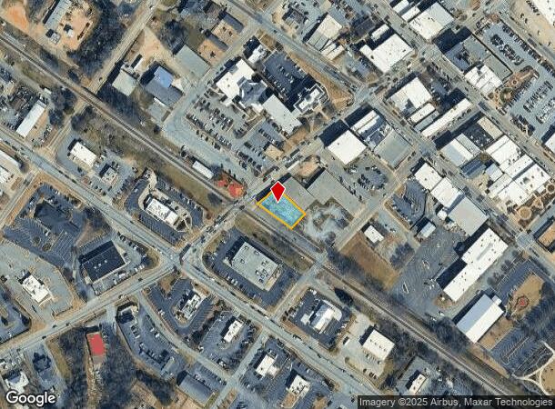
Property Record
13 N Broad St, Winder, GA 30680
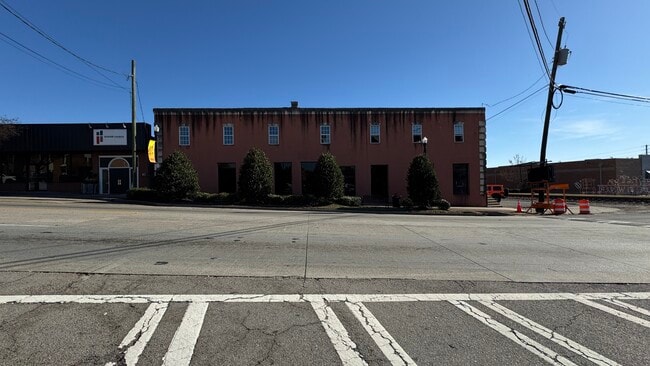


This Property Is For Sale
NEARBY LISTINGS FOR SALE OR LEASE
Property Detail
13 N Broad St
Atlanta-Sandy Springs-Roswell, GA
Property Wh Pool
WN12-175
LOT 1-WAR HILL CHURCH-EXEMPT
Religious
Barrow
X
Georgia
13013C0126D
1
0
0.26 AC
2025
S Barrow
180204
Atlanta
21,250 SF
DEMOGRAPHICS near 13 N Broad St
1 mile
3 mile
5 mile
2024 Total Population
6,397
27,604
49,037
2029 Population
7,461
32,345
57,485
Pop Growth 2024-2029
+ 16.63%
+ 17.18%
+ 17.23%
Average Age
37
38
37
2024 Total Households
2,449
9,825
16,966
HH Growth 2024-2029
+ 16.78%
+ 17.31%
+ 17.35%
Median Household Inc
$41,678
$58,901
$63,876
Avg Household Size
2.50
2.80
2.80
2024 Avg HH Vehicles
2.00
2.00
2.00
Median Home Value
$164,095
$195,394
$202,835
Median Year Built
1980
1994
1997
Nearby Places
Map Layers
Map Styles
 Street
 Aerial
Transit
 Traffic
 Biking
Places
Listings with unknown addresses are not visible on the map
- Restaurants
- Banks
- Shops
- Fitness
- Groceries
Nearby Properties
Address
Land Use
TOTAL SIZE
Lot Size
Zoning
Address
Land Use
TOTAL SIZE
Lot Size
Zoning
1,456 SF
1,732.81 AC
G
Address
Land Use
TOTAL SIZE
Lot Size
Zoning
165,737 SF
124.90 AC
G
Address
Land Use
TOTAL SIZE
Lot Size
Zoning
105,850 SF
61 AC
G
Address
Land Use
TOTAL SIZE
Lot Size
Zoning
6,928 SF
358.89 AC
AC
Address
Land Use
TOTAL SIZE
Lot Size
Zoning
690,427 SF
156.03 AC
M-1
Address
Land Use
TOTAL SIZE
Lot Size
Zoning
165,737 SF
9.70 AC
G
Address
Land Use
TOTAL SIZE
Lot Size
Zoning
50,000 SF
29 AC
G
Address
Land Use
TOTAL SIZE
Lot Size
Zoning
89,684 SF
64.92 AC
B-2
Address
Land Use
TOTAL SIZE
Lot Size
Zoning
20,132 SF
56.30 AC
M-2
Address
Land Use
TOTAL SIZE
Lot Size
Zoning
38,000 SF
362.35 AC
G,R-1A
Address
Land Use
TOTAL SIZE
Lot Size
Zoning
189,400 SF
24.79 AC
C-2
Address
Land Use
TOTAL SIZE
Lot Size
Zoning
233,462 SF
25.22 AC
C-2
Address
Land Use
TOTAL SIZE
Lot Size
Zoning
83,937 SF
17.83 AC
B-1
Address
Land Use
TOTAL SIZE
Lot Size
Zoning
35,790 SF
69.65 AC
G
Address
Land Use
TOTAL SIZE
Lot Size
Zoning
81,934 SF
30.94 AC
M-2
Address
Land Use
TOTAL SIZE
Lot Size
Zoning
3,370 SF
352.38 AC
G,TNPD
Address
Land Use
TOTAL SIZE
Lot Size
Zoning
60,540 SF
79.35 AC
AG
Address
Land Use
TOTAL SIZE
Lot Size
Zoning
48,998 SF
15.53 AC
B-1
Address
Land Use
TOTAL SIZE
Lot Size
Zoning
3,462 SF
10.05 AC
G,R-3
Address
Land Use
TOTAL SIZE
Lot Size
Zoning
2,160 SF
23.93 AC
B-1
Address
Land Use
TOTAL SIZE
Lot Size
Zoning
4,210 SF
3.30 AC
G
Address
Land Use
TOTAL SIZE
Lot Size
Zoning
51,753 SF
9.15 AC
B-2,R-3
Address
Land Use
TOTAL SIZE
Lot Size
Zoning
4,405 SF
7.48 AC
B-1,R-1,R-
Address
Land Use
TOTAL SIZE
Lot Size
Zoning
1,620 SF
19.32 AC
R-2
Address
Land Use
TOTAL SIZE
Lot Size
Zoning
14,800 SF
57.87 AC
M-1
Address
Land Use
TOTAL SIZE
Lot Size
Zoning
20,592 SF
66.11 AC
G
Address
Land Use
TOTAL SIZE
Lot Size
Zoning
93,959 SF
14.28 AC
B-1
Address
Land Use
TOTAL SIZE
Lot Size
Zoning
30,575 SF
7.27 AC
G,R-1A
Address
Land Use
TOTAL SIZE
Lot Size
Zoning
1,232 SF
15.07 AC
B-1,R-2
Address
Land Use
TOTAL SIZE
Lot Size
Zoning
59,898 SF
38.86 AC
M-1
The World's #1 Commercial Real Estate Marketplace
Connect with us
© 2026 CoStar Group
The information above has been obtained from sources believed reliable. While we do not doubt its accuracy we have not verified it and make no guarantee, warranty or representation about it. It is your responsibility to independently confirm its accuracy and completeness. Any projections, opinions, assumptions, or estimates used are for example only and do not represent the current or future performance of the property. The value of this transaction to you depends on tax and other factors which should be evaluated by your tax, financial, and legal advisors. You and your advisors should conduct a careful, independent investigation of the property to determine to your satisfaction the suitability of the property for your needs.