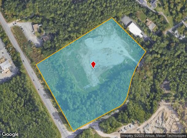
Property Record
13 Page Rd, Londonderry, NH 03053

NEARBY LISTINGS FOR SALE OR LEASE
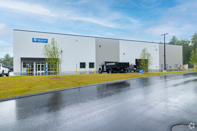
Property Detail
13 Page Rd
LOND-000017-000000-000027
Rockingham
Commercialacreage
New Hampshire
X
27-0
33011C0395D
13.88 AC
2025
Rockingham
2025
Boston
003703
Boston-Cambridge-Newton, MA-NH
2,464 SF
DEMOGRAPHICS near 13 Page Rd
1 mile
3 mile
5 mile
2024 Total Population
1,297
21,921
91,572
2029 Population
1,377
22,800
93,861
Pop Growth 2024-2029
+ 6.17%
+ 4.01%
+ 2.50%
Average Age
42
41
41
2024 Total Households
494
8,549
36,022
HH Growth 2024-2029
+ 6.07%
+ 3.98%
+ 2.47%
Median Household Inc
$111,734
$101,754
$87,393
Avg Household Size
2.60
2.50
2.40
2024 Avg HH Vehicles
2.00
2.00
2.00
Median Home Value
$418,750
$366,574
$338,469
Median Year Built
1989
1988
1976
Nearby Places
Map Layers
Map Styles
 Street
 Aerial
Transit
 Traffic
 Biking
Places
Listings with unknown addresses are not visible on the map
- Restaurants
- Banks
- Shops
- Fitness
- Groceries
PUBLIC TRANSPORTATION
AIRPORT
Manchester Boston Regional
Drive
Walk
Distance
Manchester Boston Regional
12 min
4.6 mi
Freight Ports
Port of Boston
Drive
Walk
Distance
Port of Boston
76 min
50.1 mi
Nearby Properties
Address
Land Use
TOTAL SIZE
Lot Size
Zoning
Address
Land Use
TOTAL SIZE
Lot Size
Zoning
768,020 SF
74.47 AC
I-II
Address
Land Use
TOTAL SIZE
Lot Size
Zoning
383,493 SF
34.51 AC
Address
Land Use
TOTAL SIZE
Lot Size
Zoning
603,357 SF
45.12 AC
GB
Address
Land Use
TOTAL SIZE
Lot Size
Zoning
8,064 SF
34.29 AC
Address
Land Use
TOTAL SIZE
Lot Size
Zoning
1,710 SF
65 AC
AR-I
Address
Land Use
TOTAL SIZE
Lot Size
Zoning
3,748 SF
14.69 AC
Address
Land Use
TOTAL SIZE
Lot Size
Zoning
0.60 AC
PZ
Address
Land Use
TOTAL SIZE
Lot Size
Zoning
42,228 SF
15.58 AC
PZ
Address
Land Use
TOTAL SIZE
Lot Size
Zoning
50.47 AC
GB
Address
Land Use
TOTAL SIZE
Lot Size
Zoning
723,875 SF
38.08 AC
Address
Land Use
TOTAL SIZE
Lot Size
Zoning
49,788 SF
34.73 AC
Address
Land Use
TOTAL SIZE
Lot Size
Zoning
180,600 SF
14.19 AC
IND-I
Address
Land Use
TOTAL SIZE
Lot Size
Zoning
366,008 SF
41.69 AC
IND-I
Address
Land Use
TOTAL SIZE
Lot Size
Zoning
487,970 SF
79.74 AC
IND-I
Address
Land Use
TOTAL SIZE
Lot Size
Zoning
201,831 SF
18.46 AC
IND-II
Address
Land Use
TOTAL SIZE
Lot Size
Zoning
151,002 SF
6.95 AC
PZ
Address
Land Use
TOTAL SIZE
Lot Size
Zoning
119,139 SF
25.87 AC
IND-I
Address
Land Use
TOTAL SIZE
Lot Size
Zoning
142,318 SF
26.13 AC
GB
Address
Land Use
TOTAL SIZE
Lot Size
Zoning
180,474 SF
18.60 AC
Address
Land Use
TOTAL SIZE
Lot Size
Zoning
227,589 SF
GB
Address
Land Use
TOTAL SIZE
Lot Size
Zoning
244,637 SF
27.28 AC
IND-II
Address
Land Use
TOTAL SIZE
Lot Size
Zoning
304,312 SF
29.62 AC
IND-II
Address
Land Use
TOTAL SIZE
Lot Size
Zoning
171,811 SF
44.42 AC
Address
Land Use
TOTAL SIZE
Lot Size
Zoning
13,395 SF
8.16 AC
PZ
Address
Land Use
TOTAL SIZE
Lot Size
Zoning
116.34 AC
IND-II
Address
Land Use
TOTAL SIZE
Lot Size
Zoning
162,272 SF
9.69 AC
Address
Land Use
TOTAL SIZE
Lot Size
Zoning
192,520 SF
34.20 AC
Address
Land Use
TOTAL SIZE
Lot Size
Zoning
187,046 SF
17.40 AC
PZ
Address
Land Use
TOTAL SIZE
Lot Size
Zoning
24.20 AC
GB
Address
Land Use
TOTAL SIZE
Lot Size
Zoning
112,851 SF
10.93 AC
The World's #1 Commercial Real Estate Marketplace
Connect with us
© 2026 CoStar Group
The information above has been obtained from sources believed reliable. While we do not doubt its accuracy we have not verified it and make no guarantee, warranty or representation about it. It is your responsibility to independently confirm its accuracy and completeness. Any projections, opinions, assumptions, or estimates used are for example only and do not represent the current or future performance of the property. The value of this transaction to you depends on tax and other factors which should be evaluated by your tax, financial, and legal advisors. You and your advisors should conduct a careful, independent investigation of the property to determine to your satisfaction the suitability of the property for your needs.