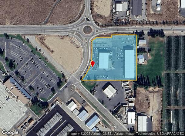
Property Record
13 Pangborn Rd, East Wenatchee, WA 98802
NEARBY LISTINGS FOR SALE OR LEASE
-
-
View all East Wenatchee listings for sale on LoopNet.com
Property Detail
13 Pangborn Rd
Other Market Areas
Binding Site Plan 09L-0002A
Wenatchee, WA
LOT 1 EX TAX 13; BINDING SITE PLAN #96-0002A
22-21-16-10074
Douglas
Commercialnec
Washington
2024
1
2025
3.65 AC
950300
Washington State Area
30,400 SF
DEMOGRAPHICS near 13 Pangborn Rd
1 Mile
3 Mile
5 Mile
2024 Total Population
421
15,560
42,169
2029 Population
455
16,788
44,860
Pop Growth 2024-2029
+ 8.08%
+ 7.89%
+ 6.38%
Average Age
42
40
38
2024 Total Households
141
5,402
14,764
HH Growth 2024-2029
+ 8.51%
+ 7.90%
+ 6.50%
Median Household Inc
$96,785
$74,404
$69,514
Avg Household Size
2.70
2.80
2.80
2024 Avg HH Vehicles
3.00
2.00
2.00
Median Home Value
$463,749
$376,823
$372,633
Median Year Built
1989
1991
1985
Nearby Places
Map Layers
Map Styles
 Street
 Aerial
- Restaurants
- Banks
- Shops
- Fitness
- Groceries
PUBLIC TRANSPORTATION
COMMUTER RAIL
Wenatchee Amtrak (Empire Builder - Amtrak)
DRIVE
WALK
Distance
Wenatchee Amtrak (Empire Builder - Amtrak)
12 min
5.7 mi
AIRPORT
Pangborn Memorial
DRIVE
WALK
Distance
Pangborn Memorial
1 min
0.5 mi
Freight Ports
Port of Seattle
DRIVE
WALK
Distance
Port of Seattle
199 min
157.4 mi
SALE & LEASE HISTORY
LISTING DATE
SALE/LEASE

Oct 07, 2016
For Sale
Nearby Properties
Address
Land Use
TOTAL SIZE
Lot Size
Zoning
Address
Land Use
TOTAL SIZE
Lot Size
Zoning
Address
Land Use
TOTAL SIZE
Lot Size
Zoning
205,562 SF
12.80 AC
I-G
Address
Land Use
TOTAL SIZE
Lot Size
Zoning
189,183 SF
10.54 AC
I-G
Address
Land Use
TOTAL SIZE
Lot Size
Zoning
262,540 SF
11.20 AC
I-G
Address
Land Use
TOTAL SIZE
Lot Size
Zoning
96,785 SF
44.60 AC
I-G
Address
Land Use
TOTAL SIZE
Lot Size
Zoning
112,254 SF
4.34 AC
Address
Land Use
TOTAL SIZE
Lot Size
Zoning
130,864 SF
6.91 AC
R-M
Address
Land Use
TOTAL SIZE
Lot Size
Zoning
1,440 SF
84.05 AC
R-EPF
Address
Land Use
TOTAL SIZE
Lot Size
Zoning
111,334 SF
33.92 AC
I-G
Address
Land Use
TOTAL SIZE
Lot Size
Zoning
97,102 SF
386.47 AC
I-G
Address
Land Use
TOTAL SIZE
Lot Size
Zoning
701,567 SF
2
Address
Land Use
TOTAL SIZE
Lot Size
Zoning
80,000 SF
18.36 AC
R-L
Address
Land Use
TOTAL SIZE
Lot Size
Zoning
48,616 SF
2
Address
Land Use
TOTAL SIZE
Lot Size
Zoning
58,254 SF
10.18 AC
2
Address
Land Use
TOTAL SIZE
Lot Size
Zoning
92,360 SF
52.91 AC
Address
Land Use
TOTAL SIZE
Lot Size
Zoning
106,050 SF
38.62 AC
I-G
Address
Land Use
TOTAL SIZE
Lot Size
Zoning
68,169 SF
5.60 AC
Address
Land Use
TOTAL SIZE
Lot Size
Zoning
117,782 SF
9.19 AC
AC-10
Address
Land Use
TOTAL SIZE
Lot Size
Zoning
30,480 SF
954.84 AC
A-D
Address
Land Use
TOTAL SIZE
Lot Size
Zoning
93.72 AC
Address
Land Use
TOTAL SIZE
Lot Size
Zoning
8,190 SF
9.63 AC
Address
Land Use
TOTAL SIZE
Lot Size
Zoning
38,439 SF
4.99 AC
2
Address
Land Use
TOTAL SIZE
Lot Size
Zoning
55.16 AC
Address
Land Use
TOTAL SIZE
Lot Size
Zoning
46,361 SF
64.26 AC
Address
Land Use
TOTAL SIZE
Lot Size
Zoning
54,600 SF
4.29 AC
Address
Land Use
TOTAL SIZE
Lot Size
Zoning
31,228 SF
4.54 AC
Address
Land Use
TOTAL SIZE
Lot Size
Zoning
34,000 SF
5 AC
R-L
Address
Land Use
TOTAL SIZE
Lot Size
Zoning
43,700 SF
8.56 AC
A-D
Address
Land Use
TOTAL SIZE
Lot Size
Zoning
45,705 SF
4.91 AC
Address
Land Use
TOTAL SIZE
Lot Size
Zoning
45,705 SF
2
The World's #1 Commercial Real Estate Marketplace
Connect with us
© 2026 CoStar Group
The information above has been obtained from sources believed reliable. While we do not doubt its accuracy we have not verified it and make no guarantee, warranty or representation about it. It is your responsibility to independently confirm its accuracy and completeness. Any projections, opinions, assumptions, or estimates used are for example only and do not represent the current or future performance of the property. The value of this transaction to you depends on tax and other factors which should be evaluated by your tax, financial, and legal advisors. You and your advisors should conduct a careful, independent investigation of the property to determine to your satisfaction the suitability of the property for your needs.