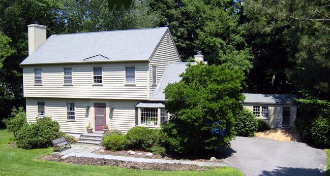
Property Record
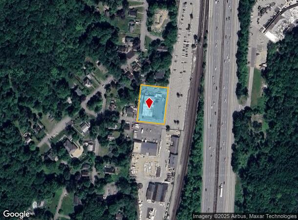
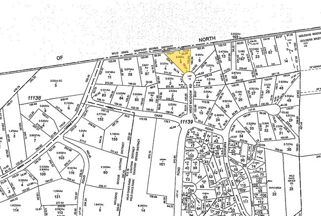
13 Railroad Ave, Goldens Bridge, NY 10526
NEARBY LISTINGS FOR SALE OR LEASE
-
-
View all Goldens Bridge listings for sale on LoopNet.com
Property Detail
13 Railroad Ave
3000-004-00C-11115-000-0005
Westchester
Warehouse
New York
X
4.c
36119C0066F
0.83 AC
2025
North
2024
Westchester/So Connecticut
012501
New York-Jersey City-White Plains, NY-NJ
DEMOGRAPHICS near 13 Railroad Ave
1 Mile
3 Mile
5 Mile
2024 Total Population
1,343
13,236
42,291
2029 Population
1,303
12,928
41,500
Pop Growth 2024-2029
(2.98%)
(2.33%)
(1.87%)
Average Age
43
45
45
2024 Total Households
481
4,701
15,392
HH Growth 2024-2029
(3.33%)
(2.72%)
(1.90%)
Median Household Inc
$234,256
$189,285
$149,285
Avg Household Size
2.80
2.70
2.60
2024 Avg HH Vehicles
2.00
2.00
2.00
Median Home Value
$762,672
$726,420
$646,303
Median Year Built
1970
1970
1974
Nearby Places
- Restaurants
- Banks
- Shops
- Fitness
- Groceries
PUBLIC TRANSPORTATION
COMMUTER RAIL
Golden's Bridge Station (Harlem Line - Metro-North Commuter Railroad Company (Metro-North))
DRIVE
WALK
Distance
Golden's Bridge Station (Harlem Line - Metro-North Commuter Railroad Company (Metro-North))
2 min
9 min
0.5 mi
Katonah Station (Harlem Line - Metro-North Commuter Railroad Company (Metro-North))
DRIVE
WALK
Distance
Katonah Station (Harlem Line - Metro-North Commuter Railroad Company (Metro-North))
7 min
3.5 mi
AIRPORT
Westchester County
DRIVE
WALK
Distance
Westchester County
24 min
17.4 mi
New York Stewart International
DRIVE
WALK
Distance
New York Stewart International
66 min
46.1 mi
Freight Ports
Port of New Haven
DRIVE
WALK
Distance
Port of New Haven
82 min
53.8 mi
Nearby Properties
Address
Land Use
TOTAL SIZE
Lot Size
Zoning
Address
Land Use
TOTAL SIZE
Lot Size
Zoning
38.19 AC
Address
Land Use
TOTAL SIZE
Lot Size
Zoning
1,078,069 SF
723.08 AC
Address
Land Use
TOTAL SIZE
Lot Size
Zoning
1,168.28 AC
Address
Land Use
TOTAL SIZE
Lot Size
Zoning
Address
Land Use
TOTAL SIZE
Lot Size
Zoning
10 AC
Address
Land Use
TOTAL SIZE
Lot Size
Zoning
Address
Land Use
TOTAL SIZE
Lot Size
Zoning
172.78 AC
Address
Land Use
TOTAL SIZE
Lot Size
Zoning
98.59 AC
Address
Land Use
TOTAL SIZE
Lot Size
Zoning
540,000 SF
206.12 AC
Address
Land Use
TOTAL SIZE
Lot Size
Zoning
120.59 AC
Address
Land Use
TOTAL SIZE
Lot Size
Zoning
1,984 SF
17.90 AC
R-120
Address
Land Use
TOTAL SIZE
Lot Size
Zoning
19.11 AC
Address
Land Use
TOTAL SIZE
Lot Size
Zoning
114.82 AC
Address
Land Use
TOTAL SIZE
Lot Size
Zoning
92.34 AC
Address
Land Use
TOTAL SIZE
Lot Size
Zoning
30.81 AC
Address
Land Use
TOTAL SIZE
Lot Size
Zoning
11.80 AC
Address
Land Use
TOTAL SIZE
Lot Size
Zoning
2,431 SF
58.02 AC
R-80
Address
Land Use
TOTAL SIZE
Lot Size
Zoning
10.79 AC
NS
Address
Land Use
TOTAL SIZE
Lot Size
Zoning
69.12 AC
Address
Land Use
TOTAL SIZE
Lot Size
Zoning
30.01 AC
Address
Land Use
TOTAL SIZE
Lot Size
Zoning
9.06 AC
Address
Land Use
TOTAL SIZE
Lot Size
Zoning
1,795 SF
25.31 AC
R-120
Address
Land Use
TOTAL SIZE
Lot Size
Zoning
13.03 AC
Address
Land Use
TOTAL SIZE
Lot Size
Zoning
0.57 AC
Address
Land Use
TOTAL SIZE
Lot Size
Zoning
Address
Land Use
TOTAL SIZE
Lot Size
Zoning
68.53 AC
Address
Land Use
TOTAL SIZE
Lot Size
Zoning
130.31 AC
Address
Land Use
TOTAL SIZE
Lot Size
Zoning
4.99 AC
Address
Land Use
TOTAL SIZE
Lot Size
Zoning
0.60 AC
Address
Land Use
TOTAL SIZE
Lot Size
Zoning
33.53 AC
The World's #1 Commercial Real Estate Marketplace
Connect with us
© 2025 CoStar Group
The information above has been obtained from sources believed reliable. While we do not doubt its accuracy we have not verified it and make no guarantee, warranty or representation about it. It is your responsibility to independently confirm its accuracy and completeness. Any projections, opinions, assumptions, or estimates used are for example only and do not represent the current or future performance of the property. The value of this transaction to you depends on tax and other factors which should be evaluated by your tax, financial, and legal advisors. You and your advisors should conduct a careful, independent investigation of the property to determine to your satisfaction the suitability of the property for your needs.